
I’m parked at a pullout somewhere between Carmel and Big Sur, engine off, watching fog roll across headlands while waves crash against rocks 200 feet below. It’s 9 AM on a Tuesday in October, and I’ve already stopped five times in the past hour—not because I needed gas or coffee, but because every mile of Pacific Coast Highway reveals another vista too stunning to pass without stopping.
After driving California’s Highway 1 eleven times over fifteen years—sometimes the full 655-mile route from Dana Point to Leggett, other times just favorite sections—I’ve learned something crucial: the Pacific Coast Highway isn’t about efficiently driving from Point A to Point B. It’s about the stops. The unexpected beach where elephant seals haul out by the hundreds. The hidden trail leading to turquoise coves. The roadside oyster farm serving what you just pulled from the bay. The viewpoint where light hits cliffs in ways that make you understand why Ansel Adams spent years photographing this coastline.
Most Pacific Coast Highway guides list 15-25 “must-see” stops and call it comprehensive. But Highway 1 holds literally hundreds of worthy stops—scenic pullouts, beaches, trails, towns, restaurants, and natural wonders that deserve more than passing glances through your windshield. This complete guide maps the best Pacific Coast Highway stops section by section, from southern Orange County to northern Mendocino, organized so you can plan perfect road trips whether you have three days or three weeks.
Quick Reference: Best Pacific Coast Highway Stops by Section
| Section | Distance | Must-See Stops | Drive Time | Best For |
|---|---|---|---|---|
| Dana Point to Malibu | 85 miles | 12 stops | 3-4 hours | SoCal beaches, surfing |
| Malibu to Santa Barbara | 75 miles | 8 stops | 2.5 hours | Wine country access |
| Santa Barbara to Big Sur | 140 miles | 15 stops | 4-5 hours | Coastal towns, seals |
| Big Sur Section | 90 miles | 20 stops | 3-4 hours | Dramatic cliffs, waterfalls |
| Carmel to Santa Cruz | 45 miles | 10 stops | 2 hours | Monterey Peninsula |
| Santa Cruz to San Francisco | 75 miles | 14 stops | 3 hours | Half Moon Bay, beaches |
| San Francisco to Mendocino | 150 miles | 18 stops | 4-5 hours | Redwoods, remote coast |
Total Highway 1 Length: 655 miles (Dana Point to Leggett)
Recommended Minimum Time: 5-7 days to properly experience key stops
Best Direction: South to north (easier pullout access, sun behind you)
Understanding Pacific Coast Highway: What You Need to Know Before Driving
Highway 1—officially California State Route 1, commonly called the Pacific Coast Highway or PCH—stretches 655 miles from Dana Point in Orange County north to Leggett in Mendocino County where it merges with Highway 101. This isn’t the fastest route between Southern and Northern California (that’s Interstate 5), but it’s arguably the most beautiful drive in America.
The highway hugs California’s coastline, sometimes running at sea level beside beaches, other times carved into cliffsides 500 feet above crashing waves. Construction began in the 1930s with Big Sur’s famous sections completed last—the highway wasn’t fully paved until 1964. The engineering remains remarkable: bridges span canyons, tunnels pierce headlands, and the roadway itself defies gravity clinging to mountainsides.
Important 2025 Update: Big Sur sections of Highway 1 periodically close due to landslides—this dramatic coastline requires constant maintenance. Check current conditions at Caltrans QuickMap before driving. When sections close (as happened 2017-2018 and occasionally since), you’ll detour inland via Highway 101, missing the most spectacular coastal sections but still able to access stops from both directions.
Which Direction Should You Drive?
Most guides recommend south-to-north (San Diego area toward San Francisco) for three compelling reasons: you drive in the lane closest to ocean views with easiest pullout access, the sun sits behind you (not in your eyes) most of the day, and traffic generally flows lighter northbound than southbound.
I’ve driven both directions multiple times. Northbound wins for these practical advantages, though southbound provides equally stunning views—you just crane your neck slightly and cross traffic lanes to reach pullouts. Choose based on your starting location rather than obsessing over direction.
How Much Time Do You Actually Need?
The 655-mile drive takes roughly 17 hours of pure driving without stops—which means absolutely nothing in practical terms because you’ll stop constantly. Plan minimum 5-7 days for San Diego/Orange County to San Francisco, or 3-5 days for the most popular segment (Malibu to Carmel). Weekend warriors can drive specific sections: Big Sur in two days, Monterey Peninsula in one, Southern California coast over a long weekend.
Budget 30-45 minutes of stopping time for every hour of driving. That scenic pullout “just for a quick photo” turns into 20 minutes once you walk to the viewpoint, take pictures, and simply absorb the view. Multiply this by dozens of stops and you understand why Highway 1 requires patience.
What’s the Best Time to Drive PCH?
Spring (April-May) and fall (September-October) deliver ideal conditions: comfortable temperatures, clearer skies, smaller crowds, and better accommodation rates. Summer brings peak crowds, high prices, frequent fog obscuring coastal views (especially mornings), but also longest daylight hours and warmest weather for beach stops.
Winter (November-March) offers solitude and dramatic storm-watching but carries risks: rain can trigger landslides closing sections, some businesses reduce hours or close entirely, and gray weather diminishes those postcard views you’re expecting. If you’re flexible about conditions, winter PCH driving provides unique moody beauty and exceptional value.
Fog patterns matter significantly. Coastal fog often blankets Highway 1 until 11 AM-1 PM, then burns off revealing gorgeous afternoons. Plan photo stops for mid-afternoon through sunset when conditions typically peak. That 7 AM coastal start sounds ambitious until you’re driving through pea-soup fog seeing nothing.
Southern Section: Dana Point to Malibu (85 Miles)
This southern stretch launches your Pacific Coast Highway journey through Orange County and Los Angeles coastal communities where beach culture defines everything. You’ll encounter more traffic and development than northern sections, but also incredible surf breaks, charming beach towns, and that quintessential Southern California energy.
Dana Point (Mile 0)
Highway 1 officially begins (or ends, depending on direction) at the intersection of Pacific Coast Highway and Camino Capistrano in Dana Point. This harbor town named for Richard Henry Dana who wrote “Two Years Before the Mast” about California’s 1830s hide trading offers a fitting start with Dana Point Harbor providing boat watching, restaurants, and the Ocean Institute educational center.
Stop at Baby Beach inside the harbor—protected cove with gentle waves perfect for quick swims. Doheny State Beach adjacent to the harbor entrance provides classic California beach day possibilities with surf, sand, and facilities. The Salt Creek Beach Park Overlook just north offers elevated views of dramatic coastline, tide pools, and the Ritz-Carlton perched on bluffs.
Laguna Beach (Mile 8)
Laguna Beach ranks among California’s most picturesque beach towns—art galleries line streets, coves hide between rocky outcrops, and million-dollar homes cascade down hillsides toward azure water. Take time here.
Park downtown and explore on foot. Main Beach in the heart of town sees crowds but provides people-watching, volleyball, basketball courts, and that classic SoCal beach scene. Victoria Beach (parking limited, arrive early or late) features the iconic Pirate Tower—a 60-foot tall tower built in 1926 to allow the clifftop mansion resident beach access. It’s locked now but photographs beautifully against waves.
Heisler Park above Laguna’s northern beaches offers the best coastal walking with paved paths atop bluffs, pocket beaches accessed via stairs, tide pools, and views that cost zero dollars. Sunset here ranks among Orange County’s finest. For lunch, Driftwood Kitchen right on Main Beach serves excellent seafood with ocean views, while Zinc Cafe provides healthy, delicious, affordable options downtown.
Crystal Cove State Park (Mile 15)
Three miles of undeveloped coastline and 2,400 acres of inland canyon—this state park preserves what Orange County coast looked like before development consumed every inch. Crystal Cove Historic District features 1930s-40s beach cottages (some available for overnight rental—book 6+ months ahead) that create time-capsule atmosphere. Walk among them, then hit the beach where tide pools, swimming, and simply walking on sand that isn’t wall-to-wall people creates relief from urban stretch.
The Beachcomber Cafe in the Historic District serves breakfast, lunch, and drinks steps from sand—order fish tacos and eat outside. Above on the bluff, Shake Shack at Crystal Cove Shopping Center provides burgers and malts with ocean views (yes, it’s a chain, but the setting elevates it).
Inland, El Moro Canyon offers hiking through coastal sage scrub and oak woodland if you need to stretch legs and escape beach crowds. The 3-mile loop moderately challenges without overwhelming—add this if you’ve been sitting in car too long.
Newport Beach (Mile 22)
Newport Beach means yachts, money, and “The OC” lifestyle. Newport Pier and surrounding beach draw surfers and sunbathers. Walk the pier (free) watching surfers below and scanning for dolphins. Balboa Peninsula features the Balboa Pier and Fun Zone amusement area—Ferris wheel, arcade, and Balboa Bar (frozen banana dipped in chocolate—trust me). The Balboa Island Ferry ($2.50 per car) shuttles between peninsula and Balboa Island—it’s a 3-minute ride but feels nostalgic and fun.
For fresh fish, Bear Flag Fish Company near Balboa Pier serves outstanding fish tacos and poke bowls. Ruby’s Diner at the end of Newport Pier delivers classic diner food with unbeatable views—go for the setting, not culinary revolution.
Huntington Beach (Mile 30)
Surf City USA lives up to its nickname. Huntington Beach Pier stretches 1,850 feet into the Pacific—one of California’s longest. The surrounding beach provides consistent surf, regular competitions, bonfires (with permit), and volleyball nets. Downtown Main Street parallel to the beach holds surf shops, restaurants, and bars creating lively atmosphere especially summer weekends.
Duke’s Huntington Beach right on the sand serves Hawaiian-inspired food with oceanfront dining. Pacific City shopping center at PCH and Huntington features multiple restaurants with rooftop and patio seating—stop for lunch or drinks with views.
Bolsa Chica Ecological Reserve just north provides wetland contrast to urban beaches—1,300 acres of restored wetland housing over 200 bird species. Walk the 1.5-mile loop trail watching for herons, egrets, and migratory shorebirds. It’s free, easy, and completely different energy than the beach scene miles away.
Long Beach (Mile 42)
Long Beach transitions from beach town to urban port city. Belmont Shore area provides beach access with more local, less touristy vibe than previous stops. The Queen Mary permanently docked in Long Beach Harbor offers tours of the retired ocean liner—it’s touristy but legitimately interesting if you appreciate maritime history or Art Deco design.
Shoreline Village provides waterfront dining and shops, though it feels somewhat contrived. Skip unless you need a meal break. More authentic: drive through Naples neighborhood’s canals (inspired by Italian namesake) where houses sit on waterways and small bridges connect streets.
San Pedro (Mile 52)
San Pedro occupies LA Harbor’s edge with working-class, maritime character distinct from glitzier beach towns. Point Fermin Park offers clifftop views, a Victorian-era lighthouse (tours weekends), and tidepools accessed via stairs. Korean Bell of Friendship in nearby Angels Gate Park provides cultural landmark with Pacific panoramas.
Port of Los Angeles is working harbor but Cabrillo Marine Aquarium ($5 suggested donation) offers excellent introduction to Southern California marine life—tide pool touch tanks, local fish displays, and educational programs. Nearby Cabrillo Beach has both open ocean and protected bay sides—the latter perfect for calm swimming.
For food, San Pedro’s Croatian and Italian communities created excellent seafood restaurants. Busy Bee Market serves outstanding fish and chips, while Connie and Ted’s (actually in West Hollywood, but worth noting for LA) represents upscale seafood if you’re detouring into Los Angeles proper.
Palos Verdes Peninsula (Mile 58)
This affluent peninsula jutting into Pacific creates driving loop worth every minute. Take Palos Verdes Drive West south from PCH—the road winds along clifftops with constant ocean views and million-dollar homes. Terranea Resort perches on peninsula’s southern tip—stop for lunch or drinks at their Nelson’s restaurant with floor-to-ceiling windows overlooking ocean.
Point Vicente Lighthouse (tours limited) sits near dramatic cliffs where Point Vicente Interpretive Center ($2 suggested donation) teaches about gray whale migration and local ecology. December-April, watch for migrating whales from the viewing deck. Abalone Cove Shoreline Park provides tide pool access via steep trail—worth the effort for underwater gardens revealed at low tide.
Circle back north via Palos Verdes Drive East for slightly less dramatic but equally wealthy views, then reconnect with PCH heading toward Redondo Beach and beyond.
Manhattan, Hermosa, and Redondo Beaches (Miles 62-68)
These three beach cities blend together creating South Bay’s beach culture zone. Each has distinct personality:
Redondo Beach Pier and harbor create tourist-friendly area with restaurants, shops, and ocean activities—more developed and family-oriented. Hermosa Beach skews younger with volleyball culture (AVP tours stop here), active nightlife, and the Strand bike path providing breezy exercise. Manhattan Beach brings upscale sophistication—boutiques, trendy restaurants, and generally older, wealthier crowd.
All three share spectacular beaches—wide, sandy, and perfect for classic beach days. The Marvin Braude Bike Trail (locals call it “The Strand”) runs 22 miles from Pacific Palisades to Torrance Beach connecting these communities. Rent bikes and cruise car-free beside the ocean, stopping where whim dictates.
For food: The Stand in Hermosa and Manhattan serves excellent burgers and fries. Fishing with Dynamite in Manhattan Beach offers upscale seafood in relaxed atmosphere. Uncle Bill’s Pancake House in Manhattan Beach provides hearty breakfast—expect weekend waits.
Marina del Rey to Santa Monica (Miles 70-77)
Marina del Rey houses the world’s largest man-made small-craft harbor—13,000 boats filling a massive marina. The waterfront restaurants, while touristy, provide pleasant dining with yacht-watching. Venice Beach and its famous boardwalk lie just south—if you’ve never experienced Venice’s unique energy, stop for people-watching theater unlike anywhere else.
Santa Monica delivers iconic California—the Santa Monica Pier with its solar-powered Ferris wheel, 1920s carousel, arcade games, and Trapeze School where you can actually learn trapeze (book ahead). Route 66 officially ends at the pier—photo op with the “End of the Trail” sign draws crowds.
Third Street Promenade three blocks from beach provides pedestrian shopping and dining, though it’s become somewhat corporate. More authentic atmosphere exists in neighborhoods slightly inland. Santa Monica State Beach stretches wide and sandy with volleyball, bike path access, and that classic Southern California beach scene.
For food: Santa Monica Pier has typical boardwalk fare—corn dogs, funnel cakes, fish and chips. Better options sit blocks inland: Cassia serves Southeast Asian food in hip atmosphere, The Lobster provides seafood with ocean views, Tar & Roses offers excellent New American sharing plates.
Malibu (Miles 78-85)
Malibu stretches 21 miles along PCH but feels disconnected from previous urban beaches—more spread out, less walkable, definitely wealthier. Surfrider Beach next to Malibu Pier provides world-famous right-point break attracting expert surfers. Watch from the pier (free) or grab breakfast at Malibu Farm at pier’s end—overpriced but the views justify it.
Zuma Beach offers Malibu’s widest, sandiest beach with reliable surf, parking (pay), and facilities. Locals love it for space and relative accessibility. El Matador State Beach features dramatic rock formations, sea caves, and tide pools—small parking lot fills early on weekends, but the scenery rewards effort. Climb down stairs to reach the beach where golden rocks contrast turquoise water creating postcard scenes.
Getty Villa (free, reserve timed tickets online) houses J. Paul Getty’s antiquities collection in Roman villa replica overlooking the Pacific. Even if museums aren’t your thing, the architecture and gardens warrant stopping. For lunch, Malibu Seafood Fresh Fish Market & Patio Cafe serves excellent fish off boats that morning—order at counter, eat at picnic tables overlooking ocean. Cash only, arrive off-peak to avoid lines.
Central Section: Santa Barbara to Big Sur (230 Miles)
This stretch transitions from Mediterranean-climate Santa Barbara through increasingly dramatic coastline culminating in Big Sur’s legendary cliffs and canyons. You’ll encounter seals, state parks, historic missions, and some of California’s most photographed scenery.
Santa Barbara (Mile 160)
While not directly on Highway 1 (you briefly merge onto 101), Santa Barbara demands stopping. The “American Riviera” combines Spanish Colonial architecture, palm-lined beaches, excellent restaurants, and wine country access.
Stearns Wharf extends into ocean providing views, restaurants, and the Ty Warner Sea Center aquarium (focus on local marine life). Walk the wharf sunset, then dinner at waterfront restaurants. Santa Barbara Mission (tours, fee) showcases Spanish California history with beautiful architecture and gardens. Downtown’s State Street offers shopping, dining, and the Santa Barbara County Courthouse (free)—climb the tower for panoramic views.
Beach lovers head to East Beach beside the wharf for volleyball, swimming, and people-watching, or Butterfly Beach in Montecito for quieter, more upscale atmosphere where you might spot celebrities. For wine tasting, Funk Zone neighborhood hosts 30+ tasting rooms within walking distance—sample Santa Ynez Valley wines without driving to wine country.
Gaviota State Park (Mile 180)
Between Santa Barbara and** Gaviota,** Highway 1 merges with 101—you’ll stay on 101 through this section. Gaviota State Park provides beach access, pier, and Hot Springs Trail (2.5 miles round-trip) leading to natural hot springs tucked in canyon—the springs run lukewarm but the hike through creek-side trail provides beauty.
Refugio State Beach and El Capitan State Beach both offer camping, beach access, and palm-tree-backed sand creating tropical feel unusual for Central Coast. Quick stops for photos or longer stays if camping appeals.
Jalama Beach County Park (significant detour—14 miles off 101 via Jalama Road) rewards adventurous travelers with remote, windswept beach accessible only via winding road. Jalama Beach Store serves legendary burgers at the end of the road. It’s out of the way but delivers wild, uncrowded coastal experience impossible along main highway.
Solvang & Santa Ynez Valley (35 miles inland from 101)
While technically off Highway 1, this Danish-themed village and surrounding wine country merit the 45-minute detour. Solvang’s windmills, Tudor architecture, and bakeries selling æbleskiver create quirky charm. Surrounding wineries (Sunstone, Rideau, Beckmen) produce excellent wines at lower prices than Napa. Return to 101 and continue north.
Pismo Beach (Mile 205)
Pismo Beach represents classic Central Coast—wide sandy beach, laid-back vibe, and the famous Pismo Beach Pier extending into surf. The Monarch Butterfly Grove (November-February, free) hosts thousands of migrating Monarch butterflies clustering in eucalyptus trees—extraordinary natural spectacle. Walk the paved trail watching butterflies coat branches.
Downtown Pismo offers surf shops, seafood restaurants, and casual beach-town energy. Splash Cafe serves clam chowder in sourdough bowls that draw lines—arrive off-peak or order to-go. Oceano Dunes south of town allows vehicle driving on beach (permit required)—unique California experience seeing trucks and ATVs on sand.
Avila Beach & Avila Hot Springs nearby provide sheltered beach (warmer than most Central Coast) and natural hot springs soaking if you need relaxation.
Morro Bay (Mile 220)
Morro Rock, a 576-foot volcanic plug, dominates Morro Bay’s skyline and serves as harbor landmark. You can’t climb it (protected nesting site) but drive to its base for dramatic up-close views. The rock and surrounding Morro Bay State Park create habitat for peregrine falcons and other raptors.
Morro Bay Embarcadero lines the waterfront with restaurants, shops, and sea otters floating in kelp beds—bring binoculars for up-close otter watching. Taco Temple serves outstanding fish tacos, Dorn’s Breakers Cafe provides hearty breakfast with harbor views, and Dutchman’s Seafood House delivers fresh fish in casual atmosphere.
Morro Bay State Park offers hiking through eucalyptus groves with bay and rock views, plus the Museum of Natural History ($3) explaining local ecology and geology. Morro Strand State Beach provides miles of wind-swept beach perfect for walking but usually too cold for swimming.
Cayucos (Mile 225)
This sleepy beach town of 2,600 residents creates time-capsule atmosphere—wooden pier, antique stores, and Cayucos State Beach where locals still fish and families build bonfires. Brown Butter Cookie Company bakes cookies filling streets with aroma impossible to resist. Ruddell’s Smokehouse sells outstanding smoked fish—buy salmon or albacore for picnic supplies.
Cayucos Pier (free) offers ocean views and fishing without crowds. Walk it sunset watching surfers below. The town moves slowly—embrace it rather than fighting for faster pace.
Cambria (Mile 235)
Cambria transitions you toward Big Sur’s drama while maintaining small-town charm. Moonstone Beach provides elevated boardwalk (wheelchair accessible) stretching along bluffs with beach access via stairs. Walk the boardwalk any time but sunset brings magic—rocks catch golden light and tide pools reveal themselves.
Fiscalini Ranch Preserve offers easy 1-4 mile hiking along bluffs and through pine forest—free, dog-friendly, and locals’ favorite for good reason. Downtown Cambria splits between East Village (residential) and West Village (shops, galleries, restaurants).
For meals: Robin’s Restaurant serves globally-inspired food in cottage setting—reservations essential weekends. The Sea Chest Oyster Bar provides outstanding seafood in rustic atmosphere (no reservations, cash only, arrive early). Linn’s Restaurant is famous for olallieberry pie—get slice to go if nothing else.
Hearst Castle (Mile 245)
Hearst San Simeon State Historical Monument (reservations required, tours $25-36) showcases William Randolph Hearst’s 165-room hilltop estate combining Mediterranean Revival architecture with the world’s greatest art and antiques collection. Love it or hate it as ostentatious wealth display, the castle astounds with scale and craftsmanship.
Multiple tour options exist—Grand Rooms Tour provides overview, others focus on upstairs rooms, cottages, or gardens. All require reserving ahead (especially summer/weekends) and moderate walking/stairs. Even if you skip the tour, the Vista Point at San Simeon Cove provides views of castle on the hill and Elephant Seal Rookery below.
Piedras Blancas Elephant Seal Rookery (Mile 249)
One of Highway 1’s most extraordinary stops costs nothing and requires zero planning—massive northern elephant seals haul out on beach year-round with peak viewing December-March (breeding/birthing) and April-August (molting).
Pull into designated viewing area with boardwalks and interpretive signs. Hundreds to thousands of seals loll on beach—males weigh 5,000+ pounds, females 1,500 pounds. They’re loud (roaring, burping, snorting), smell funky (like combination of fish and wet dog), and mesmerizing to watch. Bulls fight for dominance, mothers nurse pups, and the entire colony creates scene from nature documentary happening steps away.
Stay 45 minutes minimum—the longer you watch, the more behavior you notice. Bring binoculars and camera with zoom. Docents (winter/spring) answer questions and share seal facts. This stop alone justifies the PCH drive.
Ragged Point (Mile 258)
Ragged Point marks Big Sur’s southern gateway—restaurant, inn, and overlooks perched on dramatic cliffs. Stop for Ragged Point Trail (0.5 miles down, moderately challenging back up) leading to waterfall cascading onto black sand beach. The descent switchbacks down cliffsides—take time, watch footing, and marvel at the engineering allowing this trail to exist.
Ragged Point Inn Restaurant serves decent food with spectacular views. It’s overpriced (captive audience) but the setting justifies one drink or appetizer on the deck watching sunset.

Big Sur Section: The Legendary Stretch (90 Miles, Miles 260-350)
Big Sur defines Pacific Coast Highway for many travelers—90 miles where cliffs drop 1,000+ feet to ocean, redwoods grow from fog, and every curve reveals postcard scenery. This section requires slowest driving (25-40 mph much of the way), most stops, and deepest appreciation.
Important: Cell service is nearly nonexistent. Download offline maps. Fill gas tank before entering (gas stations rare and expensive—$7-8/gallon typical). Restrooms exist only at state parks and rare restaurants. Pack snacks, water, and patience.
Salmon Creek Falls (Mile 265)
Look for cars parked on ocean side; the waterfall sits on inland side requiring crossing highway carefully. Short walk (0.2 miles) leads to 80-foot cascade—seasonal (best winter/spring) but often flowing. Quick, easy, and beautiful.
Julia Pfeiffer Burns State Park – McWay Falls (Mile 285)
This ranks among California’s most photographed spots—80-foot waterfall dropping onto (formerly) sandy beach backed by turquoise cove. The McWay Falls Overlook Trail (0.7 miles round-trip, easy) leads through tunnel under highway to viewpoint where you’ll photograph waterfall from clifftop.
Recent storms eroded the beach, so waterfall now hits rocks rather than sand—still stunning but changed from vintage photos. Park at small lot ($10 day use) or limited roadside pullouts. Arrive early (before 10 AM) or late afternoon to avoid crowds. Allow 30-45 minutes for walking and photography.
Partington Cove (Mile 288)
Easy to miss—look for pull-out on ocean side near mile marker 36.74. Park and walk the Partington Creek Trail (1 mile round-trip, moderate) descending through redwood canyon via hand-cut tunnel to rocky cove where bootleggers once landed whiskey during Prohibition.
The cove itself feels hidden and dramatic—turquoise water, kelp beds, and sense of discovery. Few tourists find this, making it Big Sur’s rare quiet spot. Poison oak lines the trail—don’t touch plants.
Nepenthe Restaurant (Mile 290)
Nepenthe perches on clifftop serving food that’s good-not-great at prices reflecting captive-audience status—but the view justifies stopping. Outdoor terraces cantilever over cliffs with 180-degree ocean panoramas. Order Ambrosia burger and local beer, claim an outdoor table, and soak in the scene.
Below Nepenthe, Cafe Kevah (same ownership, outdoor only, breakfast/lunch, closes 3 PM) offers similar views at slightly lower prices. Both work—choose based on timing.
Henry Miller Memorial Library (Mile 292)
Quirky cultural stop—bookstore/performance space/community center honoring writer Henry Miller who lived in Big Sur 1944-1962. Browse books, chat with staff, attend occasional concerts or readings. It’s small but embodies Big Sur’s creative spirit. Free entry, donations appreciated.
Pfeiffer Beach (Mile 297)
Big Sur’s most spectacular beach requires navigating unsigned turnoff (look for Sycamore Canyon Road at mile marker 29) and narrow 2-mile access road with blind curves—drive slowly. Parking costs $15 cash, lot fills by mid-morning weekends.
The beach features purple sand (from manganese garnet in cliffs), dramatic rock arch (Keyhole Rock) framing ocean, crashing waves, and tide pools. Late afternoon light streams through the arch creating magical photography conditions. Swimming is dangerous (strong currents, cold water) but exploring rocks and walking the beach rewards.
Allow 60-90 minutes. Pack out all trash—no facilities exist. Worth every bit of effort finding it.
Pfeiffer Big Sur State Park (Mile 300)
Big Sur’s most developed state park offers camping, hiking, and Big Sur River access. Pfeiffer Falls Trail (1.5 miles round-trip, easy-moderate) leads through redwood forest to 60-foot seasonal waterfall—best winter/spring. Valley View Trail (2 miles round-trip, moderate) climbs to overlook with ocean vistas. Big Sur Lodge (overnight accommodation) includes restaurant and store if you need supplies or meals.
Day use parking $10. The park provides redwood immersion contrasting ocean views everywhere else.
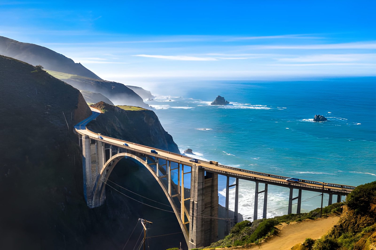
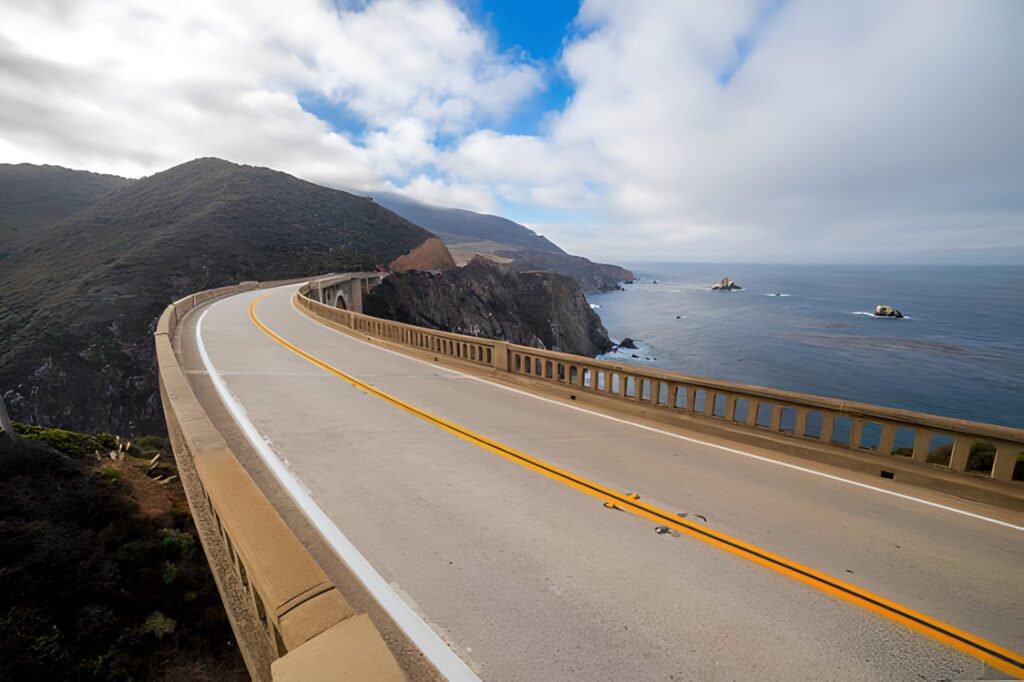
Bixby Creek Bridge (Mile 307)
Big Sur’s most photographed structure—graceful concrete arch spanning Bixby Creek Canyon 260 feet above creek, completed 1932 as engineering marvel. Castle Rock Viewpoint (north side, small parking area) provides the classic shot everyone takes.
Traffic moves fast here despite curves—pulling out requires care. Many people park at viewpoint, walk back across bridge for different angles. The bridge itself is beautiful; its setting against cliffs and ocean makes it iconic.
Point Sur Lighthouse (Mile 312)
Perched on 361-foot volcanic rock jutting into ocean, Point Sur Light Station operated 1889-1974. Now you can tour it (reservations required, $20, tours Wed/Sat/Sun seasonally) via guided 3-hour walk covering 0.5 miles and climbing 400 stairs. It’s moderate challenge but rewards with lighthouse interior access and 360-degree views.
Tours leave from Point Sur State Historic Park parking area. Check schedule online, book ahead. Worth it for lighthouse fans and those wanting insider Big Sur access.
Garrapata State Park (Mile 320)
Actually two disconnected sections—Garrapata Beach on ocean side (multiple coves accessed via short trails, dramatic surf crashes on rocks, cold water but spectacular scenery) and Garrapata Highlands inland side (hiking with ocean views through coastal scrub).
Soberanes Point Trail (2 miles, moderate) leads to rocky promontory jutting into ocean—excellent whale watching (December-April). Rocky Ridge Trail (4.5 miles, challenging) climbs to elevated views encompassing coast and inland mountains. Beach access requires caution—sneaker waves and strong currents make swimming dangerous. Come for views, tide pools, and hiking rather than beach day.
Monterey Peninsula (Miles 330-375)
Carmel-by-the-Sea (Mile 330)
Fairytale village of 3,800 residents where no addresses exist (houses identified by block and building names), no high heels on sidewalks without permits (archaic unenforced law), and no chain stores allowed. Carmel Beach provides white sand backed by cypress trees—walk south at low tide for optimal conditions.
Downtown Carmel packs galleries, boutiques, restaurants, and tasting rooms into walkable blocks. Ocean Avenue leads directly to beach. Browse, eat, and wander—the village itself is the attraction. Point Lobos State Natural Reserve (3 miles south, $10 day use) showcases Big Sur-caliber scenery in compact, accessible park. The Cypress Grove Trail, Sea Lion Point Trail, and China Cove deliver spectacular coastline, tide pools, and potential whale watching (December-May).
17-Mile Drive (Pebble Beach) (Mile 332)
This famous scenic road through Pebble Beach costs $11.50 per vehicle but delivers consistent ocean views, golf courses, and Lone Cypress—California’s most photographed tree (260 years old, clinging to rocky point). The drive includes Bird Rock (sea lion watching), Spanish Bay, and multiple beaches.
Allow 1-2 hours driving plus stops. While commercialized and expensive, the scenery and iconic status justify experiencing once. Bikes enter free—consider cycling if fit enough for hills.
Monterey (Mile 340)
Cannery Row, immortalized by John Steinbeck, transformed from sardine canning center to tourist district—shops, restaurants, and the Monterey Bay Aquarium ($60 adults, advance tickets required especially summer). The aquarium ranks among world’s best with two-story kelp forest exhibit, sea otter feeding, jellyfish galleries, and interactive touch pools. Allow 2-3 hours minimum.
Monterey State Historic Park preserves 19th-century adobe buildings and Custom House (California’s oldest government building). Walk the Path of History (2-mile loop, markers explain significance of each building) learning about Spanish, Mexican, and early American California.
Monterey Bay Coastal Recreation Trail provides 18 miles of paved, mostly flat cycling/walking along the bay from Castroville through Monterey to Pacific Grove—rent bikes and ride sections sampling the bay’s beauty without highway traffic.
Pacific Grove (Mile 345)
This quaint town calls itself “America’s Last Hometown”—Victorian houses, Lovers Point Beach, and the Monarch Butterfly Sanctuary (October-February, free) where thousands of Monarchs cluster in eucalyptus grove. Walk the Ocean View Boulevard coastal path watching for sea otters (common here) and enjoying ocean vistas.
Point Pinos Lighthouse (1855, oldest continuously operating lighthouse on West Coast, $5 tours Thu-Mon) provides maritime history. Downtown Pacific Grove offers antique shops, cozy restaurants, and small-town charm contrasting Carmel’s sophistication and Monterey’s tourism.
Northern Section: Santa Cruz to San Francisco (75 Miles)
Santa Cruz (Mile 370)
The Santa Cruz Beach Boardwalk (free admission, ride tickets required) ranks as California’s oldest amusement park (1907) with vintage wooden Giant Dipper roller coaster (National Historic Landmark). It’s touristy but genuinely fun—walk the boardwalk, ride a few rides, eat corn dogs, embrace the retro beach town energy.
Steamer Lane provides world-class surf watching—perch on cliffs watching expert surfers tackle challenging break. Natural Bridges State Beach features rock arch (partially collapsed but still scenic), tide pools, and Monarch butterfly grove (October-February).
Downtown Santa Cruz mixes college town (UC Santa Cruz) with beach culture creating eclectic vibe—bookstores, coffee shops, locally-owned restaurants. Marianne’s Ice Cream serves outstanding ice cream in massive portions.
Capitola (Mile 373)
Tiny beach town with Mediterranean-influenced architecture surrounding Capitola Beach and Esplanade—waterfront path lined with restaurants and shops. The painted houses, small scale, and genuine charm make Capitola feel like discovering a secret (though locals know it well). Walk the Esplanade, eat at Zelda’s on the Beach (overpriced but great location), and simply enjoy the mellow atmosphere.
Aptos & Seacliff State Beach (Mile 376)
Seacliff State Beach features the concrete ship Palo Alto—built 1919, intentionally grounded 1930 as fishing pier/amusement park, now deteriorated but still visible from shore. Walk the pier out to the ship remains photographing this unusual maritime oddity.
Aptos provides access to Forest of Nisene Marks State Park (10,000 acres of redwood forest with hiking) if you need forest immersion break from constant ocean views.
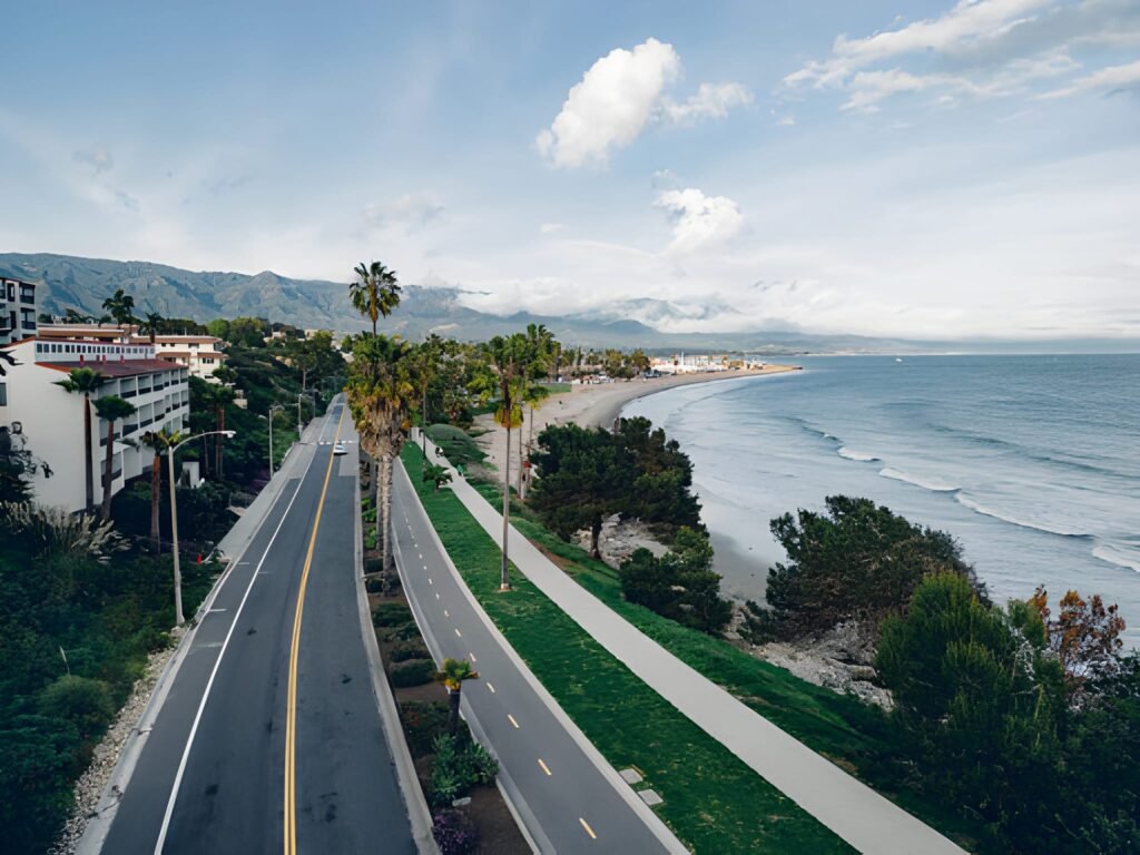
Half Moon Bay (Mile 400)
Charming coastal town 25 miles south of San Francisco combining agriculture (pumpkin farms, nurseries) with beach culture. Main Street hosts shops, galleries, and excellent restaurants in historic buildings.
Half Moon Bay Beaches (multiple state beaches connected by coastal trail) provide wild, windswept coastline perfect for walking, tide pools, and surf watching—too cold for swimming most times but spectacular scenery. Mavericks (offshore near Pillar Point Harbor) produces legendary big-wave surf in winter—waves reach 60+ feet attracting expert surfers worldwide. Watch from shore at Pillar Point Harbor or Mavericks Beach but never attempt swimming here (deadly currents).
Sam’s Chowder House at harbor serves excellent seafood with harbor views. Pasta Moon downtown provides Italian in cozy atmosphere. Pumpkin Festival (October) draws massive crowds—avoid this weekend unless specifically coming for it.
Pacifica (Mile 415)
San Francisco’s southern neighbor offers rugged coastline and surf culture. Devil’s Slide Trail (1.3 miles, easy, paved) follows former Highway 1 alignment (replaced by tunnel 2013) providing coastal walking with consistent ocean views—accessible, beautiful, and popular with locals.
Pacifica Pier juts into surf attracting fishermen. Tide pools, beaches, and the Pacifica Beach Coalition create community-focused coastal access. It’s transitional zone between sleepy coast and San Francisco’s urban energy.
San Francisco (Mile 430)
Highway 1 enters San Francisco via Golden Gate Bridge—drive across or park at Battery Spencer (Marin Headlands, north side) for iconic bridge views with city backdrop. Baker Beach (south of bridge) provides beach-level bridge views.
San Francisco warrants days of exploration—Fisherman’s Wharf, Alcatraz (book weeks ahead), Golden Gate Park, Chinatown, cable cars, and neighborhoods like Mission, Haight-Ashbury, and North Beach. While not Highway 1’s focus, the city marks significant milestone for PCH travelers.
Leaving north from San Francisco, Highway 1 splits from 101 heading up coast through Muir Woods (towering redwoods, reservations required for parking), Stinson Beach, Point Reyes National Seashore, and eventually Mendocino—covered briefly below.
Far Northern Section: Mendocino Coast (Miles 500-655)
Mendocino (Mile 545)
Victorian village perched on bluffs resembles New England more than California—white picket fences, water towers, and 19th-century architecture preserved through strict planning. Mendocino Headlands State Park (free) surrounds village with clifftop trails, blowhole views, and sea cave exploration.
Art galleries, B&Bs, and locally-owned shops dominate. It’s quiet, sophisticated, and remote—perfect for those seeking solitude and natural beauty without crowds. Cafe Beaujolais serves exceptional French-California cuisine, Mendocino Hotel offers Victorian charm, and walking the headlands at sunset provides magnificent isolation.
Fort Bragg & Glass Beach (Mile 555)
Working-class fishing town contrasts Mendocino’s gentrification. Glass Beach (three locations, main one near Elm Street) showcases decades of dumped glass worn smooth by waves—colorful “sea glass” covers beaches creating unusual landscape. Taking glass is prohibited but photography encouraged.
Mendocino Coast Botanical Gardens (47 acres, $20) stretch from highway to bluffs with cultivated gardens, coastal trails, and rhododendron displays (peak April-May). Noyo Harbor south of town provides working harbor atmosphere with fish markets and seafood restaurants.
Point Arena Lighthouse (Mile 590)
California’s tallest lighthouse (115 feet, tours daily, $10) offers 360-degree views after climbing 145 steps. The museum explains maritime history, and Point Arena’s remote beauty justifies the stop if you’re completing full Highway 1.
Leggett (Mile 655) – Highway 1 Terminus
Highway 1 officially ends (or begins) at intersection with Highway 101 in tiny Leggett. The Chandelier Drive-Thru Tree nearby ($10 per vehicle) lets you drive through a carved redwood—touristy but fun photo op completing (or starting) your PCH journey.
Essential PCH Road Trip Planning Tips
Gas Strategy: Fill up whenever you see stations under $5.50/gallon (rare). Big Sur has limited gas ($7-8/gallon typical), Cambria, Morro Bay, and Monterey offer reasonable prices. Never let tank drop below 1/4 full.
Cell Service: Expect zero service Big Sur, spotty Mendocino, generally good elsewhere. Download offline maps for entire route. Emergency call boxes exist every few miles on Big Sur section.
Accommodations: Book 4-6 weeks ahead for Big Sur (limited rooms, high demand). Elsewhere 2-4 weeks suffices except holidays. Budget $150-400/night depending on location and season.
Weather: Pack layers. Coastal fog burns off afternoon; mornings stay cool year-round. Windbreaker essential. Summer fog often obscures views until 11 AM-1 PM.
Food: Restaurants cluster in towns; long stretches (especially Big Sur) offer nothing. Pack snacks, water, and picnic supplies. Many scenic spots perfect for picnicking.
Safety: Highway 1 includes narrow sections, steep drop-offs, and blind curves. Drive defensively, pull over for faster traffic, and never stop in traffic lanes for photos. Cliff edges often lack barriers—stay back from unstable edges.
Timing: Allow 45-60 minutes per driving hour for stops. A “5-hour drive” becomes 8-10 hours realistically. Don’t over-schedule—missed stops beat exhausted driving.
Frequently Asked Questions
How long does it take to drive the Pacific Coast Highway?
The full 655 miles requires minimum 5-7 days to properly experience key stops, though you could drive it in 3-4 days hitting only major highlights. Most travelers focus on specific sections: Malibu to Carmel (3-4 days), Big Sur only (2 days), or San Francisco to Mendocino (2-3 days). Pure driving time without stops runs about 17 hours, but stopping every 30 minutes for views, food, and exploration means actual travel time triples.
What’s the best time of year to drive Pacific Coast Highway?
Spring (April-May) and fall (September-October) provide ideal conditions with clear weather, smaller crowds, and moderate temperatures. Summer brings peak crowds and frequent morning fog but longest daylight and warmest weather. Winter offers solitude and dramatic storms but risks road closures from landslides and reduced business hours. Avoid holiday weekends and Big Sur in July-August if possible.
Should I drive north to south or south to north?
Most experts recommend south to north (San Diego area toward San Francisco) because you drive in the lane closest to ocean views with easiest pullout access, the sun stays behind you rather than in your eyes, and traffic flows lighter northbound. However, both directions provide spectacular views—choose based on your starting point rather than obsessing over direction.
Is the Pacific Coast Highway dangerous to drive?
Highway 1 includes narrow sections, steep cliff drop-offs, blind curves, and sometimes aggressive drivers, but it’s not inherently dangerous if you drive cautiously. Maintain safe speeds (25-40 mph in Big Sur), pull over for faster traffic, never stop in traffic lanes for photos, and respect that many sections lack guardrails. Weather creates more danger than the road itself—rain makes curves slippery and fog reduces visibility to near-zero. Check conditions before driving and postpone in severe weather.
Where should I stay overnight on a Pacific Coast Highway road trip?
For 5-7 day trips, consider: Night 1 – Santa Barbara or Malibu; Night 2 – Cambria or San Simeon; Night 3-4 – Big Sur (expensive, limited rooms) or Carmel; Night 5 – Monterey or Santa Cruz; Night 6 – Half Moon Bay or San Francisco. This pacing prevents exhaustion while positioning you near major stops. Book Big Sur 6-8 weeks ahead; elsewhere 3-4 weeks suffices except peak season/holidays.
Can you do Pacific Coast Highway in 3 days?
Yes, but expect long driving days and limited stop time. A realistic 3-day itinerary: Day 1 – Malibu to Cambria (5-6 hours); Day 2 – Cambria to Carmel including Big Sur (6-7 hours); Day 3 – Carmel to San Francisco (3-4 hours). You’ll hit major stops but miss countless smaller gems. Better: extend to 5 days or focus on shorter section (Big Sur + Monterey Peninsula in 2-3 days provides more satisfying experience).
What’s the most scenic part of Pacific Coast Highway?
Big Sur (miles 260-350) unanimously wins for dramatic cliffs, waterfalls, and iconic bridges. However, Mendocino offers different beauty with Victorian charm and rugged headlands, Monterey Peninsula combines coastal scenery with charming towns, and even Southern California stretches through Laguna Beach and Malibu provide spectacular views. “Most scenic” depends on personal preference—I’d never skip Big Sur, but I also love Mendocino’s isolation and Monterey’s variety.
Key Takeaways: Making Your Pacific Coast Highway Journey Unforgettable
Pacific Coast Highway isn’t a destination—it’s 655 miles of destinations connected by California’s most beautiful road. Success requires abandoning efficiency mindset and embracing wandering. That unexpected beach, the unmarked trail, the roadside oyster shack you stumble upon—these unplanned stops often become favorite memories.
The stops catalogued above represent proven highlights, but Highway 1 holds hundreds more. Watch for pullouts where locals gather—they know something. Stop when views captivate you, not just at designated viewpoints. Eat at cafes locals fill, not just tourist traps with prime locations. Talk to people—winemakers, shopkeepers, other travelers—about their favorite spots. The best PCH experiences come from curiosity and flexibility, not rigid itineraries.
Budget more time than you think necessary. Most travelers underestimate how long this drive actually takes and end up stressed, rushing past places that deserve lingering. Three extra hours in your schedule means the difference between frustrated hurrying and relaxed meandering.
Start planning your Pacific Coast Highway adventure by choosing your section based on time available and interests. Beach lovers prioritize Southern California and Santa Barbara. Nature enthusiasts head straight to Big Sur. Foodies and wine lovers linger around Monterey Peninsula and Cambria with wine country access. Small-town charm seekers explore Mendocino and Fort Bragg.
Book accommodations first (especially Big Sur), then build your stops around where you’re sleeping. Download offline maps, pack layers, fill up gas tanks proactively, and remember that the journey itself matters more than reaching any particular destination. California’s Pacific Coast Highway rewards those who slow down, pull over often, and let the road surprise them.
Your Highway 1 adventure awaits—possibly the most beautiful drive you’ll ever experience, definitely one you’ll never forget. Safe travels, stop often, and soak in every magnificent mile of this legendary route.
