
I’m standing at the McWay Falls overlook at 7:30 AM, watching morning fog lift off an 80-foot waterfall that cascades onto an untouched beach, when a couple asks me if they can actually walk down to that perfect crescent of sand. After driving Highway 1 through Big Sur seventeen times over the past eight years—through closures, fog, wildfires, and perfect blue-sky days—I’ve learned that Big Sur rewards those who understand its rhythms and realities.
Most Big Sur guides list the same five stops without explaining the parking nightmare at McWay Falls, when waterfalls actually flow, or how to navigate the ongoing Highway 1 closures that have confused travelers since 2023. This complete guide provides 25 tested Big Sur activities with specific parking strategies, timing advice, current road closure information, and honest assessments of what’s worth your time versus what’s overhyped. Whether you’re planning a day trip from Monterey or a multi-day coastal adventure, you’ll find everything you need to experience Big Sur’s dramatic coastline, towering redwoods, and hidden beaches without the frustration most first-time visitors encounter.
Understanding Big Sur Before You Go
Big Sur isn’t a town—it’s a 90-mile stretch of California’s Central Coast where the Santa Lucia Mountains plunge dramatically into the Pacific Ocean. The region extends roughly from Carmel south to San Simeon, connected by the iconic Highway 1, also known as the Pacific Coast Highway.
Here’s what catches most visitors off guard: Highway 1 through Big Sur has been partially closed since February 2024 due to Regent’s Slide, a massive landslide 40 miles south of Carmel. Caltrans expects the road to fully reopen by March 2026, but this closure has actually created something unexpected—less crowded access to Big Sur’s northern and southern sections. You can still experience the best of Big Sur from either direction; you just can’t drive the entire 90-mile stretch through.
Cell service is virtually nonexistent throughout Big Sur. Download offline maps before you arrive, carry a physical map as backup, and plan to be unreachable for several hours. Gas stations are sparse and expensive—fill up in Carmel if approaching from the north or in Cambria if coming from the south.
The weather here operates on its own schedule. Mornings typically bring dense fog that burns off by midday, and temperatures can swing 20 degrees between the coast and just a mile inland. Layers are essential year-round.
Quick Reference: Big Sur Essentials
| Category | Details |
|---|---|
| Best Time to Visit | April-May (waterfalls flowing, wildflowers) or September-October (clearest weather, fewer crowds) |
| Ideal Trip Length | 2-3 days to see highlights; 4-5 days to explore thoroughly |
| Current Access | Northern section accessible from Carmel; southern section accessible from Cambria (6.8-mile closure at Regent’s Slide through March 2026) |
| Entry Fees | $10 per vehicle at state parks (cash preferred; California State Parks Pass accepted) |
| Cell Service | None in most areas—download maps offline |
| Gas Stations | Limited; fill up before entering Big Sur |
| Parking Reality | Arrives early (before 9 AM) at popular spots like McWay Falls and Pfeiffer Beach |
The Best Things to Do in Big Sur
Iconic Stops You Actually Shouldn’t Miss
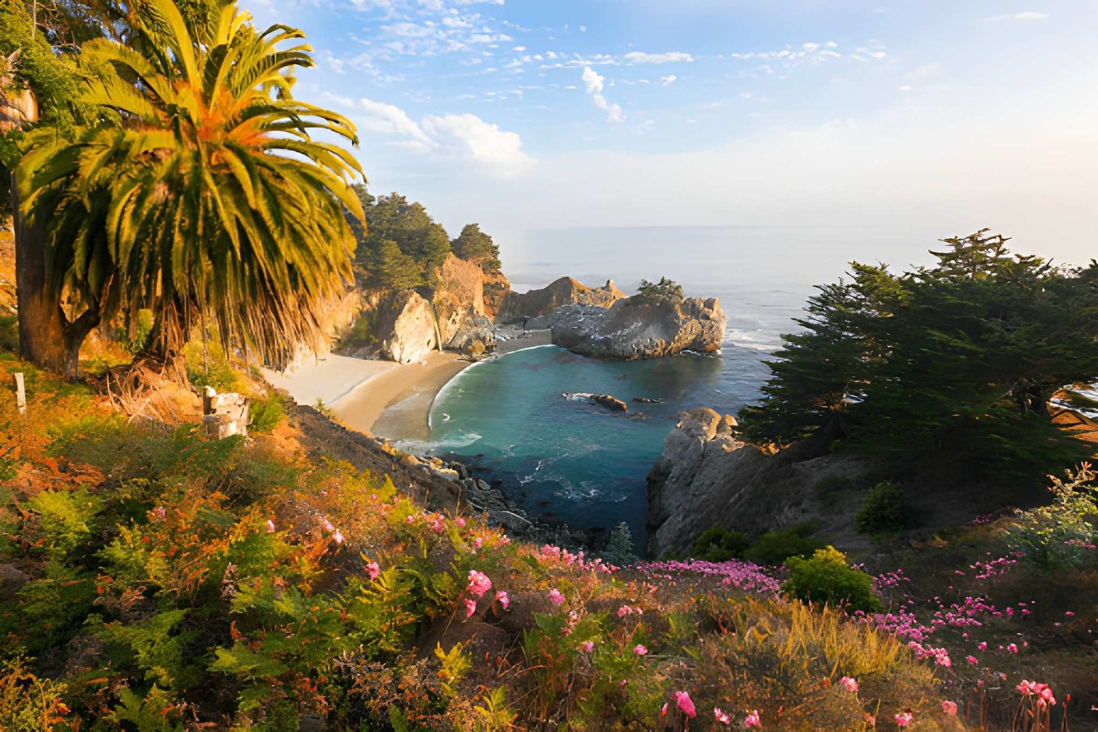
1. McWay Falls at Julia Pfeiffer Burns State Park
This is Big Sur’s postcard image for good reason—an 80-foot waterfall dropping directly onto a pristine beach surrounded by turquoise water. Unlike most travel photos that promise more than they deliver, McWay Falls exceeds expectations.
The half-mile trail from the parking lot to the overlook is paved and mostly flat, passing through a short tunnel under Highway 1 before reaching multiple viewpoints. You cannot access the beach below—it’s protected and inaccessible—but the elevated perspective makes the scene even more dramatic.
Parking Strategy: The lot holds maybe 40 cars and fills by 9 AM on weekends and summer weekdays. Arrive by 8 AM or after 4 PM. If full, drive past and return later; roadside parking is prohibited and tickets are expensive. Turnover happens quickly since most visitors spend only 30-45 minutes here.
Best Time: Afternoon light (2-5 PM) illuminates the cove beautifully. Overcast days actually enhance the turquoise water color. Winter and spring offer the strongest waterfall flow; by late summer it sometimes reduces to a trickle.
Cost: $10 per vehicle park entry fee (pay at self-serve kiosk; cash strongly recommended)
Time Needed: 45 minutes to 1 hour
Insider Tip: Walk the Ewoldsen Trail on the inland side of Highway 1 (same parking lot) for a completely different Big Sur experience through redwood groves with coastal overlooks—almost nobody does this, so you’ll have it mostly to yourself.
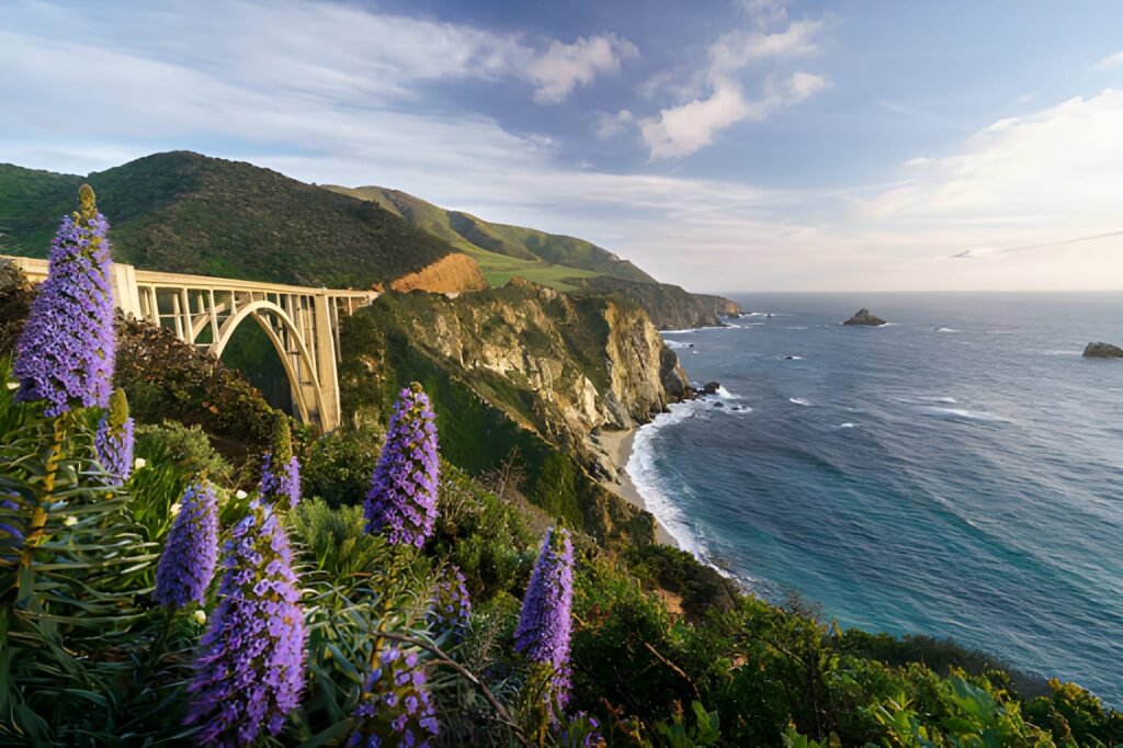
2. Bixby Bridge
This 714-foot concrete arch bridge, completed in 1932, is Big Sur’s most photographed landmark. Crossing it while driving is impressive; viewing it from the north side is spectacular.
The designated vista point sits on the north side of the bridge on the ocean side of Highway 1. Pull into the dirt parking area (it’s larger than it looks—about 30 spaces) and walk to the edge for the classic view of the bridge arching over Bixby Creek Canyon with the Pacific beyond.
Parking Strategy: This lot fills mid-morning but has faster turnover than McWay Falls since most people stop for 10-15 minutes. If full, continue 0.3 miles north to the Old Coast Road parking area for an alternate view.
Best Time: Late afternoon (3-6 PM) for the best lighting on the bridge’s arch. Fog often obscures morning views.
Cost: Free
Time Needed: 15-30 minutes
What to Skip: Don’t attempt to walk on the bridge itself—the shoulder is narrow and dangerous with traffic. The photo opportunity from the vista point is superior anyway.
3. Pfeiffer Beach
Big Sur’s only easily accessible beach features dramatic purple sand (from manganese garnet in the surrounding rocks), towering rock formations, and the famous Keyhole Arch where waves crash through during high tide.
Finding it challenges most visitors since it’s not well-marked. From Highway 1, turn onto Sycamore Canyon Road (look for the only stoplight in Big Sur at Pfeiffer Big Sur State Park; Sycamore Canyon Road is one mile south). Follow this narrow, winding road 2.1 miles to the beach parking lot.
Parking Strategy: The lot holds about 60 cars and fills by 11 AM on nice weekends. Arrive before 10 AM or after 3 PM. The road is too narrow for turnarounds, so if the lot is full, you must drive all the way to the end, turn around, and leave—frustrating after that winding descent.
Best Time: Two hours before sunset for the Keyhole Arch photo when light streams through the arch opening. Winter brings the strongest waves crashing through. Purple sand is most visible when wet.
Cost: $10 self-serve entry fee (cash only)
Time Needed: 1-2 hours
Safety Note: Rip currents are dangerous here—wading is fine, but swimming is risky. Sneaker waves can surprise beachgoers; never turn your back on the ocean.
Hiking Adventures
4. Ewoldsen Trail Loop
This 4.6-mile loop in Julia Pfeiffer Burns State Park delivers everything Big Sur promises—coastal redwood forests, canyon views, ridge-top ocean panoramas, and relative solitude. It’s the best moderate hike in Big Sur that most visitors never attempt because they stop at McWay Falls and leave.
The trail climbs steadily through McWay Canyon, gaining 1,600 feet of elevation. You’ll pass through towering redwoods, cross wooden bridges, and eventually reach ridgetop viewpoints at 1,400 feet elevation overlooking the coast. The loop can be hiked in either direction; I prefer counterclockwise to get the climbing done early.
Trailhead: Same parking lot as McWay Falls—cross Highway 1 to the inland side to start
Difficulty: Moderate to challenging; steady elevation gain with some steep sections
Time Needed: 3-4 hours
Best Season: Spring (March-May) for flowing creeks and wildflowers; summer for the clearest coastal views
What to Bring: Water (no refills available), layers (temperatures change with elevation), camera for ridge-top views
5. Pfeiffer Falls Trail
An easy 1.6-mile round-trip hike through Pfeiffer Big Sur State Park leads to a 60-foot waterfall in a lush canyon. This is Big Sur’s most accessible waterfall hike and perfect for families or anyone wanting a taste of the redwood forest without serious elevation gain.
The well-maintained trail follows Pfeiffer Redwood Creek through a canyon filled with massive redwoods, ferns, and sorrel. The waterfall flows year-round but peaks in winter and spring—by late summer it’s modest. A viewing platform provides the best vantage point.
Trailhead: Pfeiffer Big Sur State Park day-use area (clearly marked from Highway 1)
Difficulty: Easy; 300 feet of elevation gain on a well-maintained trail
Time Needed: 1-1.5 hours
Cost: $10 per vehicle park entrance fee
Insider Tip: Combine this with the nearby Valley View Trail (also in Pfeiffer Big Sur State Park) for a 2-mile loop with excellent views of the Big Sur Valley and coastline. Almost nobody does this extension despite it being stunning.
6. Partington Cove Trail
This 1-mile round-trip hike leads to a hidden cove through a hand-carved tunnel blasted into the rock in the 1880s. It’s one of Big Sur’s best-kept secrets despite being right off Highway 1.
Park in the small pullout on the ocean side of Highway 1 at milepost 37.3 (look for “Partington Creek” on older maps or GPS). The trail descends steeply through redwoods and ferns for 0.5 miles to a rocky beach. The highlight is the 60-foot tunnel carved through solid rock that was once used to load lumber onto ships.
Parking: Room for 4-5 cars in the small turnout; if full, you’ll need to continue and return later
Difficulty: Moderate; steep descent means a steep climb back up
Time Needed: 45 minutes to 1 hour
Best Time: Low tide for beach exploration; high tide brings waves crashing into the cove dramatically
Local Knowledge: The cove faces west, making it spectacular at sunset. Few people know about this spot, so even on busy Big Sur days, you might have it to yourself.
7. Andrew Molera State Park Headlands Trail
This 2.5-mile loop offers Big Sur’s best accessible beach walking, whale watching spots, and wildflower meadows. Andrew Molera State Park protects a massive expanse of coastline and mountains, and this trail showcases the variety.
From the parking area, walk 0.3 miles to the beach, then take the Headlands Trail up to the bluff top. You’ll pass through grassland meadows (brilliant with wildflowers in spring), climb to promontories perfect for whale watching (December-April), and look down on river-mouth beaches.
Parking: Large lot at park entrance
Difficulty: Easy to moderate; mostly flat with one moderate climb
Time Needed: 1.5-2 hours for the loop; add time for beach relaxing
Cost: $10 per vehicle
Best Season: April-May for wildflowers and gray whale migration
Wildlife: Watch for sea otters in kelp beds near the beach, hawks overhead, and possibly gray whales offshore during migration season.
State Parks and Natural Wonders
8. Point Lobos State Natural Reserve
Located just south of Carmel where Big Sur begins, Point Lobos protects one of the richest marine habitats in California. This is Big Sur’s most accessible state park and offers the best combination of easy hiking, wildlife viewing, and coastal beauty.
Six miles of trails wind through cypress groves, along cliff-top paths, and down to hidden coves. The Cypress Grove Trail showcases ancient Monterey cypress trees clinging to granite cliffs. China Cove offers turquoise water that rivals anything in Hawaii. Bird Island Trail provides excellent sea lion viewing.
Parking Strategy: The reserve has limited parking and fills early on weekends. Reservations are now required on weekends and holidays through Reserve California—book 2-3 weeks ahead. Weekdays remain first-come, first-served.
Cost: $10 per vehicle
Time Needed: 2-4 hours to experience multiple trails and coves
Best Time: Early morning (7-9 AM) for the best light and wildlife activity; weekday afternoons for smaller crowds
Wildlife: Sea otters, harbor seals, sea lions, gray whales (winter/spring), pelicans, cormorants
Insider Tip: The less-traveled south shore trails offer equally stunning views without the crowds that cluster around China Cove and Bird Island.
9. Garrapata State Park
This underutilized park just north of the main Big Sur area offers excellent coastal hiking and the famous Calla Lily Valley. Most Big Sur visitors blow past it heading to McWay Falls, which means better experiences for those who stop.
The Soberanes Point Trail provides dramatic cliff-top walking with excellent whale watching. Garrapata Beach below offers tide pooling and sunset views. In late February through mid-March, thousands of wild calla lilies bloom in a small valley reached by a short trail—this attracts photographers but remains less crowded than Big Sur’s famous stops.
Parking: Several dirt pullouts along Highway 1; park at Gate 18 for Soberanes Point trails or Gate 19 for beach and lily valley access
Cost: Free (no entrance fee)
Difficulty: Moderate; coastal trails involve elevation gain and rough terrain
Time Needed: 2-3 hours
Calla Lily Season: Mid-February to mid-March (check conditions before going specifically for this)
Safety: Trails are less maintained than other state parks; watch for poison oak and uneven terrain
10. Limekiln State Park
This 711-acre park combines everything that makes Big Sur special: coastal views, redwood forests, waterfalls, and historic lime kilns from the 1880s. It’s less visited than Pfeiffer Big Sur State Park despite offering equally impressive features.
The Limekiln Trail leads 0.8 miles to four historic lime kilns and continues to a forked waterfall in a lush redwood canyon. The coastal camping area provides direct beach access. This park successfully balances history, nature, and coastal beauty in a compact area.
Parking/Camping: Day-use parking available; camping reservations recommended through Reserve California
Cost: $10 day use; $35-50 per night for camping
Time Needed: 2-3 hours for hiking to kilns and waterfall
Best Season: Winter and spring for strongest waterfall flow
Camping Appeal: The campsites here sit right along the creek under redwoods with beach access—some of Big Sur’s best camping without the crowds of Pfeiffer Big Sur State Park.
Beaches and Coastal Access
11. Sand Dollar Beach
Big Sur’s longest sandy beach offers the best accessible beach walking and picnicking in the southern Big Sur area. Unlike many Big Sur beaches that are rocky or hard to reach, Sand Dollar Beach provides easy access to a genuine sand beach.
A short paved trail descends from the parking area to the beach. The crescent-shaped beach stretches for about a mile, backed by dramatic cliffs. It’s popular with surfers at the south end where a reef creates rideable waves.
Location: Highway 1, 11 miles south of Lucia
Parking: Large parking area; rarely fills
Cost: $10 per vehicle
Time Needed: 1-2 hours
Best For: Beach walks, picnics, watching surfers, sunset viewing
Swimming: Cold and rough; better for wading than swimming
Accessibility: More accessible than most Big Sur beaches; paved trail to beach level
12. Jade Cove
This rocky cove earned its name from jade deposits found in the rocks and along the beach. Jade hunting has become popular here, though finding actual jade requires knowledge, patience, and luck.
The trail down to the cove is steep and rough—about 0.5 miles with significant elevation drop. The beach is rocky and the waves powerful. Come for the scenery and dramatic coastal setting more than the slim chance of finding jade.
Location: Highway 1, 0.7 miles south of the Plaskett Creek Campground
Parking: Small pullout on ocean side
Difficulty: Moderate to challenging; steep, unmaintained trail
Time Needed: 1-1.5 hours
Best Time: Low tide for beach access
Reality Check: Finding valuable jade is rare despite the name. Enjoy this as a scenic cove with interesting geology rather than a treasure hunt.
Unique Experiences
13. Henry Miller Memorial Library
This cultural center celebrates writer Henry Miller, who lived in Big Sur from 1944-1962 and made it famous through his books. It’s part bookstore, part art gallery, part performance space, and completely unique to Big Sur.
The library sits in a redwood-shaded building that was once home to Miller’s friend Emil White. Browse books, check out rotating art exhibits, or relax in the garden. The library hosts concerts, film screenings, and literary events—check their schedule if your visit coincides with an event.
Location: Highway 1, 0.25 miles south of Nepenthe restaurant
Hours: Wednesday-Monday, 11 AM-6 PM (closed Tuesdays)
Cost: Free admission; donations welcomed
Time Needed: 30 minutes to 1 hour
Special Events: The library hosts top indie musicians, authors, and artists—performances in this intimate Big Sur setting are memorable
Why Visit: It captures Big Sur’s artistic, bohemian spirit better than anywhere else in the region
14. Point Sur Lightstation
This 1889 lighthouse sits on a volcanic rock 361 feet above the ocean. The only access is through guided tours that climb the steep path to the lighthouse and share the keepers’ stories.
Three-hour tours run on weekends (schedule varies by season). The climb is strenuous with over 300 stairs and steep paths, but the views from the top are extraordinary. You’ll see the lighthouse operations, keepers’ quarters, and learn about the Coast Guard families who lived in this isolated spot.
Location: Highway 1, 19 miles south of Carmel
Hours/Tours: Weekends only; check website for current schedule and reservations
Cost: $15 adults, $5 children (12 and under)
Difficulty: Strenuous; 300+ stairs and steep trails
Time Needed: 3 hours for complete tour
Book Ahead: Tours often sell out, especially on nice-weather weekends
Worth It For: History enthusiasts, lighthouse lovers, those seeking incredible coastal views
15. Nepenthe Restaurant
This iconic Big Sur restaurant has been serving travelers since 1949 from its perch 808 feet above the Pacific. Come for the views as much as the food—floor-to-ceiling windows and outdoor terraces overlook 40 miles of coastline.
The restaurant occupies land once owned by Orson Welles and Rita Hayworth. The Ambrosia Burger has become legendary among Big Sur regulars. Prices are high ($18-45 for entrees), but you’re paying for one of California’s most spectacular restaurant locations.
Location: Highway 1, 30 miles south of Carmel
Hours: Daily 11:30 AM-10 PM (hours vary by season)
Budget: $25-50 per person for lunch; $50-85 for dinner
Parking: Large lot but fills midday on weekends; arrive before noon or after 2 PM
Insider Tip: The more casual Café Kevah next door (owned by the same family) offers similar views with lighter food and lower prices—breakfast and lunch only
Best Time: Sunset dinner reservations or late lunch (2-4 PM) when the lunch rush clears
Waterfalls Worth Visiting
16. Salmon Creek Falls
This 100-foot waterfall drops dramatically onto the beach where Salmon Creek meets the Pacific. It’s unique among California waterfalls for flowing directly onto a beach, and unlike McWay Falls, you can walk right up to it.
The short trail from the parking area on Highway 1 is easy and takes about 10 minutes. The waterfall flows strongest in winter and spring following rains—by late summer it can reduce significantly or dry up entirely. High surf and king tides sometimes send ocean waves into the waterfall area, creating dramatic collisions of fresh and saltwater.
Location: Highway 1, 7 miles south of Ragged Point
Parking: Small dirt pullout on ocean side of Highway 1
Difficulty: Easy; short walk from highway
Time Needed: 30-45 minutes
Best Season: December through May for strongest flow
Photography: Afternoon light is best; high tide during winter creates dramatic wave/waterfall interactions
17. Limekiln Falls
Hidden in the redwood forest of Limekiln State Park, this unique forked waterfall offers a completely different experience from Big Sur’s coastal waterfalls. The trail to reach it passes the historic lime kilns and winds through old-growth redwood groves.
The 1.6-mile round-trip trail is mostly flat and family-friendly. The waterfall splits into two streams that cascade over moss-covered rocks in a setting that feels more Pacific Northwest than California coast. It flows year-round but peaks in winter and spring.
Location: Limekiln State Park (see park entry above for details)
Difficulty: Easy; mostly flat trail
Time Needed: 1 hour
Cost: $10 day-use park fee
Best Time: Morning for best forest light; winter/spring for strongest flow
Camping and Overnight Stays
18. Pfeiffer Big Sur State Park Campground
Big Sur’s most developed campground offers 189 campsites in a redwood forest along the Big Sur River. It’s the most convenient base for exploring northern Big Sur attractions, though it’s also the most crowded and least peaceful of Big Sur’s camping options.
Sites range from basic tent spots to RV sites (trailers under 27 feet only due to narrow park roads). The campground provides restrooms, hot showers, and a camp store. Trails to Pfeiffer Falls and Valley View start from the campground.
Reservations: Essential, especially April-October; book 6 months ahead through Reserve California
Cost: $35-50 per night depending on site
Amenities: Flush toilets, hot showers, picnic tables, fire rings, camp store
Pros: Central location, easy access to trails, hot showers
Cons: Crowded, limited privacy between sites, can feel like a campground city in summer
Best For: Families, first-time Big Sur visitors, those wanting amenities
19. Kirk Creek Campground
This smaller USFS campground sits on bluffs directly above the ocean in southern Big Sur. It lacks the amenities of Pfeiffer Big Sur but offers something more valuable—ocean views from your tent and the sound of waves all night.
The 33 sites perch on coastal bluffs with some offering direct ocean views. Facilities are basic: vault toilets, picnic tables, fire rings. No showers, no camp store, no frills—just you and the Pacific Ocean with some of California’s most dramatic coastal camping.
Reservations: First-come, first-served for most sites; some reservable through Recreation.gov
Cost: $35 per night
Amenities: Vault toilets, picnic tables, fire rings (no showers, no hookups)
Pros: Ocean views, fewer people, more peaceful than Pfeiffer
Cons: No amenities, exposed to wind and weather
Best For: Experienced campers seeking the true Big Sur coastal experience
Insider Tip: Sites 1, 3, 4, and 5 have the best ocean views—these fill first on walk-up days
Scenic Drives and Viewpoints
20. Hurricane Point Vista
This pullout offers perhaps the most expansive coastal view in Big Sur—on clear days you can see 50 miles of coastline stretching south toward San Luis Obispo. It’s named for the strong winds that often batter this exposed point.
The vista point sits at a large paved turnout on the ocean side of Highway 1, about 11 miles south of Carmel. From 750 feet above the ocean, you’ll see Bixby Bridge to the north, endless coastline to the south, and the Santa Lucia Mountains rising inland. On clear winter and spring days, you might spot gray whale spouts offshore.
Location: Highway 1, milepost 60.7
Parking: Large paved turnout with ample parking
Cost: Free
Time Needed: 10-20 minutes
Best Time: Late afternoon for the best light; clear days after storms for maximum visibility
Whale Watching: December through April for gray whales (bring binoculars)
21. McWay Waterfall Vista (from Highway 1)
While most visitors walk down to the official McWay Falls viewing area in Julia Pfeiffer Burns State Park, there’s an alternate vista point on Highway 1 just north of the park entrance that provides a different perspective—and it’s free.
This small turnout on the ocean side of Highway 1 offers a distant but complete view of McWay Falls, the cove, and the coastline. You won’t get the up-close view of the official trail, but you’ll avoid the $10 entrance fee and parking hassle.
Location: Highway 1, 0.1 miles north of Julia Pfeiffer Burns State Park entrance
Parking: Small pullout for 3-4 cars
Cost: Free
Time Needed: 5-10 minutes
When to Use This: Quick drive-by photo op if you’ve already visited the official overlook, or when the park parking is completely full
22. Ragged Point
Technically just south of Big Sur proper, Ragged Point marks the southern gateway to the Big Sur coast. The restaurant and inn sit on cliffs with dramatic ocean views, but the real attraction is the short trail down to a waterfall and coastal overlook.
A steep 0.3-mile trail descends from the parking area to a viewing platform for a seasonal waterfall and jaw-dropping coastal views. The trail is maintained with stairs and handrails, making it more accessible than it sounds. Stop here for lunch at the clifftop restaurant with those floor-to-ceiling ocean views.
Location: Highway 1, 15 miles north of San Simeon
Parking: Large parking area at the restaurant/inn
Cost: Free for trail access; restaurant prices $15-35 per entree
Time Needed: 30-45 minutes for trail; add time for restaurant
Best Season: Winter and spring for strongest waterfall flow
Fuel Warning: Last gas station for 45+ miles heading north into Big Sur—fill up here
Photography Spots
23. Soberanes Point
This rocky headland in Garrapata State Park offers dramatic seascapes with waves crashing against layered sedimentary rocks. It’s less famous than Bixby Bridge or McWay Falls but equally photogenic for those who appreciate rugged coastal geology.
The 1.5-mile trail from Highway 1 winds through coastal scrub to the point. Multiple spur trails lead to cliff edges with different perspectives. The rock formations change color throughout the day, appearing amber, rust, and gold depending on the light.
Location: Garrapata State Park, Gate 18 parking area
Difficulty: Easy to moderate; mostly flat with some uneven terrain
Time Needed: 1-1.5 hours
Best Light: Late afternoon and sunset for warm tones on the rocks
Photography Notes: Wide-angle lenses capture the sweep of coastline; telephoto lenses isolate wave crashes
Safety: Watch for sneaker waves; rocks can be slippery
24. Old Coast Road (When Open)
This 10-mile dirt road offers an alternate route parallel to Highway 1 through the mountains inland from the coast. Originally part of the highway before the current route was built in 1937, it now provides adventurous drivers and cyclists a completely different Big Sur perspective.
The rutted, narrow road climbs through oak woodlands and grasslands with occasional ocean glimpses. High-clearance vehicles are recommended but not always required depending on recent maintenance and weather. Check conditions before attempting—winter rains can make it impassable.
Access: North entrance off Highway 1 just north of Bixby Bridge; south entrance near Andrew Molera State Park
Difficulty: Moderate driving; 1-1.5 hours one-way
Best For: Adventurous spirits, photographers seeking different angles, cyclists (tough but rewarding)
Timing: Spring for wildflowers; summer and fall for best road conditions
Check First: Ask at Big Sur Station or Pfeiffer Big Sur State Park about current road conditions
Beyond the Obvious
25. Pfeiffer Beach Purple Sand
I mentioned Pfeiffer Beach earlier, but the purple sand deserves its own focus. Manganese garnet particles from the surrounding rock formations create streaks of lavender and purple in the sand, most visible when wet.
The color isn’t uniformly purple across the entire beach—you’ll find it in concentrated patches, particularly near the waterline and in wet sand. Rain and high tides replenish the purple color; by late in dry summers, it becomes less pronounced.
Photography: Shoot wet sand for the strongest purple tones; overcast days actually enhance the color better than bright sun
Best Locations: North end of the beach near the cliff base; anywhere the sand is wet
Timing: After storms or high tides for the most pronounced color
What to Know: Don’t expect the entire beach to be purple—it’s subtle and localized, which makes finding it more rewarding
Practical Planning for Big Sur
When to Visit Big Sur
Big Sur experiences four distinct seasons, each offering different advantages and challenges.
Spring (March-May): This is Big Sur’s sweet spot. Waterfalls run at full strength, wildflowers blanket hillsides, and winter crowds have eased. March and April bring higher rainfall chances, but May typically offers the best combination of clear weather and flowing water. Gray whale migration continues through April. Temperatures range from 45-65°F.
Summer (June-August): Clear, dry weather makes this peak season with corresponding crowds and prices. Morning fog is common but usually burns off by noon. Waterfalls slow to trickles by August. Temperatures reach 65-75°F along the coast, warmer inland. Book accommodations 3-4 months ahead.
Fall (September-October): I consider this Big Sur’s actual best season. September offers the clearest weather and warmest ocean temperatures of the year. October brings autumn colors in the sycamore trees and noticeably smaller crowds after Labor Day. Waterfalls are minimal, but visibility and weather are optimal. Temperatures range from 55-70°F.
Winter (November-February): Dramatic weather creates moody photography opportunities. Heavy rains bring the strongest waterfall flows and greenest landscapes. Highway 1 closures become more likely due to landslides. Crowds disappear midweek. Gray whales migrate offshore December through February. Temperatures range from 45-60°F with significant rain.
Current Highway 1 Access (Updated November 2024)
This is critical information most guides skip: Highway 1 through Big Sur has been partially closed since February 2024 and won’t fully reopen until March 2026.
The Closure: Regent’s Slide at milepost 27.8 (40 miles south of Carmel) blocks through traffic along a 6.8-mile section.
Northern Access: From Carmel/Monterey, you can drive south on Highway 1 and access all attractions up to approximately 2 miles north of Lucia. This includes Bixby Bridge, Point Sur Lighthouse, Pfeiffer Big Sur State Park, McWay Falls, and most major attractions.
Southern Access: From Cambria/San Simeon heading north on Highway 1, you can access Ragged Point, Salmon Creek Falls, and southern Big Sur attractions up to approximately 2 miles north of Lucia.
What You Cannot Do: Drive the entire 90-mile Big Sur coast in one continuous route. The 6.8-mile closure means you must approach from one direction and return the same way.
Silver Lining: The closure has significantly reduced crowds at major attractions since through-traffic no longer exists. Many travelers avoid Big Sur entirely due to confusion about access, which benefits informed visitors.
Check Before You Go: Visit Caltrans District 5 website or BigSurCalifornia.org for current road conditions. Cell service is unavailable in Big Sur, so check before leaving cell coverage.
Budget Breakdown: What Big Sur Actually Costs
Big Sur is expensive compared to most California destinations. Here’s realistic pricing for different travel styles:
Day Trip from Monterey (8 hours):
- Gas: $25-35 (round-trip)
- State Park Fees: $20-30 (visiting 2-3 parks)
- Lunch: $25-60 per person (casual to mid-range)
- Snacks/drinks: $15-20
- Total: $85-145 per person
Weekend Trip (2 nights, camping):
- Camping: $70-100 (2 nights at state park or USFS campground)
- Gas: $40-60 (from Bay Area or LA)
- State Park Fees: $30-40 (multiple park visits)
- Food: $100-150 per person (groceries + 1-2 restaurant meals)
- Supplies: $20-30
- Total: $260-380 per person
Weekend Trip (2 nights, lodging):
- Hotel/Motel: $300-600 per night ($600-1,200 total)
- Gas: $40-60
- State Park Fees: $30-40
- Meals: $200-350 per person (6 meals, mix of casual and nice dining)
- Total: $870-1,650 per couple
Luxury Long Weekend (3 nights, resort):
- Ventana Big Sur or similar: $800-1,500 per night ($2,400-4,500 total)
- Gas: $50-80
- State Park Fees: $40
- Dining: $400-700 per person (resort dining + special dinner at Nepenthe/Sierra Mar)
- Activities: $100-200 (guided tours, spa treatments)
- Total: $2,990-5,580 per couple
Money-Saving Tips: Bring your own food and drinks (limited grocery options and high prices in Big Sur). Visit during the shoulder season (April-May or September-October) for lower lodging rates. Camp instead of staying in hotels. Fill your gas tank before entering Big Sur. Pack lunches and eat one nice dinner out instead of all meals at restaurants.
Where to Stay in Big Sur
Accommodation options range from rustic campgrounds to ultra-luxury resorts. Book 2-6 months ahead for summer and fall weekends.
Camping ($35-50/night):
- Pfeiffer Big Sur State Park: Most developed, hot showers, camp store
- Kirk Creek Campground: Ocean views, vault toilets, more peaceful
- Andrew Molera State Park: Walk-in camping, most secluded, beach access
Budget/Mid-Range ($150-300/night):
- Big Sur Lodge: In Pfeiffer Big Sur State Park, convenient location, dated but clean
- Ripplewood Resort: Cabins in redwoods, more rustic, good value
- Fernwood Resort: Mix of motel rooms and cabins, casual vibe
Upscale ($400-800/night):
- Glen Oaks Big Sur: Modern design in forest setting, stylish rooms
- Deetjen’s Big Sur Inn: Historic, quirky, individual character
- Big Sur River Inn: Riverside location, pool, restaurant
Luxury ($800-1,500/night):
- Ventana Big Sur: Adult-only resort, exceptional service, stunning views
- Post Ranch Inn: Architectural masterpiece, infinity pools, world-class
- Alila Ventana Big Sur: Japanese-inspired luxury, incredible amenities
Booking Timeline: Summer weekends fill 4-6 months ahead. Spring and fall weekends need 2-3 months. Winter weekdays can sometimes be booked last-minute. Always check cancellation policies—weather and road closures make flexibility valuable.
What to Pack for Big Sur
Essential Items:
- Layers: temperature swings of 20+ degrees are common between morning fog and afternoon sun
- Waterproof jacket: even in summer, fog creates dampness
- Sturdy shoes: hiking boots or trail runners for trails; sandals get uncomfortable on rocky beaches
- Sunscreen and hat: exposed coastal hiking burns skin quickly
- Reusable water bottles: limited places to buy drinks, and what exists is expensive
- Physical map: cell service is nonexistent
- Cash: many businesses prefer or require cash; ATMs are scarce
- Flashlight/headlamp: useful for beach sunset visits when you’re walking back in darkness
- First aid kit: remote location means medical help is far away
Optional but Recommended:
- Binoculars: excellent for whale watching, bird watching, viewing wildlife from overlooks
- Camera with extra batteries: you’ll take hundreds of photos
- Picnic supplies: cooler, blanket, utensils for beach picnics
- Beach towel: for sitting on beaches (water is too cold for swimming)
- Tide table app (download offline): crucial for beach exploration
- Portable phone charger: your phone will drain quickly trying to find signal
What to Leave Behind:
- Expectations of connectivity: embrace being offline
- Rigid schedule: fog, parking, and crowds require flexibility
- Dressy clothes: Big Sur is casual, even at upscale restaurants
How Long to Stay in Big Sur
Day Trip (6-8 hours): Possible but rushed. You can see Bixby Bridge, McWay Falls, Pfeiffer Beach, and grab lunch at Nepenthe. This gives you the highlights but misses the essence of Big Sur, which is about slowing down.
2 Days/1 Night: Ideal minimum. Day one focuses on northern highlights (Bixby Bridge, Point Sur, Pfeiffer Falls, McWay Falls). Day two explores southern sections or goes deeper with longer hikes like Ewoldsen Trail. This provides sufficient time without feeling rushed.
3 Days/2 Nights: My recommendation for first-time visitors. Allows time for major attractions plus exploration of lesser-known spots like Garrapata State Park, Partington Cove, or Andrew Molera headlands. You can take a long hike without sacrificing other experiences.
4-5 Days: Perfect for thorough exploration. Add Point Lobos, Old Coast Road, multiple beach visits, longer hikes, and simply sitting at scenic pullouts watching waves. This pace lets Big Sur work its magic.
Week or More: For those truly connecting with the place. Explore every trail, find hidden coves, revisit favorite spots in different light, read by the river, embrace the slow rhythm.

Common Mistakes to Avoid
1. Underestimating Driving Time: Highway 1 through Big Sur is slow—averaging 25-35 mph due to curves, traffic, and stopping for views. Budget twice as much time as GPS suggests. The 90 miles from Carmel to San Simeon takes 3-4 hours minimum, not the 90 minutes GPS projects.
2. Not Checking Road Conditions: Highway 1 closes frequently for landslides, accidents, or construction. The current Regent’s Slide closure (through March 2026) has confused countless travelers who arrive expecting to drive through. Always check Caltrans and BigSurCalifornia.org before your trip.
3. Arriving at Popular Spots Mid-Morning: McWay Falls, Pfeiffer Beach, and Bixby Bridge parking lots fill 9-11 AM on nice days. Arrive by 8 AM or after 3 PM to actually find parking.
4. Expecting Cell Service: Your phone becomes a camera and offline map reader in Big Sur. Download maps, restaurant info, and trail details before arriving. Tell family you’ll be unreachable for hours or days.
5. Not Bringing Cash: Many businesses are cash-only or strongly prefer it. The few ATMs charge high fees. Bring $100-200 in cash for parking fees, small purchases, and tips.
6. Swimming in the Ocean: Big Sur’s beaches are beautiful but dangerous. Rip currents, sneaker waves, and frigid water (55-60°F year-round) make swimming risky. Wade in the shallows but don’t venture deep.
7. Ignoring Fuel Gauges: Gas stations are limited and expensive ($1-2 more per gallon than nearby cities). Fill up in Carmel before heading south or in Cambria before heading north.
8. Over-Planning the Itinerary: Big Sur rewards spontaneity. That random pullout might offer the best view. That unplanned beach walk might become your favorite memory. Leave space for discovery.
9. Visiting Only McWay Falls: Most visitors see McWay Falls, take a photo, and leave thinking they’ve “done” Big Sur. You’ve barely started. The magic is in the totality—the light, the fog, the silence, the scale.
10. Expecting Luxury Amenities Everywhere: Big Sur is rugged and remote. Even nice hotels may have quirks. Camping facilities are basic. Cell service doesn’t exist. Markets are tiny and expensive. Internet is unreliable. This isn’t a bug—it’s a feature.
People Also Ask About Big Sur
Is Big Sur worth visiting?
Absolutely—Big Sur ranks among California’s most spectacular destinations and stands out even in a state full of remarkable places. The dramatic 90-mile stretch where mountains plunge into the Pacific creates scenery found nowhere else in California. After seventeen visits, I still discover new favorite spots and viewpoints.
What makes Big Sur “worth it” extends beyond the famous photo spots. It’s the scale and wildness that impresses—towering redwood forests inland, 80-foot waterfalls cascading onto pristine beaches, and endless ocean views from cliff-top highways. The region remains relatively undeveloped despite its popularity, preserving the raw coastal beauty that first attracted artists and writers in the 1950s.
The trip requires effort—winding roads, limited services, higher costs, and careful planning around road closures—but these barriers actually protect what makes Big Sur special. If you appreciate dramatic natural landscapes and can embrace a slower pace, Big Sur delivers experiences worth far more than the investment.
How many days do you need in Big Sur?
I recommend a minimum of two days and one night to properly experience Big Sur without feeling rushed. One day simply isn’t enough to see the major highlights and absorb the region’s beauty—you’ll spend most of your time driving the slow, winding highway between stops.
A two-day visit allows time to explore northern attractions (Bixby Bridge, Pfeiffer Big Sur State Park, McWay Falls, Pfeiffer Beach) on day one and southern sections or longer hikes on day two. Three days is ideal for first-time visitors, adding time for Andrew Molera State Park, Garrapata State Park, or the Ewoldsen Trail without rushing.
Four to five days lets you explore thoroughly, including lesser-known spots like Partington Cove and Limekiln State Park, plus time for relaxing at your accommodation or revisiting favorite locations. The longer you stay, the more Big Sur reveals itself—sunrise and sunset light transforms familiar views, fog creates different moods, and you stop rushing between attractions to simply be present.
What is the best month to visit Big Sur?
September and October offer the best overall Big Sur weather with clearest skies, warmest temperatures, and fewer crowds after Labor Day. May comes in as a close second, combining spring wildflowers, flowing waterfalls, and manageable crowd levels before summer vacation season begins.
Each season has distinct advantages. Spring (March-May) brings waterfalls at peak flow, vibrant wildflowers carpeting hillsides, and gray whale migration continuing through April. However, March and April see higher rainfall. Summer (June-August) provides reliably dry weather but brings peak crowds, morning fog that often lingers until noon, and waterfalls reduced to trickles by August.
Fall (September-October) delivers Big Sur’s most consistently clear weather with warm days and cool nights. The ocean reaches its warmest annual temperatures (still only 60°F but less frigid than other seasons). Sycamore trees add autumn gold to the landscape. Winter (November-February) creates dramatic stormy scenery, the strongest waterfall flows, and whale watching opportunities, but increases the likelihood of Highway 1 closures due to landslides after heavy rains.
Can you swim in Big Sur beaches?
Swimming in Big Sur’s ocean is dangerous and not recommended. The water temperature stays frigid year-round at 55-60°F, cold enough to cause hypothermia within 30 minutes even in summer. More critically, strong rip currents, powerful waves, and sudden “sneaker waves” create hazardous conditions even for experienced ocean swimmers.
Big Sur’s beaches are best enjoyed by wading in the shallows, beachcombing, picnicking, and photographing the dramatic scenery. Sand Dollar Beach and Pfeiffer Beach allow safe wading where you can feel the cold Pacific water without venturing into danger. Some protected river mouths at Andrew Molera State Park and Big Sur River offer calmer, slightly warmer water for cooling off on hot days.
If you’re determined to get in the water, wear a wetsuit and never swim alone. Even then, understand that Big Sur beaches lack lifeguards, cell service for emergencies is nonexistent, and rescue would take significant time. The locals who do swim here have years of experience reading the ocean conditions and know exactly where and when it’s relatively safer.
Is Highway 1 through Big Sur currently open?
As of November 2024, Highway 1 through Big Sur is partially closed and will remain so through March 2026. The Regent’s Slide at milepost 27.8 (approximately 40 miles south of Carmel) has blocked through-traffic along a 6.8-mile section since February 2024.
You can still visit Big Sur from both directions—just not drive the entire coast in one continuous trip. From Carmel and Monterey heading south, Highway 1 provides access to all major northern Big Sur attractions including Bixby Bridge, Point Sur Lighthouse, Pfeiffer Big Sur State Park, and McWay Falls. From Cambria and San Simeon heading north, you can access southern Big Sur attractions including Ragged Point and Salmon Creek Falls.
Caltrans expects the full road to reopen by March 2026, but this timeline could shift based on weather, engineering challenges, and funding. Before your trip, check current conditions at the Caltrans District 5 website or BigSurCalifornia.org. Highway 1 through Big Sur closes frequently even when the major slide isn’t an issue—rockslides, accidents, and construction cause temporary closures throughout the year.
Where should I stay in Big Sur?
Your ideal Big Sur accommodation depends on your budget, desired comfort level, and travel style. For the most authentic Big Sur experience, I recommend camping at Kirk Creek Campground where ocean-view sites put you to sleep to the sound of crashing waves, or Pfeiffer Big Sur State Park for a more developed campground with hot showers and easy access to trails.
Mid-range travelers should consider Glen Oaks Big Sur for modern, stylish rooms in a forest setting at $400-600 per night, or the historic Deetjen’s Big Sur Inn for quirky, individual character and cozy charm at $250-400 per night. Both offer the “staying in Big Sur” experience without the extreme luxury price tags.
For splurging, Ventana Big Sur and Post Ranch Inn represent California’s finest coastal resorts with rates from $800-1,500 per night. These adult-only properties deliver exceptional service, stunning architecture, and amenities like infinity pools with ocean views and world-class restaurants. The experience justifies the cost if your budget allows.
Location matters—staying in the heart of Big Sur (around Pfeiffer Big Sur State Park area) puts you central to major attractions. Northern options near Point Sur work well for exploring Carmel and Monterey as well. Southern lodging near Lucia or Ragged Point suits travelers also visiting Hearst Castle. Book 2-6 months ahead for summer and fall weekends.
What should you not miss in Big Sur?
The three absolute must-see stops are McWay Falls for Big Sur’s most iconic image, Bixby Bridge for the classic coastal architecture photo, and Pfeiffer Beach for the purple sand and dramatic Keyhole Arch. These three capture different aspects of what makes Big Sur special and can all be visited in a single day if needed.
Beyond these famous stops, don’t miss hiking the Ewoldsen Trail—most visitors only see McWay Falls from the parking lot and leave, completely unaware this spectacular 4.6-mile loop through redwoods and ridge-top coastal views starts from the same parking lot. The trail showcases Big Sur’s diversity better than any other single hike.
For the complete Big Sur experience, include Point Lobos State Natural Reserve at the northern end for wildlife viewing and cypress groves, lunch or sunset drinks at Nepenthe for the legendary views and atmosphere, and at least one less-visited spot like Partington Cove or Andrew Molera State Park headlands to escape the crowds. These additions transform a “hit the highlights” trip into an actual Big Sur experience.
How much does it cost to visit Big Sur?
A day trip from Monterey or Carmel costs approximately $85-145 per person including gas, state park entrance fees, and one meal out. This covers driving Highway 1, stopping at 3-4 major attractions, and grabbing lunch at a mid-range restaurant.
A weekend camping trip (two nights) runs $260-380 per person including campground fees, gas, park entrances, and food. Upgrade to hotel accommodation and the same weekend costs $870-1,650 per couple depending on lodging choice ($300-600 per night range).
Luxury travelers spending three nights at resorts like Ventana Big Sur or Post Ranch Inn should budget $2,990-5,580 per couple for accommodation, dining, gas, activities, and park fees. Big Sur ranks among California’s more expensive destinations due to limited services, remote location, and high demand for limited lodging.
Ways to reduce costs: camp instead of staying in hotels, bring your own food and cook (restaurants are expensive and limited), visit during shoulder seasons (April-May or September-October) when lodging rates drop, and focus on free activities like beach walks, highway viewpoints, and short hikes rather than paid tours.
When is Big Sur least crowded?
Weekdays from November through March offer the quietest Big Sur experience, with the exceptions of Thanksgiving week and the week between Christmas and New Year’s. Winter weekday visitors sometimes have beaches, trails, and viewpoints entirely to themselves—a completely different experience from summer Saturdays when parking lots fill by 9 AM.
Within the busier seasons, weekdays remain significantly less crowded than weekends. A Tuesday in July still sees far fewer visitors than Saturday of the same week. Shoulder season weekdays in April, May, September, and October provide the sweet spot of good weather, small crowds, and reasonable accommodation availability.
Time of day matters too. Arrive at popular spots like McWay Falls and Pfeiffer Beach before 8 AM or after 4 PM to avoid the midday rush. Most day-trippers visit between 10 AM and 3 PM, so early morning and late afternoon offer both better light for photography and more peaceful experiences.
The current Highway 1 closure (through March 2026) has actually reduced overall Big Sur traffic since through-drivers no longer pass through. This means somewhat lighter crowds at major attractions than in years when the full highway was open, though popular spots still fill on nice weekends.
Is Big Sur better than Yosemite?
Big Sur and Yosemite offer completely different experiences that appeal to different preferences—comparing them is like asking whether the ocean is better than mountains. Both rank among California’s most spectacular destinations, and the “better” choice depends entirely on what you’re seeking.
Choose Big Sur if you love dramatic coastal scenery, crashing waves, smaller crowds, and don’t mind limited development and services. Big Sur excels at creating a wild, remote feeling despite being relatively accessible from San Francisco and Los Angeles. The experience emphasizes scenic drives, shorter hikes, beach time, and upscale accommodations or intimate camping. It’s perfect for romantic getaways, photography, and those who find restoration in coastal landscapes.
Choose Yosemite if you prefer towering granite cliffs, alpine meadows, serious hiking, and more developed facilities including visitor centers, restaurants, and ranger programs. Yosemite offers superior hiking with hundreds of trail miles, more wildlife viewing opportunities, and grander geological features. However, it suffers from severe overcrowding during peak season and requires more advance planning for lodging and permits.
My honest recommendation: visit both. They showcase different aspects of California’s natural diversity, and experiencing both provides a more complete picture of what makes this state’s landscapes so remarkable. If forced to choose just one, consider whether “dramatic coast” or “granite peaks and valleys” speaks more to your soul.
Final Thoughts: Making the Most of Big Sur
After seventeen trips through Big Sur spanning every season and road condition imaginable, I’ve learned that Big Sur reveals itself slowly and rewards presence over checklist completion. My best Big Sur moments weren’t at the famous Instagram spots—they were sitting on a quiet beach watching fog roll in, hiking alone through redwood canyons, and stumbling onto an unmarked pullout with views that rivaled any designated vista point.
The current Highway 1 closure through March 2026 actually creates an opportunity. The region sees fewer visitors than when through-traffic was possible, meaning less competition for parking, more peaceful trail experiences, and available campsites that previously booked months ahead. Yes, you can’t drive the full Big Sur coast in one continuous trip, but you can explore northern sections from Carmel or southern sections from Cambria more thoroughly than when you felt pressure to cover all 90 miles.
What separates okay Big Sur visits from extraordinary ones? Starting early to beat crowds and catch morning light. Building flexibility into your schedule for fog delays and spontaneous detours. Spending time at fewer places rather than rushing between many. Choosing one longer hike over five quick photo stops. Sitting at viewpoints long enough to watch light change on the water. Accepting that cell service doesn’t exist and treating it as freedom rather than frustration.
The 25 activities in this guide provide structure and ensure you don’t miss the genuinely spectacular spots. But leave room for unplanned moments. That random beach you glimpse from Highway 1 might become your favorite stop. That foggy morning you initially cursed might create the most atmospheric photos. That breakdown of your itinerary might lead to the best conversation with a local who shares a secret trail.
Big Sur asks visitors to slow down, look carefully, and abandon the “maximizing efficiency” mindset that drives most travel. The waterfalls, beaches, and viewpoints are spectacular, but they’re just the framework. The actual experience happens in the quiet moments between attractions—the drive itself, the unexpected wildlife sighting, the weather changing from fog to brilliant sun in fifteen minutes, the realization that you’ve spent an hour watching waves crash without once checking your phone.
Plan thoroughly using this guide’s practical details, then stay flexible enough to let Big Sur surprise you. The magic lives in that balance between preparation and spontaneity. After you’ve visited once, you’ll understand why people return to Big Sur repeatedly—it’s never quite the same twice, and there’s always more to discover.
