
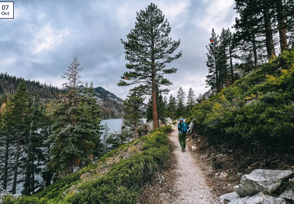
I’m standing at the summit of Mount Tallac at 9,735 feet, gasping for breath after the brutal 3,300-foot climb while simultaneously trying to absorb the 360-degree panorama spread below—Lake Tahoe’s impossible blue stretching north to south, Desolation Wilderness’s granite peaks marching west toward the horizon, Fallen Leaf Lake and Cascade Lake glittering like sapphires in the afternoon sun. After twenty-one visits to Lake Tahoe over thirteen years hiking everything from gentle lakeside strolls to lung-burning summit pushes, I’ve discovered that Tahoe’s 200+ miles of trails offer something increasingly rare in popular mountain destinations—genuine variety without requiring expert skills, spectacular scenery accessible to average hikers, and enough trail options that you could visit ten times and never repeat the same hike twice.
The typical Lake Tahoe hiking experience involves driving to Emerald Bay, descending the Vikingsholm Trail amid crowds of tourists, snapping photos at the castle, then struggling back up that 400-foot elevation gain wondering why the “easy” hike feels so hard. That’s fine for a quick introduction, but it means missing the soul of Tahoe hiking—the alpine lake basins of Desolation Wilderness accessible through moderate day hikes, the coastline granite cliffs of the Rubicon Trail where you’re hiking above that blue water for miles, the wildflower-filled meadows of Mount Rose where July transforms subalpine zones into natural gardens, and the surprisingly accessible summit peaks offering those cover-photo panoramas without requiring technical mountaineering skills. Whether you’re planning your first Tahoe hiking trip and trying to match trails to your fitness level, returning for your fifth visit seeking new challenges, or simply trying to understand which “easy” trails are genuinely easy versus secretly moderate, this comprehensive guide reveals which Lake Tahoe hiking trails deliver on their promises, how to actually secure Desolation Wilderness permits when everyone else fails, and the crowd-avoidance strategies that separate magical morning solitude from frustrating afternoon bottlenecks.
Quick Reference: Best Lake Tahoe Hiking Trails by Difficulty
| Trail Name | Distance | Difficulty | Time | Elevation Gain | Best For | Permits Needed |
|---|---|---|---|---|---|---|
| Fallen Leaf Lake Loop | 2 miles | Easy | 1 hour | Minimal | Families, beginners | No |
| Vikingsholm Trail | 2 miles RT | Easy (down)/Moderate (up) | 1.5-2 hours | 400 ft | History, Emerald Bay views | No |
| Eagle Falls/Eagle Lake | 2 miles RT | Moderate | 1.5-2 hours | 400 ft | Waterfalls, alpine lake | Day permit (Desolation) |
| Rubicon Trail | 9 miles RT | Moderate | 4-5 hours | 200 ft rolling | Coastal hiking, lake views | No |
| Cascade Falls | 2 miles RT | Moderate | 1-1.5 hours | 200 ft | Waterfall, granite scenery | No |
| Maggie’s Peaks | 5 miles RT | Moderate-Hard | 3-3.5 hours | 1,000 ft | Panoramic views, solitude | Day permit (Desolation) |
| Mount Tallac | 9.5 miles RT | Hard | 6-8 hours | 3,300 ft | Summit views, challenge | No |
| Mount Rose | 10 miles RT | Hard | 5-7 hours | 2,100 ft | Highest peak, wildflowers | No |
| Tahoe Rim Trail Sections | 4-20 miles | Varies | 2-10 hours | Varies | Ridge walking, thru-hiking | No (some sections) |
| Floating Island/Cathedral | 8 miles RT | Moderate-Hard | 4-5 hours | 1,000 ft | Alpine lakes, Desolation | Day permit (Desolation) |
Peak Hiking Season: July-September (all trails snow-free, wildflowers, warm weather)
Shoulder Season: June, October (fewer crowds, cooler temps, some snow possible)
Winter Access: December-April (snowshoes required most trails)
Permit Info: Desolation Wilderness requires day permits (free, self-issue at trailheads)
Drive Time from Bay Area: 3.5-4.5 hours | From Sacramento: 2-2.5 hours
Understanding Lake Tahoe’s Trail System (What Nobody Explains Properly)
Before diving into specific trails, let me clarify the geography and management structure that confuses countless first-time Tahoe hikers. Lake Tahoe sits at 6,225 feet elevation in a basin surrounded by peaks reaching 9,000-10,776 feet. This creates three distinct hiking zones: valley floor trails following the shoreline (6,200-6,500 feet), mid-elevation trails climbing into forests and viewpoints (6,500-8,000 feet), and high-elevation trails accessing ridge lines and summits (8,000-10,776 feet).
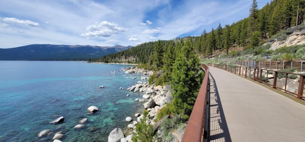
The trail system spans multiple jurisdictions. California State Parks manages the famous Emerald Bay area including Vikingsholm Trail and the Rubicon Trail’s most scenic sections. The U.S. Forest Service (Lake Tahoe Basin Management Unit) oversees most trailheads and forest trails. Desolation Wilderness, managed jointly by Eldorado National Forest and Lake Tahoe Basin Management Unit, contains the area’s most stunning alpine lakes and requires permits even for day hiking. Nevada State Parks controls the east shore including Sand Harbor and Spooner Lake trails. The 165-mile Tahoe Rim Trail circles the entire basin, maintained by the nonprofit Tahoe Rim Trail Association.
This jurisdictional patchwork matters because permit requirements vary. Desolation Wilderness requires permits for all entry—day hikers grab free self-issue permits at trailheads from green permit boxes, overnight backpackers reserve paid permits six months ahead through Recreation.gov. Most other Lake Tahoe trails require no permits, though some trailheads charge parking fees ($10-15).
The elevation consideration affects timing dramatically. Snow closes high-elevation trails (above 8,500 feet) from November through June in typical years, with trails becoming accessible in this order: valley floor (May), mid-elevation (June), high-elevation (July). I’ve hiked Mount Tallac during early July and encountered 3-foot snowdrifts on the upper slopes, while the same trail in late July showed no snow whatsoever. Check current conditions before committing to high-elevation hikes during June and early July.
Afternoon thunderstorms occur frequently July-September, typically building over peaks between 2-4 PM. I’ve been caught above treeline during several afternoon storms, and the combination of lightning, hail, and sudden temperature drops creates genuine danger. Start early (before 7 AM) for summit hikes to reach high points by noon and descend before storms develop.
Easy Trails: Perfect for Families & Beginners
Fallen Leaf Lake Loop
Distance: 2 miles | Time: 1 hour | Elevation: Minimal | Difficulty: Easy
This gentle lakeside loop delivers exactly what families with young kids need—flat walking on well-maintained paths, constant lake views, and the flexibility to turn around anywhere if someone gets tired. Fallen Leaf Lake sits about three miles southwest of South Lake Tahoe, overshadowed by towering Mount Tallac rising dramatically to the west. The 2-mile loop circles the north end of the lake through mixed pine and fir forest, with frequent openings offering those postcard views of blue water backed by granite peaks.
I’ve hiked this trail with everyone from my 70-year-old parents to friends’ preschoolers, and it accommodates all fitness levels perfectly. The path stays flat and wide enough for side-by-side walking, with minimal roots or rocks to trip over. Multiple spur trails branch down to small beaches perfect for rock-skipping, picnicking, or wading in the shallows (water stays cold even in August, typically 60-65°F).
Start from the marina area or Fallen Leaf Campground, where parking fills by 9-10 AM on summer weekends but usually has space on weekdays. The trail technically continues around the entire lake (about 5.5 miles total), but most families stick to the developed north end loop before the trail becomes rougher and less maintained.
What makes it special: This trail provides mountain lake beauty without the suffering. No steep climbs, no technical sections, just pleasant walking through beautiful scenery. It’s the perfect introduction to Lake Tahoe hiking for anyone nervous about elevation or fitness requirements.
Timing strategy: Visit early morning (before 9 AM) for parking ease and wildlife viewing—I’ve seen deer, waterfowl, and occasionally black bears on dawn walks. Afternoon visits work fine but mean fighting for parking and sharing the trail with more people.
Vikingsholm Trail to Emerald Bay
Distance: 2 miles round-trip | Time: 1.5-2 hours | Elevation: 400 feet down/up | Difficulty: Easy down, Moderate up
This is Lake Tahoe’s most-hiked trail, and for good reason—the descent provides jaw-dropping Emerald Bay views while leading to Vikingsholm Castle, one of North America’s finest examples of Scandinavian architecture. But here’s what guidebooks don’t emphasize: the “easy” rating applies only to the descent. The return climb gains 400 feet in less than a mile via consistent uphill that leaves unprepared visitors gasping and resting every 100 yards.
The trail starts at the Emerald Bay overlook parking area on Highway 89, typically filling by 9-10 AM summer weekends (arrive early or walk from roadside pullouts). The paved path switchbacks steadily downward through mixed forest, with periodic viewpoints revealing Emerald Bay’s impossible turquoise waters, Fannette Island’s tiny tea house, and those surrounding granite peaks creating one of California’s most photographed scenes.
Vikingsholm Castle sits at trail’s end on Emerald Bay’s shore, open for paid tours ($10, late May-September) showcasing wealthy eccentric Lora Josephine Knight’s obsession with Scandinavian design. The hand-carved details, sod roof (now replaced), and waterfront location make the tour worthwhile, though you can explore the grounds and small beach without paying for interior access.
After three visits here across different seasons, I’ve learned the return climb strategy: start slow, take water breaks every 5-7 minutes regardless of whether you feel you need them, and don’t compare your pace to descending hikers passing by. The climb takes most people 25-40 minutes depending on fitness and how many rest stops they require.
Hidden bonus: Continue past Vikingsholm onto the Rubicon Trail heading north toward D.L. Bliss. Even just 10-15 minutes of additional hiking provides spectacular coastal views and significantly fewer crowds than the main Vikingsholm area.
What surprised me: The return climb challenges many more people than expect based on the “easy” trail rating. I’ve watched hundreds struggle uphill, clearly unprepared for sustained climbing. If you have knee problems or cardiovascular limitations, seriously consider whether this return climb suits you.
Upper Eagle Falls
Distance: 0.5 miles round-trip | Time: 15-20 minutes | Elevation: 100 feet | Difficulty: Easy
For the shortest route to a spectacular waterfall, Upper Eagle Falls delivers maximum reward for minimal effort. Located directly across Highway 89 from Emerald Bay State Park, the trail climbs a series of stone-carved stairs through granite formations to a wooden bridge overlooking the multi-tiered falls cascading dramatically over polished granite.
Parking fills quickly (by 9 AM summer weekends) at the small Eagle Falls trailhead, but roadside pullouts within short walking distance provide overflow options. The stone stairs mean this trail doesn’t accommodate strollers or wheelchairs, and some visitors find the uneven steps challenging, but the distance is short enough that most people manage fine.
The falls themselves peak during spring and early summer (May-July) when snowmelt creates dramatic flow. By late summer (August-September), water volume drops significantly—still worth visiting for the granite scenery, but don’t expect roaring cascades. I photographed Eagle Falls during peak flow in June 2023, and the volume created genuine mist clouds requiring waterproof camera protection.
Continue to Eagle Lake: Most guidebooks treat this as a separate hike, but it’s really just an extension of Upper Eagle Falls trail. From the falls bridge, continue uphill on progressively steeper terrain (lots more stone stairs) for another 0.75 miles and 300 additional feet of elevation gain to reach Eagle Lake—a stunning alpine lake nestled in granite basins that makes the extra effort worthwhile. The combined Eagle Falls + Eagle Lake hike totals 2 miles round-trip, gains 400 feet elevation, and qualifies as moderate difficulty.
Moderate Trails: The Sweet Spot for Most Hikers
Rubicon Trail
Distance: 9 miles round-trip (or 4.5 miles one-way with shuttle) | Time: 4-5 hours RT | Elevation: 200 feet rolling | Difficulty: Moderate
The Rubicon Trail ranks as Lake Tahoe’s premier coastal hike, hugging shoreline granite cliffs high above the water while providing constantly changing perspectives on that impossible blue stretching to distant peaks. After hiking this trail six times spanning different seasons and times of day, I maintain that Rubicon delivers Lake Tahoe’s best combination of scenery, accessibility, and genuine wilderness atmosphere despite its proximity to developed areas.
The trail runs 4.5 miles one-way between D.L. Bliss State Park (north) and Emerald Bay’s Vikingsholm (south). Most hikers approach it as an out-and-back from either end rather than arranging car shuttles between trailheads. Starting from D.L. Bliss provides the advantage of getting the modest uphill sections done early while you’re fresh, then enjoying relatively flat or downhill terrain for much of the route toward Emerald Bay.
The trail wastes no time delivering views—within the first mile from D.L. Bliss, you’re walking along granite cliffs 50-100 feet above the water with panoramic lake vistas interrupted only by occasional Jeffrey pines framing the scenes. Lighthouse Point (about 1 mile from D.L. Bliss) offers a perfect turnaround point for families or anyone wanting Rubicon experience without committing to the full distance.
Rubicon Point (1.7 miles from D.L. Bliss) features dramatic cliffs where experienced cliff jumpers leap 30-40 feet into deep water during summer. I’ve watched this spectacle dozens of times but attempted it only once—the cold shock hitting 60-degree water takes your breath away, and the rock’s height looks significantly more intimidating from the edge. Don’t attempt this unless you’re an experienced cliff jumper; injuries occur regularly.
The trail continues past Rubicon Point through varied terrain—sometimes right at water level where small beaches provide swimming access, other times climbing 100+ feet above the lake for elevated perspectives. About 3 miles from D.L. Bliss, you’ll pass through Emerald Bay campground before reaching Vikingsholm at trail’s end.
What makes it special: Unlike most Lake Tahoe hiking that heads inland into forests, Rubicon keeps that blue water constantly in view. You’re perpetually hiking above or beside the lake, with perspectives changing every few hundred yards as the trail rounds points, crosses coves, and navigates granite formations.
Crowd management: The trail gets busy near both trailheads but thins significantly in the middle sections. During my weekday September hikes, I’ve encountered maybe twenty people total over 4-5 hours—busy but not crowded. Summer weekend crowds increase but nothing approaching Yosemite or other California hiking hotspots.
Swimming opportunities: Multiple small beaches and coves along the trail provide swimming access. The water stays cold (55-65°F even in summer) but refreshing on hot days. Rubicon Point offers the most dramatic (and dangerous) entry, while gentler beaches near Lighthouse Point work better for families.
Cascade Falls
Distance: 2 miles round-trip | Time: 1-1.5 hours | Elevation: 200 feet | Difficulty: Moderate
Cascade Falls provides one of Tahoe’s most accessible waterfall hikes, delivering spectacular cascades tumbling over granite slabs with minimal time and effort investment. Located on the west shore at Bayview Campground (about 7 miles north of South Lake Tahoe on Highway 89), the trail climbs steadily but never brutally through mixed conifer forest before emerging at the falls’ base.
The 200-foot elevation gain occurs gradually over one mile, making this genuinely moderate rather than the secretly-hard-but-rated-moderate trails that plague some guidebooks. I’ve hiked Cascade Falls with friends ranging from casual walkers to serious athletes, and everyone finds it manageable with occasional water breaks.
The falls themselves showcase classic Sierra Nevada granite-and-water beauty—Cascade Creek tumbles down smooth granite slabs in multiple tiers, creating those photogenic white-water ribbons against gray rock that define Tahoe waterfall aesthetics. Peak flow occurs May-July during snowmelt, when the falls roar impressively and create mist clouds at the base. By August-September, flow diminishes significantly but remains worth visiting for the granite scenery and cooler forest atmosphere.
Insider tip: Continue past Cascade Falls for another 0.5 miles and 300 feet of elevation gain to reach Granite Lake (also called Bayview Lake), a small alpine lake tucked in granite basin below Maggie’s Peaks. This extension creates a 3-mile round-trip hike gaining 500 feet total, still moderate difficulty but delivering bonus alpine lake scenery most Cascade Falls visitors miss entirely.
Best timing: Visit in late spring or early summer (late May through June) for maximum water flow. The trail faces south, meaning afternoon sun makes it hot during July-August—morning hikes provide cooler temperatures and better photography lighting.
Maggie’s Peaks
Distance: 5 miles round-trip | Time: 3-3.5 hours | Elevation: 1,000 feet | Difficulty: Moderate to Hard
Maggie’s Peaks delivers exceptional panoramic views for moderate effort, making it my go-to recommendation for intermediate hikers ready to step beyond easy coastal trails into more challenging terrain. The trail starts at Bayview Campground (same trailhead as Cascade Falls) but heads right instead of left, climbing through Desolation Wilderness toward two granite peaks offering 360-degree views encompassing Lake Tahoe, Emerald Bay, Fallen Leaf Lake, Cascade Lake, and the Desolation Wilderness backcountry.
The first mile follows the same path to Granite Lake/Bayview Lake mentioned in the Cascade Falls description, gaining 500 feet to reach the small alpine lake sitting in a granite bowl. From here, the trail steepens significantly, climbing via switchbacks up the rocky slope toward Maggie’s Peaks. The final 0.5 miles before the summit involves some easy rock scrambling—nothing requiring technical skills, but you’ll occasionally use hands for balance on steeper granite sections.
The payoff justifies the effort. Standing atop Maggie’s Peaks (approximately 8,699 feet elevation), you’re surrounded by Sierra Nevada grandeur. Lake Tahoe stretches north and east, Emerald Bay sits directly below, Desolation Wilderness’s granite peaks march west, and on clear days you can identify landmarks 30+ miles away. During my September 2024 summit, perfect visibility revealed details across the entire lake basin, creating those “top of the world” feelings that make summit hikes worthwhile.
Desolation Wilderness permit: This trail enters Desolation Wilderness, requiring a free day-use permit available at the Bayview trailhead from green self-issue permit boxes. Fill out the simple form, sign it, tear off the bottom portion and deposit it in the box, then carry the permit with you. Violation of this requirement results in citations (rangers do patrol and check permits).
What surprised me: The crowds (or lack thereof). Despite starting from a popular trailhead and offering spectacular views, Maggie’s Peaks sees dramatically fewer hikers than coastal trails. During summer Saturday hikes, I’ve encountered maybe 15-20 people total, and weekday visits often mean summit solitude.
Challenging Trails: Summit Peaks & Long-Distance Routes
Mount Tallac
Distance: 9.5 miles round-trip | Time: 6-8 hours | Elevation: 3,300 feet | Difficulty: Hard
Mount Tallac stands as Lake Tahoe’s signature summit hike—a brutal 3,300-foot climb rewarded by unmatched 360-degree panoramas encompassing the entire lake basin, Desolation Wilderness, and seemingly half of California and Nevada. After four summit attempts over eight years (successfully summiting three times, turning back once due to afternoon thunderstorms), I can confirm both that this hike fully deserves its “hard” rating and that the views from Tallac’s 9,735-foot summit rank among the best I’ve experienced anywhere.
The trail starts at the Mount Tallac trailhead on Mount Tallac Road (turn off Highway 89 between Camp Richardson and Emerald Bay). The first 2 miles climb gradually through forest alongside a creek, providing gentle warm-up before the real climbing begins. At approximately 2 miles, you’ll reach Floating Island Lake—a beautiful alpine lake that makes an excellent turnaround point for anyone realizing they’re not up for the full summit push.
Past Floating Island Lake, the trail steepens considerably, climbing via long switchbacks through increasingly sparse forest as you approach treeline around 8,500 feet. The terrain transitions from forest to subalpine scrub to bare granite and scree on the upper slopes. The final mile to the summit involves sustained steep climbing with minimal shade—this section always feels longer and harder than the distance suggests.
Summit views deliver everything you’ve suffered for. Lake Tahoe spreads below you in that impossible sapphire blue, Fallen Leaf Lake and Cascade Lake glitter to the south, Desolation Wilderness’s granite peaks extend west, and on clear days you can see into Nevada’s high desert country to the east. I’ve spent 30-45 minutes on the summit during each successful climb, and I still have trouble pulling myself away to begin the descent.
Critical considerations: Start early—I recommend 6-7 AM starts for mid-summer climbs, even earlier for July/August when afternoon thunderstorms develop regularly. Bring 3-4 liters of water per person (more in hot weather), substantial snacks or lunch, sun protection (zero shade above treeline), and layers for the summit where temperatures run 15-20 degrees cooler than the trailhead. The elevation gain and distance mean most hikers need 6-8 hours including breaks, and you want to summit by noon to avoid afternoon storms.
Realistic difficulty assessment: This hike challenges many more people than expect based on reading trail descriptions. The combination of distance, elevation gain, and sustained steep sections on the upper mountain means you need genuine fitness and hiking experience. I’ve watched dozens of people turn back below the summit, clearly unprepared for the difficulty. Don’t attempt this as your first Lake Tahoe hike unless you’re quite fit and experienced with sustained mountain climbing.
Mount Rose
Distance: 10 miles round-trip | Time: 5-7 hours | Elevation: 2,100 feet | Difficulty: Hard
Mount Rose (10,776 feet) reigns as the Tahoe Basin’s third-highest peak and the highest summit accessible via maintained trail. Located on the north shore above Incline Village via Mount Rose Highway (Highway 431), this trail combines sustained climbing with spectacular wildflower displays (July) and that unique combination of lake views and high-desert vistas toward Reno and Nevada’s basin-and-range country.
The trailhead sits at approximately 8,800 feet at the Mount Rose Highway summit, meaning you start well above treeline with immediate expansive views. The trail climbs steadily through subalpine meadows for the first 2 miles—during July, these meadows explode with wildflowers creating natural gardens of lupine, paintbrush, mule’s ears, and dozens of other species. I hiked Mount Rose during peak wildflower season in July 2023, and the color displays rivaled anything I’ve seen in the Sierra Nevada.
After the initial meadow section, the trail steepens and enters a long stretch of exposed ridgeline walking with constant views but zero shade. The final 2 miles to the summit involve sustained climbing on rocky trail through increasingly barren terrain as vegetation thins with elevation. The summit itself features a large granite platform offering 360-degree views—Lake Tahoe to the south, Reno sprawling below to the northeast, and endless Nevada desert extending east to distant mountain ranges.
What makes it worthwhile: Mount Rose provides a completely different perspective than south shore summits. You’re looking down at Lake Tahoe from the north, seeing the entire lake stretching toward Emerald Bay 25 miles away. The high desert views toward Nevada add variety absent from purely Sierra Nevada viewpoints. And unlike Mount Tallac’s brutal elevation gain over shorter distance, Mount Rose spreads its 2,100-foot climb over 5 miles, creating more sustainable grade for many hikers.
Elevation considerations: Starting at 8,800 feet means you’re immediately dealing with thin air, and the summit at 10,776 feet can cause altitude symptoms in some people—headaches, nausea, shortness of breath. Give yourself extra time, move slowly, and don’t push through altitude sickness symptoms. I experienced mild altitude headache during my summit and needed extra rest breaks on the descent.
Wildflower timing: Peak wildflowers occur mid-July through early August most years, though the exact window shifts based on winter snowpack and spring temperatures. Earlier July visits risk encountering snow on upper slopes; later August visits show fading flowers. Check current conditions before committing to specific dates for flower-focused hikes.
Tahoe Rim Trail: The 165-Mile Circuit
Distance: 165 miles total, sections 4-20 miles | Time: 10-15 days complete, 2-10 hours sections | Elevation: Varies by section | Difficulty: Varies (mostly moderate to hard)
The Tahoe Rim Trail circles the entire Lake Tahoe Basin for 165 miles, traversing high ridges and mountain passes with constantly changing perspectives on the lake below. While most hikers never attempt the full circuit (requiring 10-15 days of backpacking with serious logistics), countless day-hiking sections offer everything from family-friendly 4-mile out-and-backs to challenging 15-mile point-to-point traverses.
After hiking seven different TRT sections over the years, I appreciate how the trail provides access to terrain and views impossible from valley floor trails. Rather than looking across at mountains, you’re walking along mountain crests looking down at Lake Tahoe from above—a perspective shift that transforms the lake-gazing experience completely.
Popular Day-Hiking TRT Sections:
Tahoe Meadows to Relay Peak (7 miles round-trip): North shore section featuring wildflower meadows and ridge walking with excellent lake views. Moderate difficulty, 3-4 hours, best July-September. Perfect for families seeking genuine mountain hiking without technical challenges. I hiked this during July 2024, and the wildflower displays across Tahoe Meadows rivaled Mount Rose’s famous blooms.
Brockway Summit to Tahoe City (9.6 miles one-way): North shore section combining forest and ridge walking with periodic lake views. Moderate difficulty with some steep sections. Requires shuttle between trailheads or doubling distance for out-and-back. Spectacular fall colors in late September when aspens turn golden.
Mount Rose Trail (already covered above): The Mount Rose summit trail follows TRT for much of its route, showcasing how TRT incorporates existing trails rather than creating entirely new paths.
Echo Lakes to Desolation Wilderness (10+ miles): South shore section providing access to Desolation Wilderness alpine lake basins. Moderate to hard difficulty depending on exact route chosen. Requires overnight wilderness permits for camping, but day hiking is permitted with standard Desolation day permits.
The complete TRT requires no permits for most sections, though overnight camping in Desolation Wilderness requires advance permits through Recreation.gov. The trail maintains consistently good quality thanks to volunteer maintenance by the Tahoe Rim Trail Association, with clear signage and regular maintenance keeping it accessible to hikers with basic navigation skills.
Thru-hiking considerations: Completing the full 165-mile circuit appeals to adventure-minded backpackers, typically taking 10-15 days depending on pace and chosen daily mileage. Water sources exist but aren’t always reliable (especially in late summer), resupply options are limited without departing the trail, and elevation changes add up to over 20,000 feet of cumulative climbing. I’ve seriously considered attempting a thru-hike multiple times but keep deciding that focusing on favorite sections suits my hiking style better than forcing the complete circuit.
Desolation Wilderness: Permit System Explained
Desolation Wilderness contains Lake Tahoe’s most stunning alpine lake scenery—granite basins filled with crystalline water, peaked by mountains reaching 9,000-10,000 feet, and crossed by trails accessing dozens of lakes within day-hiking distance. But the beauty creates heavy use, necessitating permit requirements that confuse first-time visitors.
Day hiking permits (free): Required for all Desolation Wilderness entry, available at trailheads from green self-issue permit boxes. Fill out the simple form asking for your name, group size, entry date, and planned route. Sign the form, tear off the bottom portion and deposit it in the permit box, carry the top portion with you. Forest Service rangers patrol and check permits—violations result in citations. The permit process takes 2-3 minutes and prevents zero hiking; just do it.
Overnight permits (paid): Required for backpacking camping in Desolation Wilderness, subject to quotas during peak season (Friday before Memorial Day through September 30). These permits cost $5-10 per person depending on trip length, plus $6 reservation fee, available six months in advance through Recreation.gov. Popular zones sell out quickly—Echo Lakes, Twin Lakes, and Rockbound zones fill within minutes of availability opening. Alternative zones and weekday dates show better availability.
Bear canisters: Required for all overnight Desolation visits, mandatory as of 2024 for the entire Tahoe Rim Trail system. These hard-sided containers protect food from bears and must meet specific approval standards (check Forest Service website for approved models). Rental options exist at outdoor shops around Lake Tahoe ($5-10 per day).
Trail-specific permit notes: Popular day hikes entering Desolation Wilderness include Eagle Lake (from Eagle Falls trailhead), Gilmore Lake and other lakes from Glen Alpine trailhead, and various routes from Bayview/Cascade Falls trailhead. All require day permits grabbed at trailheads—plan an extra 3-5 minutes for the self-issue process.
Seasonal Guide: Best Times for Different Trails
Summer (July-August):
- All trails accessible and snow-free
- Warmest weather (75-85°F days, 45-55°F nights)
- Maximum crowds on popular trails
- Afternoon thunderstorms common
- Peak wildflowers early-mid July
- Best for: Summit hikes, alpine lake explorations, families with school-age kids
Late Spring/Early Summer (May-June):
- Lower elevation trails accessible, high peaks still snowy
- Waterfalls at peak flow from snowmelt
- Moderate temperatures (65-75°F days, 40-50°F nights)
- Fewer crowds than peak summer
- Mosquitoes peak in June near water
- Best for: Waterfall hikes (Cascade, Eagle Falls), coastal trails (Rubicon), moderate elevation gains
Fall (September-October):
- Decreasing crowds after Labor Day
- Beautiful weather (70-80°F days in September, 60-70°F in October)
- Golden aspen colors at higher elevations
- Water flow diminishes in waterfalls
- Some trails close mid-October
- Best for: Summit hikes with solitude, fall colors, comfortable hiking temperatures
Winter (November-April):
- Most trails inaccessible or requiring snowshoes
- Snow covers trails above 7,000 feet
- Cold temperatures (30-45°F days, 15-30°F nights)
- Extreme solitude
- Specialized winter skills required
- Best for: Snowshoeing, winter mountaineering, experienced backcountry travelers
Budget Breakdown: What Lake Tahoe Hiking Actually Costs
Let me provide realistic cost estimates because most guides ignore expenses beyond gas.
Day Hiking from Bay Area (Solo):
- Gas round-trip: $70-90
- Trailhead parking (if required): $10-15
- Lunch/snacks: $15-20
- Desolation permit: Free
- Emergency supplies already owned: $0
- Total: $95-125 for full day
Weekend Camping & Hiking Trip (2 adults):
- Gas: $70-90
- Camping (2 nights): $70-90
- Groceries: $60-80
- Trailhead parking: $15-20
- Forgotten supplies at camp store: $20-30
- Total: $235-310
Gear Investment for Serious Hiking:
- Quality hiking boots: $120-200
- Day pack: $60-100
- Trekking poles: $50-120
- Water reservoir/bottles: $30-50
- Navigation (GPS/maps): $30-80
- First aid kit: $30-50
- One-time total: $320-600 (lasts multiple years)
Frequently Asked Questions
Do I need hiking boots for Lake Tahoe trails?
For easy trails like Fallen Leaf Lake or Vikingsholm, quality athletic shoes work fine. Moderate and hard trails benefit significantly from hiking boots or trail runners with aggressive tread—I’ve hiked Mount Tallac in both trail runners and boots, and the ankle support and traction matter enormously on steep, rocky sections. The 6,200+ foot elevation means trails often feature loose granite, exposed roots, and rocky terrain that challenges smooth-soled casual shoes. Invest in proper footwear if planning multiple hikes or tackling anything beyond easy valley trails.
Are Lake Tahoe hiking trails crowded?
Popular trails like Vikingsholm, Rubicon Trail’s endpoints, and Eagle Falls get genuinely busy during summer weekends—expect dozens to hundreds of other hikers. But crowd levels drop dramatically on weekdays, shoulder seasons (May-June, September-October), and trails beyond the famous highlights. Summit hikes like Mount Tallac and Mount Rose see moderate traffic even on weekends. I’ve hiked Maggie’s Peaks on Saturday mornings and encountered fewer than twenty people total. Strategic timing (early starts, weekday visits) and choosing slightly less-famous trails make huge differences in crowd levels.
Can I hike Lake Tahoe trails in June?
Yes, with important caveats. Lower elevation trails (under 7,500 feet) including Rubicon Trail, Vikingsholm, Cascade Falls, and Fallen Leaf Lake become accessible in June, often by early May. Higher elevation trails above 8,000 feet frequently retain significant snow through June—Mount Tallac, Mount Rose, and many Desolation Wilderness routes may be impassable or require snowshoes and winter navigation skills through mid-to-late June. Check current conditions through Tahoe area ranger stations or recent trip reports before committing to high-elevation June hikes. I’ve turned back from June summit attempts three times due to unsafe snow conditions.
Do I need a permit to hike at Lake Tahoe?
Most Lake Tahoe trails require no permits. The major exception: Desolation Wilderness requires free day-use permits for all entry, available at trailheads through self-issue permit boxes. The process takes 2-3 minutes—fill out basic information, sign the form, deposit the bottom portion in the box, carry the permit with you. Overnight backpacking in Desolation Wilderness requires paid permits ($5-10 per person) reserved through Recreation.gov. Some trailheads charge parking fees ($10-15) but don’t confuse parking fees with permits—they’re separate requirements.
What’s the best hiking trail for first-time Lake Tahoe visitors?
The Rubicon Trail delivers Lake Tahoe’s signature hiking experience—constant lake views, dramatic granite cliffs, varied terrain, and genuine wilderness atmosphere without requiring exceptional fitness. Start from D.L. Bliss and hike 2-3 miles toward Emerald Bay, then turn around when you’ve had enough. This approach provides spectacular coastal hiking with the flexibility to adjust distance based on your energy, time, and interest level. Alternative: Eagle Falls to Eagle Lake (2 miles round-trip, moderate) combines waterfall, alpine lake, and manageable distance for families or moderate-fitness visitors.
Are there bears on Lake Tahoe hiking trails?
Yes, black bears are common throughout the Lake Tahoe Basin, though trail encounters remain relatively rare compared to campground incidents. I’ve seen bears on trails four times in thirteen years of Tahoe hiking—each time the bear noticed me, made brief eye contact, and immediately left the area. Black bears are not aggressive toward humans but are naturally curious and food-motivated. Make noise while hiking (talking, occasional shouts on blind corners), never approach bears for photos, and if you encounter a bear, make yourself appear large, make noise, and back away slowly. Never run. Carry bear spray if it makes you feel safer, though most experienced Tahoe hikers don’t bother for day hiking.
Can I bring my dog on Lake Tahoe hiking trails?
Dog policies vary by managing agency. California State Parks (D.L. Bliss, Emerald Bay, Sugar Pine Point) prohibit dogs on trails. U.S. Forest Service trails generally allow leashed dogs, including most Desolation Wilderness trails. Nevada State Parks permit leashed dogs. Check specific trail regulations before bringing your dog—violations result in citations and frustration when you’re turned away at trailheads. Many hikers successfully bring dogs on Forest Service trails like Mount Tallac, Mount Rose, and Tahoe Rim Trail sections, though you’re responsible for waste removal and keeping dogs leashed around other hikers.
What time should I start hiking at Lake Tahoe?
For summit hikes and anything over 8,000 feet elevation, start by 6-7 AM to reach high points by noon and descend before afternoon thunderstorms develop (typically 2-4 PM July-September). Earlier starts also mean cooler temperatures, smaller crowds, better wildlife viewing, and less competition for trailhead parking. For shorter, lower-elevation trails, morning starts between 7-9 AM work well. Afternoon starts risk afternoon storms, intense sun exposure, and full parking lots. I’ve shifted to almost exclusively early starts after getting caught in too many afternoon thunderstorms and fighting for parking during mid-morning arrivals.
How fit do you need to be to hike Lake Tahoe?
Fitness requirements vary dramatically by trail choice. Easy trails like Fallen Leaf Lake or Upper Eagle Falls accommodate anyone who walks regularly, including families with young kids and seniors with reasonable mobility. Moderate trails like Rubicon or Cascade Falls require ability to hike 4-5 miles with 200-400 feet of elevation gain—most people with basic fitness handle these fine with rest breaks. Hard trails like Mount Tallac or Mount Rose demand genuine fitness for sustained uphill climbing over 5-9 miles with 2,000-3,000+ feet of elevation gain. Don’t attempt summit hikes as your first Lake Tahoe experience unless you regularly hike challenging terrain at home. The combination of distance, elevation gain, and thin air at altitude challenges many more people than expect.
What should I pack for a Lake Tahoe day hike?
Essential items regardless of trail: 2-3 liters of water per person (more for hot days or long hikes), substantial snacks or lunch, sun protection (SPF 50+ sunscreen, hat, sunglasses), trail map or downloaded offline maps, first aid basics, headlamp or flashlight (in case you’re out longer than planned), and layers including rain jacket. For moderate to hard trails, add: trekking poles, extra layers (fleece, insulated jacket), emergency shelter (space blanket), whistle, and fully charged cell phone (though service is limited). The Sierra Nevada’s weather changes rapidly—I’ve experienced all four seasons in a single June day, requiring constant layer adjustments. Pack more than you think you need.
Key Takeaways: Choosing Your Perfect Lake Tahoe Hiking Experience
After twenty-one visits to Lake Tahoe over thirteen years hiking everything from gentle lakeside strolls to lung-burning summit pushes, I’ve learned that Lake Tahoe’s hiking diversity creates both opportunity and challenge. The opportunity: trails exist for literally every fitness level and interest, from wheelchair-accessible paths to technical mountaineering routes. The challenge: choosing appropriate trails from 200+ options without getting in over your head or settling for disappointingly easy experiences when you’re capable of more.
The Rubicon Trail deserves its reputation as Lake Tahoe’s signature hike, combining constant lake views with moderate difficulty accessible to most hikers. Whether you walk just the first mile to Lighthouse Point or complete the full 9-mile round-trip to Vikingsholm, you’re experiencing coastal hiking that showcases why Lake Tahoe attracts millions annually. I’ve hiked Rubicon six times and never tired of those granite cliffs, blue water perspectives, and wilderness atmosphere despite proximity to developed areas.
Summit hikes deliver different rewards requiring significantly more effort. Mount Tallac’s brutal 3,300-foot climb and Mount Rose’s 2,100-foot ascent separate casual hikers from committed ones, but the 360-degree panoramas from 9,000-10,000+ feet justify every step of suffering. These aren’t everyone’s ideal hikes—plenty of visitors prefer coastal beauty over summit views—but if you’re physically capable and enjoy challenging yourself, Lake Tahoe’s summits provide achievements you’ll remember long after return to sea level.
Desolation Wilderness deserves special emphasis. This protected area contains Lake Tahoe’s most stunning alpine lake scenery, accessed through moderate day hikes like Eagle Lake or Maggie’s Peaks. The free self-issue permit system adds minimal hassle (literally 2-3 minutes at trailheads) while protecting wilderness quality through use tracking. Don’t skip Desolation hikes due to permit confusion—the process is genuinely simple, and the scenery surpasses anything accessible without permits.
Timing strategy separates magical experiences from frustrating ones. Early starts (6-8 AM) provide cooler temperatures, smaller crowds, better parking, wildlife viewing opportunities, and safety margins for afternoon storms. Weekday visits dramatically reduce crowds compared to summer weekends. Shoulder seasons (late May-June, September-October) offer the best weather-to-crowd ratio, though June’s high-elevation snow and October’s limited accessibility windows require flexibility.
The elevation consideration surprises lowland visitors consistently. Lake Tahoe’s 6,225-foot basin elevation means you’re starting hikes at elevations where many California peaks end, and summits reach 9,000-10,776 feet where thin air affects everyone regardless of sea-level fitness. Give yourself extra time, move slower than at home, hydrate obsessively (thin air dehydrates faster), and don’t push through altitude symptoms. I’ve experienced altitude headaches on three separate summit hikes despite regular mountain hiking experience.
Budget realistic time estimates. Trail guidebooks often list “average” hiking times that assume steady movement without stops. Add 30-50% more time for photography stops, rest breaks, lunch, wildlife watching, and simply enjoying scenery rather than rushing past it. A trail listed as “4 hours” typically takes me 5-6 hours when I actually account for all the stopping, gawking, and photographing I do.
The trails that stay with me years later combine spectacular scenery with genuine challenge. The Rubicon Trail’s endless coastal perspectives. Mount Tallac’s summit panoramas after brutal climbing. Maggie’s Peaks’ surprising solitude despite remarkable views. Eagle Lake’s waterfall approach and alpine setting. These experiences required planning, proper equipment, early starts, and willingness to push beyond comfort zones, but they delivered Lake Tahoe hiking moments that justify the drive, the preparation, and the inevitable quad soreness the following day.
Lake Tahoe’s hiking offers something increasingly rare in popular mountain destinations—genuine world-class trail experiences accessible without technical mountaineering skills, advance lottery permits, or expedition-level planning. You need reasonable fitness for summit hikes, yes. You need proper equipment and early starts for safety. But you don’t need crampon skills, rope work knowledge, or expedition experience. Lake Tahoe hiking rewards those who prepare appropriately, choose trails matching their abilities, and remember that sometimes the crowds, the steep climbs, and the afternoon thunderstorm risks are simply the price of admission to alpine beauty that photographs struggle to capture accurately. Pay that price willingly, plan strategically, and Lake Tahoe’s trails reward you with memories and Instagram posts that last far longer than the drive home.
