
I’m standing at Pfeiffer Beach watching waves crash through the keyhole rock arch, and a couple from Texas asks me if Big Sur is really worth the hype. After visiting this dramatic stretch of California coastline seventeen times over the past decade—from my disastrous first trip when I arrived completely unprepared to becoming the person friends text for Big Sur planning advice—I can tell you the answer is yes, but only if you understand what you’re getting into.
Big Sur isn’t a town. It’s a 90-mile stretch of Highway 1 clinging to cliffs between Carmel and San Simeon, where the Santa Lucia Mountains crash dramatically into the Pacific Ocean. There are no stoplights, no chain hotels, no grocery stores, and exactly one gas station (charging $7+ per gallon). Most travel guides either romanticize Big Sur without mentioning the challenges or focus so heavily on logistics that they miss what makes this place magical. This complete Big Sur travel guide provides everything I wish I’d known before my first visit: realistic expectations about costs and crowds, specific hiking recommendations with honest difficulty assessments, practical advice about where to actually sleep and eat, seasonal timing that matters more here than almost anywhere else, and the real story about what makes Big Sur worth planning your entire California road trip around.
What Exactly Is Big Sur? Understanding California’s Most Dramatic Coast
Big Sur defies easy categorization, which explains why first-time visitors often arrive with wildly incorrect expectations. This isn’t a beach resort town where you’ll find boardwalks and souvenir shops. It’s not a city with restaurants on every corner. Big Sur is a sparsely populated, ruggedly beautiful region where nature dominates and human infrastructure exists on nature’s terms.
The name “Big Sur” comes from “el sur grande” (the big south), referring to the vast wilderness south of the Carmel mission. Today it describes the roughly 90-mile stretch of Highway 1 from Carmel Highlands down to Ragged Point, encompassing numerous state parks, private land, and some of California’s most spectacular coastal scenery. Only about 1,800 people live in Big Sur year-round, spread across this entire stretch in isolated pockets rather than concentrated in any single town.
When people say they’re “going to Big Sur,” they usually mean driving Highway 1 through the region, stopping at iconic viewpoints and maybe hiking a trail or two. Some visitors base themselves in the area for multiple days, treating Big Sur as a destination rather than a drive-through. Both approaches work, but they require different planning strategies and deliver different experiences.
The landscape that makes Big Sur famous—those dramatic cliffs, crashing waves, and fog-shrouded redwoods—also creates significant practical challenges. Highway 1 frequently closes due to landslides and storm damage, sometimes for months at a time. Services are limited and expensive. Cell service is spotty to nonexistent in many areas. Weather can change dramatically within minutes, transforming sunny coastal views into fog-obscured nothingness.
Understanding these realities before you arrive transforms Big Sur from a potentially frustrating experience into the adventure of a lifetime. I learned this the hard way on my first visit when I showed up on a busy summer Saturday with no reservations, $20 in my wallet, and a quarter tank of gas. That experience taught me more about Big Sur planning than any guidebook could, though I wouldn’t recommend replicating it.
When to Visit Big Sur: Seasonal Realities Beyond the Instagram Photos
Big Sur’s dramatic beauty looks amazing in photos year-round, but the on-the-ground reality varies enormously by season. After visiting in every month except January, I’ve learned that timing your Big Sur trip can mean the difference between magical memories and expensive disappointment.
Spring (March-May): Green Hills and Wildflowers
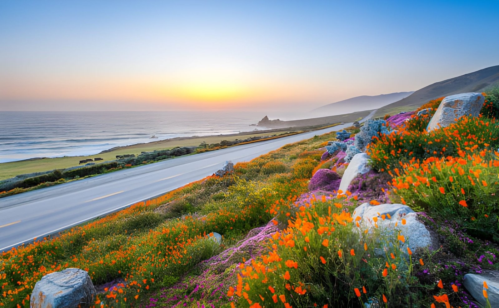
Spring might be my favorite Big Sur season, though it comes with weather unpredictability that keeps some visitors away. The hills turn vibrant green after winter rains, creating a landscape dramatically different from summer’s brown grasslands. Wildflowers bloom throughout the region, particularly in April and early May. McWay Falls flows strongest during this period, and waterfalls that remain dry most of the year cascade down cliffsides after spring storms.
The weather during spring oscillates between gorgeous sunny days and rainy storms that can close Highway 1. March tends toward wet and unstable, April offers better conditions but still brings occasional rain, and May typically delivers more consistent weather as California’s dry season approaches. Temperatures range from the mid-50s to mid-60s, perfect for hiking without overheating.
Crowds remain manageable during spring weekdays, though weekends see substantial traffic. Popular trailheads fill up by mid-morning on Saturdays and Sundays, but arriving early or visiting midweek provides relatively peaceful experiences. Hotel rates sit in the mid-range tier—higher than winter but lower than summer peaks.
Spring requires flexible planning because Highway 1 closures happen most frequently during this season. Major storms can trigger landslides that shut down sections of the highway for days or weeks. Before any spring Big Sur trip, check current Highway 1 status through Caltrans or Big Sur-specific websites. Have backup plans and be prepared to adjust your itinerary if closures occur.
Summer (June-September): Peak Season with Persistent Fog
Summer brings the biggest crowds and highest prices to Big Sur, but it also delivers the most consistent highway access and the longest daylight hours. This is when families vacation, when international tourists arrive in force, and when every campground, hotel, and popular trailhead operates at capacity.
Here’s what surprised me most about Big Sur summers: the fog. While inland California bakes in 90+ degree heat, Big Sur’s coast frequently sits shrouded in marine layer that rolls in during afternoons and persists through mornings. Some summer days never see sunshine. The iconic views you’ve seen in photographs often disappear behind gray walls of fog, particularly in June and July. August and September offer better odds of clear weather, but fog remains a significant possibility.
Despite the fog challenge, summer Big Sur has advantages. Highway 1 typically remains open during this season, providing reliable north-south access. The longer days allow earlier starts and later returns, maximizing your exploration time. All businesses operate at full capacity with extended hours. Ocean temperatures reach their annual peak (though “peak” means low 60s—still quite cold for swimming).
Summer requires advance planning that borders on obsessive. Book accommodations 2-3 months ahead minimum, preferably longer for weekends. Popular campsites like Pfeiffer Big Sur and Kirk Creek fill up the moment reservations open (six months in advance). Arrive at popular spots early—I mean really early, like before 8 AM—to secure parking and beat the worst crowds. Budget significantly more for this season, as rates spike 30-50% above shoulder season prices.
Fall (September-November): The Golden Season
September through October represents Big Sur’s sweet spot. Summer crowds thin as schools resume, but weather remains warm and clear. This is when locals actually visit Big Sur, when photographers get those golden-hour shots you see on Instagram, and when the coast shows off without the interference of fog or rain.
September extends summer’s warmth while reducing summer’s crowds. October delivers what locals call “Indian Summer”—warm, clear days that showcase Big Sur at its absolute best. November transitions toward winter with increasing rain probability, but early November can still produce gorgeous weather. Temperatures range from the high 50s to low 70s, perfect for both hiking and beach exploration.
Fall’s clear weather reveals views that remain hidden behind fog during summer months. The light during this season has a quality that makes everything look better—golden, warm, and somehow more vivid than other times of year. Sunsets during fall Big Sur visits consistently rank among my best photography opportunities anywhere in California.
Hotel availability improves dramatically after Labor Day, though weekends still book up quickly. Weekday visits in fall offer the best combination of availability, reasonable rates, and good weather. Campgrounds become easier to secure, particularly after mid-October when families can no longer vacation easily. This is the season for spontaneous Big Sur trips, though some advance planning still helps.
Winter (December-February): Dramatic Storms and Serious Solitude
Winter Big Sur attracts hardy travelers willing to accept weather unpredictability in exchange for dramatic storm watching, near-empty trails, and rock-bottom hotel rates. This is Big Sur at its most raw and powerful, when Pacific storms slam the coast with waves that explode spectacularly against rocks and rain that drums on redwood canopies.
Weather during winter ranges from surprisingly pleasant sunny days to torrential storms that make driving Highway 1 genuinely dangerous. Rain typically falls in multi-day systems rather than constant drizzle, which means you might luck into clear conditions between storms. Temperatures stay mild—usually in the 50s—but the combination of wind, rain, and ocean spray can make it feel much colder.
Highway 1 closures happen most frequently during winter when storms trigger landslides. The same dramatic landscape that makes Big Sur beautiful also makes it geologically unstable. Major closures can last weeks or months, sometimes cutting Big Sur off entirely from north or south access. Winter visitors must build flexibility into their plans and accept that last-minute cancellations might become necessary.
The upside of winter’s challenges includes dramatically reduced crowds, hotel rates that drop 40-50% below summer peaks, and the opportunity to experience Big Sur as residents do—wild, raw, and largely empty of tourists. Popular trails that require 7 AM arrivals in summer offer midday solitude in winter. Restaurants seat you immediately rather than after hour-long waits. The experience feels more authentic, less curated for Instagram.
How Long to Spend in Big Sur: Realistic Time Recommendations
The “right” amount of time for Big Sur depends entirely on how you want to experience it. I’ve done everything from quick four-hour drives through the region to week-long stays based at a single campground, and each approach has merits.
The Highway 1 Drive-Through (4-6 hours)
Many visitors experience Big Sur as a scenic drive between Monterey and San Luis Obispo or Los Angeles. This approach allows you to see the iconic views—Bixby Bridge, McWay Falls, the coastline from various pullouts—while continuing toward other California destinations. Four to six hours covers the 90-mile stretch at a relaxed pace with stops at major viewpoints.
This drive-through works well as part of a longer California coast road trip, particularly when you have limited time and want to hit multiple regions. You’ll see Big Sur’s dramatic scenery, understand why people rave about this coast, and capture those essential photos. But you won’t experience Big Sur’s trails, won’t understand its different microclimates and ecosystems, and will miss the slower rhythm that makes this place special.
If doing the drive-through, I recommend southbound travel from Carmel to San Simeon. This puts you on the ocean side of the highway, making pullout access easier and providing better views from the driver’s seat. Start early (before 9 AM) to beat traffic and maximize clear morning weather before afternoon fog potentially rolls in.
The Day Trip from Monterey or Carmel (Full Day)
Basing yourself in Monterey or Carmel and dedicating one full day to Big Sur exploration provides time for the scenic drive plus one substantial hike or multiple shorter stops. This is the minimum I’d recommend if you actually want to hike a trail and experience Big Sur beyond windshield views.
A typical day trip might include driving south through Big Sur with stops at Bixby Bridge, Point Sur Lighthouse, and McWay Falls, then hiking either Pfeiffer Falls Trail or Ewoldsen Trail in Julia Pfeiffer Burns State Park before returning north. Alternatively, focus on Pfeiffer Big Sur State Park with its multiple trails and accessible amenities.
Day trips avoid the expense of Big Sur accommodations while still allowing meaningful exploration. The challenge is managing time and distances—Big Sur’s 90-mile length means some destinations require 90+ minutes of driving from Carmel, and slow traffic can extend that significantly during peak season. Plan conservatively and accept that you’ll only scratch Big Sur’s surface.
The Big Sur Weekend (2-3 Days)
Two to three days based in Big Sur allows you to experience multiple aspects of the region without rushing. This timeline permits several hikes, time to appreciate different areas (both the northern and southern sections have distinct characters), and the opportunity to experience Big Sur’s rhythm as daylight and weather shift.
With a long weekend, you can hike Ewoldsen Trail to its ridge viewpoints one day, explore McWay Falls and the coastal trails around Julia Pfeiffer Burns another day, and still have time for Pfeiffer Beach or one of the less-traveled northern trails. You’ll watch sunset from your accommodation rather than racing back to Monterey, and you’ll understand how Big Sur changes from morning clarity to afternoon fog to evening calm.
This is my recommended timeframe for most first-time visitors who want to truly experience Big Sur rather than just photograph it. Three days provides enough time without overstaying—Big Sur’s limited dining options and lack of traditional attractions mean longer stays work best for people who want to read, hike extensively, or simply exist in nature.
The Extended Big Sur Stay (4-7 Days)
Week-long Big Sur stays appeal to serious hikers, writers and artists seeking inspiration, and people who want complete disconnection from normal life. This timeline allows exploration of every major trail, day trips to nearby areas like Ventana Wilderness, and time to discover secret beaches and viewpoints beyond the obvious stops.
Extended stays work best if you embrace Big Sur’s slow pace and limited amenities as features rather than bugs. Bring books, spend mornings hiking and afternoons reading, cook meals at your campsite or vacation rental. This isn’t the week for constant activity and packed schedules—it’s for the kind of travel that involves staring at the ocean for hours and calling it a productive day.
Budget becomes a significant consideration for extended stays. Even camping costs $35-50 per night in Big Sur, and staying in hotels or vacation rentals for a week can easily exceed $2,000. Meal costs accumulate quickly when dining out is your only option. Most people who spend a week in Big Sur either camp or rent vacation homes with kitchens, allowing meal preparation and significant cost savings.
Getting to Big Sur: Routes, Road Conditions, and Driving Realities
Big Sur’s geography creates a simple truth: getting here requires driving Highway 1, one of America’s most scenic and occasionally terrifying roads. The 90-mile Big Sur stretch of Highway 1 winds along cliffsides hundreds of feet above the Pacific, crosses dramatic bridges, curves sharply around headlands, and occasionally narrows to barely one lane in each direction.
From San Francisco (140 miles north), the drive takes approximately three and a half to four hours without stops. Take Highway 101 South to Highway 1 in San Jose, or cross the Golden Gate Bridge and follow Highway 1 the entire route for more coastal scenery but slower progress. The all-Highway-1 route adds about 30 minutes but includes beautiful Point Reyes, Stinson Beach, and Muir Woods areas.
From Los Angeles (240 miles south), plan on five to six hours minimum. Take Highway 101 North to San Luis Obispo, then Highway 1 North through Morro Bay, Cambria, and San Simeon into Big Sur. This southern approach provides gentler introduction to Highway 1’s curves and cliffs, with increasingly dramatic scenery as you drive north.
Highway 1 through Big Sur frequently closes due to landslides, particularly during and after winter storms. Major closures can last months and sometimes require enormous detours. Before any Big Sur trip, check current Highway 1 status through Caltrans (quickmap.dot.ca.gov) or Big Sur California (bigsurcalifornia.org). Don’t rely on GPS navigation apps, which sometimes route you onto closed sections.
Driving Highway 1 through Big Sur demands complete attention. The road curves constantly, with drop-offs ranging from alarming to terrifying depending on your comfort level. Pullouts allow slower drivers to let traffic pass—use them. Local residents driving this road daily will be behind you going much faster than feels safe to visitors. Let them pass rather than feeling pressured to speed up.
Northbound versus southbound travel both have advantages. Northbound (San Simeon to Carmel) provides slower speeds and more cautious driving, as you’ll naturally drive more conservatively with cliffs dropping away on your right. Southbound (Carmel to San Simeon) puts you on the ocean side, making pullouts easier to access and providing better views, but drivers sometimes find the cliff-side driving more nerve-wracking in this direction.
Cell phone service is unreliable throughout Big Sur. AT&T and Verizon work intermittently near Carmel Highlands and Big Sur Village, but expect long stretches with no service whatsoever. Download offline maps before arriving. Tell someone your itinerary and expected return time. Bring physical maps as backup navigation.
Gas availability in Big Sur consists of exactly one station: Big Sur Gas Station near Pfeiffer Big Sur State Park, charging $7-8 per gallon (prices fluctuate but always sit well above state averages). Arrive with a full tank. If you’re nervous about fuel, fill up again in Carmel before heading south or in Cambria before heading north. Running out of gas in Big Sur means expensive towing and extreme inconvenience.
Where to Stay in Big Sur: Accommodations from Camping to Luxury Resorts
Big Sur lodging exists in limited quantities at premium prices, creating a situation where advance planning matters enormously. I’ve stayed everywhere from campgrounds to luxury resorts in the area, and each option delivers completely different Big Sur experiences.
Camping: The Most Affordable Big Sur Base
Camping provides the most affordable way to stay in Big Sur, though “affordable” remains relative—campsites here cost $35-50 per night compared to $15-25 at many California state parks. The major campgrounds book up months in advance during summer and fall, requiring planning that begins the moment reservations open (typically six months ahead through ReserveCalifornia.com).
Pfeiffer Big Sur State Park operates the region’s largest campground with 189 sites tucked among redwoods along the Big Sur River. The park provides flushing toilets, coin-operated showers, and a small store selling basics. Sites vary from sunny riverside locations to deeply shaded forest spots. This campground serves as an excellent base for exploring both northern and southern Big Sur attractions. Sites fill instantly when reservations open, making advance booking essential.
Kirk Creek Campground sits directly on ocean bluffs 30 miles south of Pfeiffer Big Sur State Park, offering spectacular sunset views and the sound of waves crashing below your tent. The 29 first-come, first-served sites mean no advance reservations—arrive early (ideally before noon on summer weekends) to secure spots. Basic facilities include vault toilets and picnic tables but no showers or water. The dramatic location compensates for limited amenities.
Andrew Molera State Park offers 24 walk-in campsites requiring a quarter-mile hike from the parking area. This “primitive” camping situation keeps crowds thinner than drive-up campgrounds. Sites nestle in meadows near the Big Sur River, providing stream sounds and occasional elk sightings. Facilities include vault toilets and no showers. The park’s extensive trail network starts from the campground, making this an excellent base for hikers.
Plaskett Creek Campground provides 42 sites near the southern end of Big Sur along Highway 1. Less crowded than northern campgrounds, Plaskett Creek offers a quieter Big Sur camping experience. Sites book through Recreation.gov rather than ReserveCalifornia. Basic facilities with vault toilets and ocean proximity but no showers.
All Big Sur campgrounds prohibit collecting firewood—bring your own or purchase it at camp stores. Raccoons are aggressive and skilled at opening coolers, so store food in vehicles overnight. Water availability varies by campground and season—bring extra or be prepared to purchase it. Temperatures can drop surprisingly low even in summer, so pack warm sleeping bags and extra layers.
Mid-Range Lodging: Motels, Cabins, and Inns
Big Sur’s mid-range accommodations—a category that costs $200-400 per night—provide significantly more comfort than camping while avoiding luxury resort rates. These options include historic lodges, rustic cabins, and motor inns that vary widely in quality and character.
Big Sur Lodge sits inside Pfeiffer Big Sur State Park, offering 62 rooms in modern cabin-style buildings scattered throughout redwood forest. Rooms include kitchenettes, making meal preparation possible and reducing restaurant costs. The on-site pool, restaurant, and proximity to park hiking trails create convenience. Rooms book months ahead during peak season but sometimes have last-minute midweek availability. Rates run $250-350 per night depending on season and room type.
Deetjen’s Big Sur Inn provides the most historic lodging experience in Big Sur, operating since the 1930s in hand-built cabins scattered through a redwood canyon. The property exudes rustic charm—emphasis on rustic, as rooms have thin walls, limited soundproofing, and no TVs or phones. What you get instead is authentic Big Sur character, an excellent restaurant, and the feeling of staying in California history. Rates range $160-280 depending on room size and amenities. The cheapest rooms share bathrooms, while premium rooms include private facilities.
Glen Oaks Big Sur offers 16 rooms combining contemporary design with Big Sur location. Rooms feature comfortable beds, modern bathrooms, and minimalist decor that feels upscale without pretension. The property sits along Highway 1 near the Big Sur River, providing easy access to both northern and southern attractions. Rates run $275-400 per night. The Glen Oaks Restaurant serves breakfast and lunch using local ingredients.
Ripplewood Resort operates cabins ranging from basic to upscale along the Big Sur River north of Pfeiffer Big Sur State Park. The property’s 16 cabins vary significantly—budget cabins offer simple accommodations for $175-225 per night, while larger cabins with full kitchens and better locations cost $300-400. The on-site cafe serves breakfast and lunch, and the location provides proximity to northern Big Sur trails and beaches.
Luxury Resorts: Big Sur’s Signature Splurge
Big Sur’s luxury properties provide some of California’s most exclusive lodging experiences, combining dramatic locations with high-end amenities and price tags that can exceed $1,000 per night.
Ventana Big Sur, an Alila Resort, perches 1,200 feet above the Pacific Ocean, offering 59 rooms with Japanese-inspired design and extraordinary views. The adults-only property includes two heated pools, an excellent restaurant (The Sur House), a full-service spa, and enough luxury amenities to justify multi-day stays without leaving the resort. Rooms start around $800 per night and climb past $1,500 for premium suites, making this one of California’s most expensive hotels. Book well ahead for fall weekends.
Post Ranch Inn occupies dramatic clifftops overlooking the Pacific south of Ventana, providing 39 rooms in unique structures that range from tree houses to ocean-facing suites built into the hillside. This adults-only property emphasizes sustainability, meditation, and connection with Big Sur’s natural environment. The on-site restaurant, Sierra Mar, holds a Michelin star. Rates start around $1,100 per night and increase from there. The exclusive atmosphere and architectural distinction make Post Ranch a bucket-list destination.
Alila Ventana Big Sur (formerly Ventana Inn) serves as Ventana Big Sur’s sister property, offering similar luxury with slightly different vibes. The 59-room resort includes family-friendly options alongside adults-only areas, making it accessible to a broader range of travelers. Rates run $600-1,200 per night depending on season and room type—expensive but more approachable than Post Ranch Inn.
These luxury properties include amenities that justify higher costs for some travelers: exceptional restaurants eliminating the need to drive for dinner, pools and hot tubs with ocean views, spa services, and locations providing easy access to trails and beaches. For others, the cost-benefit calculation doesn’t add up when more affordable options exist nearby. The decision depends entirely on your budget and travel priorities.
Alternative Options: Vacation Rentals and Nearby Towns
Big Sur vacation rentals exist in limited numbers, mostly representing individual property owners renting out personal cabins or homes. Airbnb and VRBO list these sporadically, with availability varying dramatically by season. Prices typically exceed hotel rates—expect $400-600 per night minimum—but larger groups can split costs and gain kitchen access for meal preparation.
Staying in Carmel (north) or Cambria (south) provides more affordable accommodation options with easier restaurant and grocery access. Both towns sit about 30-40 miles from Big Sur’s center, making them viable bases for day trips while avoiding Big Sur’s limited services and high costs. Carmel offers upscale dining and charming village atmosphere. Cambria provides more budget-friendly options with access to Hearst Castle and southern Big Sur attractions.
The trade-off with nearby towns is obvious: you’ll spend more time driving and miss Big Sur’s evening/morning magic when light transforms the landscape. Staying in Big Sur itself—whether camping or in lodging—allows you to experience the coast at different times of day and creates more immersive connection with the region. For budget-conscious travelers or those wanting more restaurant variety, though, nearby towns make practical sense.
What to Do in Big Sur: Hiking, Beaches, and Viewpoints
Big Sur’s attractions divide into three categories: scenic viewpoints accessible directly from Highway 1, beaches requiring short walks or drives, and hiking trails ranging from easy strolls to challenging climbs. I’ve visited every major attraction multiple times, and here’s what actually matters versus what you can skip.
The Essential Big Sur Viewpoints and Photo Stops
Bixby Creek Bridge stands as Big Sur’s most photographed landmark—a concrete arch spanning a coastal canyon 280 feet above Bixby Creek. The bridge itself dates to 1932 and represents an engineering marvel of its era. Park at the small lot on the north side (fills quickly after 9 AM in summer) for the classic view, or drive across and park at the south lot for different angles. Five minutes suffices to get your photos, though the location’s beauty might keep you longer.
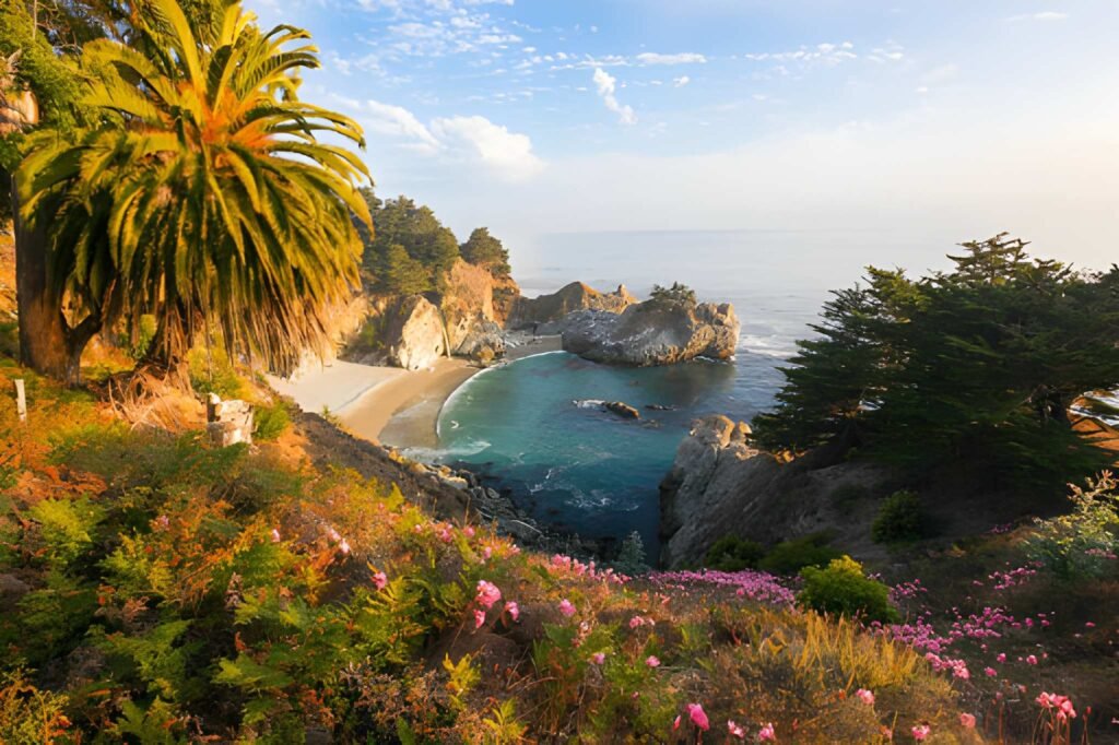
McWay Falls tumbles 80 feet onto the beach at Julia Pfeiffer Burns State Park, creating Big Sur’s most iconic image. The waterfall is one of only two in California that falls directly onto beaches (though high tide sometimes means it hits rocks instead). A short quarter-mile trail from the parking area leads to an overlook platform—you cannot access the beach below. The viewing platform gets crowded during peak hours (10 AM-4 PM in summer), so arrive early morning or late afternoon for better experiences and photos. Parking costs $10.
Hurricane Point provides expansive views from 365 feet above the Pacific, looking south toward the Big Sur coast. The pullout on the east side of Highway 1 about 14 miles south of Carmel accommodates several cars. Strong winds here (hence the name) can make standing uncomfortable but create dramatic wave-watching conditions.
Pfeiffer Beach delivers the most photographed beach in Big Sur, known for its purple sand (created by manganese garnet particles) and the dramatic rock arch with a “keyhole” opening. Finding Pfeiffer Beach challenges first-timers—the unmarked Sycamore Canyon Road turnoff sits 0.8 miles south of Pfeiffer Big Sur State Park entrance. The narrow two-mile access road includes blind curves requiring slow, careful driving. Beach parking costs $15 and fills completely on busy days. Strong undertow makes swimming dangerous. Best visited during sunset when light streams through the keyhole, though this timing coincides with peak crowds.
Point Sur Lighthouse occupies a dramatic volcanic rock connected to the mainland by a sandbar. The lighthouse, built in 1889, offers guided tours ($15 adults) on most weekends and some weekdays—check schedules online before visiting. The tour includes substantial walking and stair climbing but provides fascinating history and incredible views. Allow three hours for the complete tour.
Nepenthe restaurant sits 800 feet above the Pacific, offering better views than food, though the legendary Ambrosia Burger has its fans. The terrace provides stunning coastal panoramas while you eat or drink. Lower-altitude Cafe Kevah (same ownership, just below Nepenthe) offers similar views with lighter fare and outdoor-only seating. Both stay crowded during meal times, but visiting for late afternoon drinks or early dinner avoids the worst waits.
Big Sur’s Best Beaches Beyond Highway 1
Andrew Molera State Beach requires a one-mile walk from the parking area through meadows and across the Big Sur River (sometimes challenging during high water). The effort rewards you with Big Sur’s longest beach—a wide swath of sand that extends for over a mile with dramatic rock formations at both ends. Swimming remains dangerous due to strong currents, but beachcombing and photography opportunities abound. The beach sees lighter crowds than roadside stops. Parking costs $10.
Sand Dollar Beach, located 30 miles south of Pfeiffer Big Sur State Park, stretches for nearly a mile with easier access than Andrew Molera. A short staircase descends from the parking area to the beach. This southern Big Sur location means fewer visitors. Swimming is dangerous due to undertow. The beach works well for picnics, sunsets, and peaceful relaxation. Parking costs $10.
Jade Cove and nearby coastal areas sometimes yield jade stones, particularly after winter storms move beach stones around. The steep trail down to the cove requires careful footing. Collecting jade for personal use is legal here (unlike most California beaches), making this a unique Big Sur experience. Don’t expect to find large pieces—most jade consists of small, green-hued pebbles among other beach stones.
Garrapata State Beach provides several beach access points along Highway 1 about 6.5 miles south of Carmel. The two-mile beach includes dramatic rock formations and tide pools. Several parking areas dot Highway 1, and short trails descend to different beach sections. Parking is free. Swimming is dangerous. The beach sees moderate use but never reaches the saturation levels of more famous Big Sur beaches.
Essential Big Sur Hiking Trails by Difficulty
The Ewoldsen Trail in Julia Pfeiffer Burns State Park ranks as my favorite Big Sur hike, combining redwood forest, coastal views, and reasonable challenge in a 4.3-mile loop. The trail climbs 1,600 feet through redwood groves to a ridge with spectacular ocean views before descending through different forest zones. Allow three to four hours. The trailhead starts from the McWay Falls parking area ($10), and the trail sees moderate use but rarely feels crowded. Some steep sections require reasonable fitness, but the payoff justifies the effort.
Pfeiffer Falls and Valley View Trail offers two short hikes from the same trailhead in Pfeiffer Big Sur State Park. Pfeiffer Falls Trail runs 1.6 miles round-trip to a 60-foot waterfall flowing strongest from December through May. The trail is easy, making it perfect for families or anyone wanting a short nature walk. Valley View Trail climbs more strenuously for 2 miles round-trip to a ridgetop overlook of Big Sur Valley and the ocean beyond. Both trails can be combined in a two-hour outing. Park entry costs $10.
McWay Falls Overlook Trail at Julia Pfeiffer Burns State Park provides the easiest Big Sur “hike”—really just a quarter-mile walk from the parking area to viewing platforms overlooking the famous 80-foot waterfall. The trail is paved and wheelchair-accessible. Anyone can complete this in 15 minutes, though most linger longer to photograph the falls and coastline.
Partington Cove Trail leads 0.4 miles downhill through a tunnel hand-carved in 1880s to a small cove where lumber schooners once loaded redwood. The short trail packs historical interest and coastal beauty into minimal distance and effort. Swimming in the cove is possible during calm summer conditions, though water stays cold. The unmarked trailhead sits on Highway 1 about 2 miles north of Julia Pfeiffer Burns State Park—look for turnout parking on the west side and trail starting behind metal gate. Free access.
Andrew Molera Loop Trail combines multiple trails in Andrew Molera State Park for a 5.5-mile loop providing beach access, meadow walking, and ridge views. The trail crosses the Big Sur River (easy in summer, potentially challenging in spring), wanders through grasslands where elk graze, climbs to Creamery Meadow with panoramic views, and descends to the beach before returning. Allow three to four hours. Trail sees moderate use. Park entry costs $10.
Cone Peak Trail for experienced hikers seeking serious challenge climbs to Big Sur’s highest summit at 5,155 feet. The trail gains 2,300 feet over 2.5 miles of steep, exposed hiking. Views from the summit extend from Monterey Bay to San Simeon with the entire Big Sur coast visible. This trail requires excellent fitness, adequate water, and careful timing—afternoon fog can obscure the summit and make navigation difficult. The trailhead requires driving a dirt forest road (Cone Peak Road off Nacimiento-Fergusson Road) that demands high-clearance vehicles and adds 30+ minutes from Highway 1.
Where to Eat in Big Sur: Restaurants, Cafes, and Provisions
Big Sur’s dining scene consists of a handful of restaurants spread across 90 miles, none of them cheap, most of them mediocre by broader California standards. Understanding food options before arrival prevents both hunger and disappointment.
The Sur House at Ventana Big Sur holds a Michelin star, offering the region’s most refined dining experience. The restaurant serves California cuisine emphasizing local ingredients with ocean views from every table. Dinner runs $100+ per person before drinks, and reservations are essential even for hotel guests. The quality justifies the price if you want a serious meal in Big Sur, though you’re partly paying for the spectacular setting.
Sierra Mar at Post Ranch Inn also maintains a Michelin star, providing prix fixe lunches ($75) and dinners ($150+) with floor-to-ceiling windows overlooking the Pacific 1,200 feet below. The four-course prix fixe format limits flexibility but ensures excellent preparation. Reservations required weeks in advance for dinner, slightly easier for lunch. Non-hotel guests can eat here, making it a splurge option for special occasions.
Nepenthe, perched 800 feet above the ocean, delivers better views than food, though locals defend the Ambrosia Burger with surprising passion. The open-air terrace provides jaw-dropping coastal panoramas that make even average food taste better. Lunch or late afternoon drinks work well here—dinner prices feel steep for what you get. Expect to wait 30-60 minutes during peak meal times. Budget $25-40 per person.
Cafe Kevah sits just below Nepenthe with similar views, outdoor-only seating, and lighter fare at slightly lower prices. The breakfast burritos, quiches, and salads work well for casual meals. Service is cafeteria-style, keeping things moving despite crowds. Open for breakfast and lunch only. Budget $15-25 per person.
Big Sur Deli & General Store in the village area provides the most affordable meal option—sandwiches, breakfast burritos, and basic provisions. The deli makes decent sandwiches ($12-15) perfect for trail lunches. The attached general store sells limited groceries, camping supplies, and firewood at inflated prices. This is Big Sur’s closest thing to a grocery store, meaning “closest thing” in the loosest possible sense.
Big Sur Bakery combines a restaurant, bakery counter, and general store in one complex. Breakfast draws crowds for wood-fired pizzas and pastries. Dinner service offers California cuisine with seasonal menus. The bakery counter sells morning pastries and excellent bread. Reservations recommended for dinner. Budget $20-30 for breakfast, $40-60 for dinner per person.
Deetjen’s Big Sur Inn Restaurant serves breakfast and dinner in a historic, candlelit dining room that feels transported from the 1930s. Breakfast includes excellent pancakes and benedicts ($15-20). Dinner offers comfort food classics rather than cutting-edge cuisine, but the atmosphere compensates. No reservations for breakfast; dinner reservations essential on weekends.
The limited restaurant options mean Big Sur dining requires advance planning. Make dinner reservations when you book accommodations, especially for weekend visits. Bring snacks and drinks from outside Big Sur to avoid complete dependence on expensive local options. If camping or staying in accommodations with kitchens, grocery shop before arriving—the Big Sur Deli’s limited selection comes at grocery store prices you’d expect in Manhattan.

Practical Big Sur Planning: Budget, Logistics, and Insider Tips
What Big Sur Actually Costs
Big Sur empties wallets faster than almost anywhere else in California. Here’s realistic daily budget expectations:
Budget Travel ($150-200 per person per day):
- Camping ($35-50 per night split between two people)
- Groceries and simple meals from Big Sur Deli ($30-40 per day)
- Park entry fees ($10-15 per day)
- Gas (budget extra for expensive Big Sur station)
- Total works only if you camp, cook most meals, and do free activities
Mid-Range Travel ($300-400 per person per day):
- Mid-range lodging ($200-350 per night split between two)
- Mix of restaurant meals and simple options ($60-80 per day)
- Park fees and activity costs ($20-30 per day)
- Gas and incidentals ($20-30 per day)
- This reflects most visitors’ actual spending
Luxury Travel ($600-1,000+ per person per day):
- Luxury resort accommodations ($800-1,500 per night split between two)
- Dining at resort restaurants ($150-250 per day)
- Spa services and activities ($100-200 per day)
- All park fees and incidentals
- This is what Big Sur’s famous resorts actually cost
Gas deserves special mention. The Big Sur Gas Station typically charges $7-8 per gallon, about double California’s already high average. Fill up before arriving and again before leaving. Never arrive in Big Sur with less than half a tank.
Cell service is nonexistent throughout much of Big Sur. AT&T and Verizon work intermittently near populated areas (Carmel Highlands, Big Sur Village area) but provide no service for long stretches. Download offline maps before arriving. Don’t rely on GPS or navigation apps requiring internet connectivity.
Best Time to Visit for Different Priorities
For best weather and clearest views: September through October delivers warm days, minimal fog, and that golden California light everyone photographs.
For fewest crowds: January through March sees dramatically reduced visitor numbers, though weather becomes unpredictable and Highway 1 closures more likely. Weekdays any time of year provide calmer experiences than weekends.
For waterfalls and green landscapes: March through May brings maximum waterfall flows and vibrant green hills from winter rains. McWay Falls and other seasonal waterfalls reach peak volume.
For wildflowers: April and early May showcase California poppies, lupine, and dozens of other species blooming throughout Big Sur’s hillsides.
For avoiding high costs: Winter months (excluding holidays) see the lowest hotel rates and easiest availability. Some businesses close or reduce hours during this season.
Highway 1 Status and Closure Information
Before any Big Sur trip, check current Highway 1 conditions:
- Caltrans QuickMap: quickmap.dot.ca.gov
- Big Sur California: bigsurcalifornia.org/highway-1-status
- Caltrans District 5 Twitter: @CaltransD5
Major closures can last months and completely change Big Sur access. Recent closures have cut Highway 1 at various points, sometimes allowing access from north but not south, or vice versa. Winter storms trigger most closures, but Highway 1’s inherent instability means closures can happen any time.
If Highway 1 closes during your trip, alternative access routes don’t exist. The highway is the only way in or out of Big Sur. Closures mean either canceling plans or accessing only the portion still open from your direction.
What to Pack Beyond Obvious Essentials
Layers matter more in Big Sur than almost anywhere else. Temperature swings of 20-30 degrees between morning fog and afternoon sun are normal. Coastal areas run 15-20 degrees cooler than inland sections. Pack:
- Warm jacket for fog and wind (even summer)
- Sun hat and sunscreen for clear weather
- Comfortable hiking shoes with grip (trails can be steep)
- Daypack for carrying layers and water on trails
- Reusable water bottle (drinking water is scarce)
- Headlamp if camping (darkness here is complete)
- Cash (some businesses don’t accept cards, cell service unreliable for mobile payments)
- Offline maps downloaded to your phone
- Physical California road atlas as backup
- First aid kit (you’re far from medical facilities)
- Extra food and water beyond what you think you need
Photography Tips for Better Big Sur Photos
Light quality matters enormously in Big Sur. The golden hour before sunset produces the warm, glowing images you see on Instagram. Morning light works well for east-facing coastline but leaves west-facing areas in shadow. Midday sun creates harsh contrasts and washed-out skies.
Fog is simultaneously Big Sur’s photography blessing and curse. Light fog adds atmospheric drama to images. Heavy fog obscures everything. Partially burned-off fog creates layered, moody scenes. Learn to work with fog rather than fighting it—some of my best Big Sur photos happened during conditions I initially thought would ruin the day.
For McWay Falls, afternoon light illuminates the waterfall and beach best. Morning leaves the cove in shadow. Weekday mornings provide fewer crowds at the viewing platform.
Bixby Bridge photographs best from the north side pullout with morning or midday light. Sunset light hits the bridge beautifully but parking becomes extremely difficult.
Pfeiffer Beach’s keyhole rock requires sunset timing for the iconic “light through the arch” shot, achievable only during certain times of year (December-January best). Arrive 90 minutes before sunset to secure parking.
Big Sur Itinerary Suggestions
One Day Big Sur Drive-Through
Southbound Carmel to San Simeon (6-7 hours):
- Depart Carmel by 8 AM
- Stop at Bixby Bridge for photos (15 minutes)
- Continue to Point Sur Lighthouse area for views
- McWay Falls viewing platform (30 minutes)
- Lunch at Big Sur Bakery or Nepenthe (90 minutes)
- Pfeiffer Beach if time allows (60-90 minutes)
- Continue south to San Simeon or turn back to Carmel
This timeline assumes moderate traffic and brief stops. Add hours during peak summer weekends when traffic slows and parking requires waiting.
Two-Day Big Sur Weekend
Day 1:
- Morning arrival from Carmel or Monterey
- Check into accommodation
- Pfeiffer Falls hike (90 minutes)
- Lunch at Big Sur Bakery
- McWay Falls viewing platform
- Explore Pfeiffer Beach late afternoon
- Dinner at Deetjen’s or cook at campsite
Day 2:
- Early morning Ewoldsen Trail hike (3-4 hours)
- Lunch packed on trail or at Cafe Kevah
- Afternoon beach time at Andrew Molera or Sand Dollar
- Sunset from Nepenthe terrace with drinks
- Depart or stay second night
Three-Day Big Sur Immersion
Day 1: Northern Big Sur focus
- Arrive morning, check into accommodation
- Garrapata Beach exploration
- Lunch provisions from Big Sur Deli
- Andrew Molera Loop Trail afternoon (3-4 hours)
- Dinner at Big Sur Bakery
Day 2: Southern Big Sur and challenging hiking
- Early start for Ewoldsen Trail (3-4 hours)
- Lunch at Cafe Kevah with views
- Afternoon at Pfeiffer Beach
- Sunset and dinner at Nepenthe
Day 3: Recovery and departure
- Easy morning at Pfeiffer Falls
- McWay Falls platform visit
- Lunch in Carmel or Cambria depending on departure direction
- Scenic drive out with photo stops
The Real Story About Big Sur
The truth about Big Sur is that it’s simultaneously exactly as magical as photographs suggest and significantly more challenging than Instagram makes it appear. The same dramatic landscape that creates those jaw-dropping views also means limited services, expensive everything, and practical challenges that catch unprepared visitors off guard.
I’ve watched people arrive in Big Sur with completely unrealistic expectations—expecting beach resort amenities in a wilderness setting, assuming abundant restaurants and services along the entire coast, planning ambitious itineraries without accounting for slow Highway 1 driving, and becoming frustrated when reality doesn’t match their mental picture.
But I’ve also seen Big Sur exceed even optimistic expectations for visitors who arrive prepared. People who understand this is wilderness first and tourist destination second. Travelers who embrace Big Sur’s limitations as part of its character. Photographers who work with fog instead of cursing it. Hikers who start trails early to beat crowds and heat.
Big Sur rewards preparation, flexibility, and the right mindset. Book accommodations well ahead. Budget more than you think you need. Bring food from outside the region. Download offline maps. Check Highway 1 status before leaving. Build extra time into your schedule. Accept that fog might obscure views and that you might have to change plans.
Do all that, and Big Sur delivers experiences you’ll remember for life. The coastline really is that dramatic. The trails really do lead to views that make you stop and stare. The sunset light really does transform ordinary scenes into magic. The morning fog rolling through redwood forests really does feel primordial and ancient.
Big Sur isn’t easy. It’s expensive, logistically challenging, and sometimes frustrating. But it’s also one of the most spectacular stretches of coastline anywhere on earth, and once you’ve spent time here—really spent time, not just driven through—you’ll understand why people return again and again despite the challenges.
Start planning now. Book accommodations months ahead if visiting during peak season. Build flexible itineraries that account for weather and traffic. Bring patience, bring layers, bring your camera, and bring willingness to adapt.
Big Sur will reward you with memories that last far longer than the temporary discomfort of expensive gas or crowded parking lots. Some places justify their difficulties. Big Sur is one of them.
