

I’m standing at Bridge 4 in Muir Woods, surrounded by redwood giants that were alive when Columbus sailed to America. The fog rolls through the canopy like slow-motion ocean waves, and the only sounds are Redwood Creek’s gentle babble and the occasional whisper of wind through branches two hundred feet above my head. After seventeen visits to Muir Woods National Monument over the past eight years—exploring every trail combination from the easy boardwalk loops to the challenging mountain climbs—I’ve discovered that most visitors experience only a fraction of what this ancient forest offers.
The typical Muir Woods experience involves walking the crowded main trail to Cathedral Grove, snapping photos, and leaving within an hour. That’s fine, but it means missing the quiet magic of trails like Lost Trail, where I’ve hiked entire afternoons without seeing another person, or the stunning Pacific Ocean panoramas from the Canopy View Trail that most guidebooks barely mention. Whether you’re a first-time visitor trying to understand the trail system, a family looking for stroller-friendly paths, or an experienced hiker wanting to escape the crowds on routes that connect to Mount Tamalpais State Park, this comprehensive guide will show you exactly which hiking trails in Muir Woods match your goals, fitness level, and available time.
Quick Reference: Muir Woods Hiking Trails at a Glance
| Trail Name | Distance | Difficulty | Time | Elevation Gain | Crowd Level | Best For |
|---|---|---|---|---|---|---|
| Main Trail Loop | 1-1.75 miles | Easy | 45-60 min | Minimal | Very High | First-timers, families, wheelchairs |
| Fern Creek Loop | 2.5 miles | Easy-Moderate | 1.5 hours | 200 ft | Moderate | Families with older kids |
| Hillside Trail | 3 miles | Moderate | 2 hours | 400 ft | Low | Crowd avoiders |
| Lost Trail Loop | 3.5 miles | Moderate | 2-2.5 hours | 450 ft | Very Low | Solitude seekers |
| Canopy View Loop | 3.9 miles | Moderate | 2.5 hours | 820 ft | Low | View chasers |
| Bootjack Trail | 7 miles | Moderate-Hard | 3.5-4 hours | 1,100 ft | Low | Half-day adventurers |
| Dipsea to Stinson Beach | 7-10 miles | Hard | 4-5 hours | 1,400 ft | Moderate | Beach finish lovers |
| Ben Johnson to Mt. Tam | 10+ miles | Hard | 5-7 hours | 2,200 ft | Low | Serious hikers |
Best Time to Visit: Weekday mornings before 10 AM (April-October) or any winter weekday
Parking Cost: $10 standard vehicle | $13 electric vehicle | $30-45 oversized
Park Entry Fee: $15 per adult (16+) | Free for kids 15 and under
Drive Time from San Francisco: 30-75 minutes (traffic dependent)
Reservation Window: Up to 90 days in advance at GoMuirWoods.com
Understanding the Muir Woods Trail System (What Most Guides Get Wrong)
Before diving into specific trails, let me clear up the confusion that trips up almost every first-time visitor. Muir Woods National Monument is actually quite small—just 554 acres tucked into a narrow canyon. The monument contains about 6 miles of maintained trails, but several popular routes continue beyond the park boundaries into Mount Tamalpais State Park, which adds another 60+ miles of interconnected trails.
The trail system centers on Redwood Creek, which runs through the valley floor. The main paved trail follows this creek and features four numbered bridges that serve as key landmarks and decision points. Everything else branches off from this central corridor, climbing the canyon walls or heading toward neighboring parks. I learned this the hard way during my first visit when I studied those zoomed-out maps showing the entire Mount Tamalpais trail network and felt completely overwhelmed. Focus first on the monument itself, then consider the extended options.
Here’s what makes Muir Woods unique among California redwood parks: the reservation system means you know exactly when you’re visiting, but it also means spontaneity is impossible. I’ve adjusted my approach over the years—I now book parking reservations the moment they become available 90 days out, especially for weekend visits between May and October when slots disappear within hours of release.
The terrain breaks down into three distinct zones. The valley floor trails (Main Trail, Fern Creek) are flat, paved or boardwalk, and suitable for wheelchairs and strollers. The mid-elevation trails (Hillside, Lost Trail, Canopy View) climb 200-800 feet on dirt paths with roots and occasional steep sections. The high-elevation routes (Dipsea, Ben Johnson, Bootjack) ascend 1,000+ feet and connect to ridge trails with ocean views and mountain vistas.
The Main Trail Loop: Your Gateway to Muir Woods
Distance: 1-1.75 miles round-trip | Time: 45-75 minutes | Difficulty: Easy | Surface: Paved/boardwalk
This is Muir Woods’ signature experience, and for good reason. The paved main trail follows both sides of Redwood Creek, allowing you to create loops of varying length by crossing any of the four bridges. During my most recent visit in October 2024, I arrived at 9 AM on a Tuesday and had Cathedral Grove almost to myself for about twenty minutes before tour groups started arriving around 9:30.
The trail starts at the visitor center and immediately immerses you in old-growth coastal redwoods. Within the first quarter-mile, you’ll encounter the famous Pinchot Tree, a massive redwood named after Gifford Pinchot, the first chief of the U.S. Forest Service. The boardwalk section between here and Bridge 2 provides the most accessible viewing—completely flat, wide enough for wheelchairs side-by-side, and featuring interpretive signs explaining redwood ecology.
Cathedral Grove sits between Bridges 2 and 3, and it’s where most visitors stop for photos. The grove contains some of the monument’s tallest trees, reaching 250-260 feet, with several specimens estimated at 600-800 years old. The name fits—there’s something genuinely cathedral-like about standing in this circular grove with ancient columns of red-brown bark disappearing into the fog. I’ve brought out-of-town visitors here at least a dozen times, and the reaction is always the same: stunned silence followed by whispered awe.
Bohemian Grove, just past Bridge 3, marks another highlight. This grove was the site of the 1930s Bohemian Club gatherings, and the trees here grow in particularly tight formation, creating an enclosed feeling that’s quite different from the more open Cathedral Grove. A cross-section of a 1,021-year-old tree sits near Bridge 2, offering perspective on just how ancient these forests are.
Most visitors turn around at Bridge 3 or 4, making the total distance about 1.5 miles. If you cross Bridge 4 and continue on the main trail, it becomes the Bootjack Trail and heads deeper into less crowded territory. For a classic first visit, I recommend walking to Bridge 4 on one side of the creek, crossing over, and returning on the opposite side to see different angles on the same groves. This creates about a 1.75-mile loop that shows you the monument’s greatest hits in under two hours.
What to expect: Heavy crowds between 10 AM and 3 PM on weekends and summer weekdays. The trail gets congested, and finding spots for photos without other people in the frame becomes challenging. Winter weekday mornings (January-March) offer the most solitude, though prepare for muddy conditions and expect the fog to be particularly thick, which actually enhances the mystical atmosphere.
Accessibility notes: This is California’s most accessible old-growth redwood experience. The entire paved section accommodates wheelchairs, electric scooters, and strollers easily. Restrooms near the visitor center include accessible facilities with changing tables. The only limitation is that accessible parking spaces (10 spots total) book up even faster than standard spots—reserve the full 90 days in advance if you need accessible parking.
Fern Creek and Hillside Loop: Escaping the Crowds
Distance: 2.5-3 miles | Time: 1.5-2 hours | Difficulty: Easy to Moderate | Elevation: 200 feet
This combination ranks as my go-to recommendation for visitors who want more than the main trail but aren’t ready for serious elevation gain. The loop takes you past all the main trail highlights, then adds Fern Creek’s lush canyon atmosphere and Hillside Trail’s elevated perspective through quieter sections where you’ll encounter maybe a dozen other hikers on a busy day.
Start on the main trail and follow it to Bridge 4, enjoying Cathedral Grove and Bohemian Grove along the way. At Bridge 4, look for the Hillside Trail sign on your right before you cross the bridge. This is where you leave the crowds behind. The trail immediately begins climbing via a moderately steep dirt path lined with sword ferns, wood ferns, and occasional patches of redwood sorrel with their distinctive clover-like leaves.
The Hillside Trail hugs the canyon wall about 100-200 feet above the valley floor, offering angles on the redwood canopy you simply can’t get from the main trail. I’ve spent entire afternoons on this section during summer, resting on fallen logs and watching light filter through the canopy in those rare moments when fog lifts enough for direct sunlight to penetrate. The trail is narrow but well-maintained, with occasional steep sections that require watching your footing on exposed roots.
After about 1.2 miles on Hillside Trail, you’ll intersect with Fern Creek Trail. Turn right to descend back toward the valley floor through some of the monument’s densest fern groves. This section earned its name—massive five-leaf ferns, leather ferns, and lady ferns create walls of green on both sides of the trail. During spring (March-May), you’ll hear Fern Creek’s increased flow from winter rains, though by late summer the creek often runs quite low or dry in spots.
Fern Creek Trail returns you to the main trail near Bridge 3. From here, you can either walk back to the visitor center or cross the bridge and continue exploring. Total loop time runs 1.5-2 hours depending on how often you stop for photos and rest breaks. The combination of paved main trail, moderate climbing on Hillside, and the descent through Fern Creek gives you excellent redwood variety without requiring serious fitness levels.
Crowd strategy: The main trail portion will be busy, but once you turn onto Hillside Trail at Bridge 4, crowds drop dramatically. I’ve hiked this loop on Saturday mornings and encountered fewer than twenty people on the entire Hillside and Fern Creek section. Most visitors simply don’t venture beyond the bridges, which works beautifully in your favor.
What to pack: Even though this is a moderate hike, the elevation changes mean you’ll work up some warmth. I always wear layers—start with a base layer and light fleece, and expect to shed the fleece once you’re climbing Hillside Trail. Trekking poles help on the steeper sections, especially if the trail is damp from fog drip or recent rain. Water is essential; bring at least 32 ounces per person.
Lost Trail Loop: For True Solitude
Distance: 3.5 miles | Time: 2-2.5 hours | Difficulty: Moderate | Elevation: 450 feet
Lost Trail earned its name after being buried by a 1930s landslide and remaining hidden for three decades until trail crews relocated and rebuilt it in the 1960s. Today, it’s Muir Woods’ secret weapon for finding solitude. During a July 2023 Saturday afternoon visit—peak tourist season, peak day, peak time—I completed the entire Lost Trail section and encountered exactly three other hikers. That’s the kind of experience you simply can’t find on the main trails.
Access Lost Trail from the main trail near Bridge 2 or by following the Canopy View Trail from Bridge 1. I prefer the latter approach because it adds variety and spreads out your elevation gain. From the visitor center, take the main trail to Bridge 1, cross over, and look for the Canopy View Trail sign on your left. This trail climbs moderately for about 0.7 miles through mixed Douglas fir and redwood forest.
Where Canopy View meets Ocean View Trail (also called Panoramic Trail), turn left onto Ocean View Trail. After approximately 0.6 miles of gentle climbing with occasional steep pitches, you’ll see the Lost Trail junction on your left. This is where the magic starts. Lost Trail descends through deep, quiet forest where massive Douglas firs mix with redwoods, creating a different canopy structure than the pure redwood groves below.
The descent is gradual and peaceful, following contour lines along the canyon wall. You’ll cross several small seasonal streams (usually dry by August) and wind through fern-filled ravines. The lack of other hikers means you’ll actually hear the forest—bird calls, wind in branches, the distant sound of Redwood Creek far below. I’ve seen deer on Lost Trail three times, each time in the early morning when animals are most active before day hikers arrive.
Lost Trail eventually intersects Fern Creek Trail. Turn right to return to the main trail, or turn left to extend your hike further into the backcountry. The standard Lost Trail Loop brings you back to the main trail near Bridge 3, from where you can walk the remaining distance back to the visitor center. Total distance runs about 3.5 miles with 450 feet of elevation gain spread throughout the loop, making it more manageable than the numbers might suggest.
Why this trail works for solitude: Most visitors stick to the paved main trail or, at most, venture onto Hillside Trail. Lost Trail requires slightly more commitment and comfort with dirt trails, which immediately filters out 90% of monument visitors. The trail also lacks the “must-see” landmarks like Cathedral Grove, so guidebooks mention it briefly or skip it entirely.
Best time for Lost Trail: Weekday mornings year-round, but especially magical during winter when fog creates an ethereal atmosphere. I hiked Lost Trail during a January 2024 visit, and the combination of thick fog, minimal visitors, and damp forest smells created one of my most memorable Muir Woods experiences. Summer afternoons work well too—by 2 PM, most day-trippers have left, and you’ll have the trail almost to yourself.
Canopy View Trail: Hidden Ocean Panoramas
Distance: 3.9 miles | Time: 2.5-3 hours | Difficulty: Moderate | Elevation: 820 feet
Here’s what surprises people about Muir Woods: while the monument is famous for redwoods, some of the most spectacular views come from trails that climb above the redwood canopy to ridges offering Pacific Ocean panoramas and San Francisco Bay vistas. Canopy View Trail delivers exactly this experience, climbing from the valley floor to the Ocean View Trail junction, where on clear days you’ll see the ocean shimmering in the distance.
The trail begins near Bridge 1, immediately climbing through a transitional forest zone where redwoods give way to Douglas fir, bay laurel, and occasional tan oak. This first section is the steepest part of the hike—about 400 feet of elevation gain in the first half-mile. It’s a workout, but the trail uses well-designed switchbacks that make the climb manageable if you pace yourself and take breaks.
After about 0.7 miles, you’ll intersect Ocean View Trail (sometimes called Panoramic Trail on older maps). Turn right here, and the trail begins following the ridge toward Panoramic Highway. This section provides the payoff for your climbing effort. When fog clears—typically in late morning on sunny days between May and September—you’ll catch glimpses of the Pacific Ocean to the west and occasionally see San Francisco’s skyline and the Golden Gate Bridge to the south.
The vegetation shifts completely up here. You’re now in chaparral and mixed hardwood forest, with manzanita, coyote brush, and scrub oak replacing the moisture-loving plants of the valley floor. During my September 2024 hike, temperatures at the ridge were at least 15 degrees warmer than in the redwood groves below. Bring sun protection and extra water—the exposed ridge sections offer little shade.
For the standard Canopy View Loop, follow Ocean View Trail for about 1.3 miles, then take Lost Trail back down to reconnect with the valley floor via Fern Creek Trail. This creates a 3.9-mile loop showcasing three distinct ecosystems in a single hike. Alternative route: instead of descending Lost Trail, continue on Ocean View Trail to where it meets Panoramic Highway, then take the Redwood Trail and Sun Trail loop back down (this adds about 2 miles and another hour).
View quality varies significantly: I’ve hiked Canopy View twelve times, and only on four occasions did I get genuinely clear ocean views. Muir Woods sits in a fog belt, and even when San Francisco enjoys sunshine, the monument often remains socked in. Summer afternoons (June-August) offer your best shot at clearing fog. Winter visits rarely provide views but offer the trade-off of emptier trails and dramatic fog effects.
Wildlife watching: The ridge sections see more wildlife than valley floor trails. I’ve spotted hawks, turkey vultures, deer, and once a bobcat crossing the trail at dawn. The openness and quieter traffic make this excellent territory for bird watching—bring binoculars if you’re interested in spotting local species like Steller’s jays, varied thrushes, and Pacific wrens.
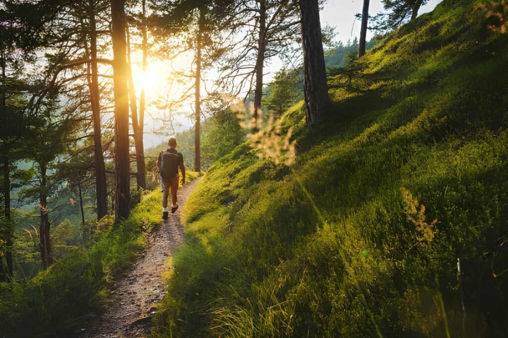
Bootjack Trail: The Half-Day Adventure
Distance: 7 miles round-trip | Time: 3.5-4 hours | Difficulty: Moderate to Hard | Elevation: 1,100 feet
Bootjack Trail represents Muir Woods’ premier half-day hiking experience, combining everything that makes this area special: old-growth redwoods, stream crossings, historical sites, and connection to the broader Mount Tamalpais trail network. This is the hike I recommend when friends visit who are reasonably fit and want to see beyond the typical tourist experience.
The trail begins where the main trail ends at Bridge 4, though officially it’s just a continuation of the same path following Redwood Creek upstream. For the first mile beyond Bridge 4, you’re still in classic redwood habitat, but crowds have dropped to almost nothing. I’ve started this hike at 10 AM on summer Saturdays and encountered maybe five other hikers in the first hour, compared to hundreds on the main trail section.
After about 1.5 miles, the forest opens at Van Wyck Meadow, a historic gathering site used by the Miwok people and later by early 20th-century hikers. The meadow provides a natural rest stop and marks the transition point where the trail begins climbing more steeply. In spring (March-May), wildflowers fill the meadow—lupine, California poppies, and Indian paintbrush create colorful displays that contrast beautifully with the deep green of surrounding forest.
Past the meadow, Bootjack Trail enters terrain built during World War I by the Tamalpais Conservation Club, one of those fascinating historical details that adds depth to the hiking experience. The trail crosses multiple side canyons while maintaining relatively level elevation around 400 feet, using carefully constructed switchbacks and rock work that has held up remarkably well for over 100 years.
At the TCC Trail junction (about 2.5 miles from Bridge 4), you face a decision. Taking the left fork continues on Bootjack Trail toward Bootjack Campground and eventually Pantoll Ranger Station in Mount Tamalpais State Park. The right fork follows Stapleveldt Trail back toward Muir Woods. For a standard Bootjack loop, take Stapleveldt Trail, which descends gradually through more redwood groves before reconnecting with the main trail system near Bridge 4.
The full loop runs about 7 miles and typically takes 3.5-4 hours including rest stops, snack breaks, and time to enjoy Van Wyck Meadow. Elevation gain totals around 1,100 feet, but it’s spread throughout the hike rather than concentrated in brutal climbing sections. This makes Bootjack accessible to moderately fit hikers who might struggle with steeper, shorter climbs.
What I pack for Bootjack: This half-day adventure requires more substantial preparation than shorter loops. I always bring 64-96 ounces of water per person, substantial snacks or lunch, a lightweight rain jacket even on sunny days (weather can change quickly in this microclimate), and a basic first aid kit. The trail has no facilities beyond Van Wyck Meadow, and cell service is nonexistent throughout.
Best season: Spring (April-May) offers the perfect combination of flowing streams, green landscapes, and wildflower displays at Van Wyck Meadow. Summer works well too, though expect warmer temperatures in exposed sections. I avoid Bootjack during heavy winter rain (December-February) as creek crossings can become challenging and trail conditions deteriorate with mud.
Dipsea Trail to Stinson Beach: The Epic Hike
Distance: 7-10 miles one-way | Time: 4-5 hours | Difficulty: Hard | Elevation: 1,400 feet gain, 1,600 feet loss
This trail combination represents Muir Woods hiking at its most ambitious and rewarding. You’ll climb from the redwood canyon to Mount Tamalpais ridges, traverse varied ecosystems from fog-soaked forest to sun-baked chaparral, and finish with your toes in the sand at Stinson Beach. It’s the hike I save for visiting friends who are serious hikers and want a full-day adventure that showcases the incredible diversity of Marin County’s landscapes.
Here’s the logistics reality: this is a one-way hike, which means you need to solve the car shuttle problem or arrange pickup at Stinson Beach. Most people park at Stinson Beach (free parking, no reservation needed), take Marin Transit bus or arrange rideshare to Muir Woods, then hike back to their car. Alternative: some hikers leave a bicycle locked at Muir Woods, hike to Stinson Beach, then bike back (about 5 miles via Shoreline Highway, taking 30-45 minutes for reasonably fit cyclists).
The route follows either the Dipsea Trail or Ben Johnson Trail out of Muir Woods—both connect to ridges heading toward Stinson Beach, with Dipsea being slightly shorter but steeper. I prefer starting on Ben Johnson Trail from Bridge 3, which climbs through gorgeous redwood groves for about 1.5 miles before emerging onto open ridges with spectacular views.
The middle section traverses Mount Tamalpais State Park along ridge trails with constant elevation changes—you’re either climbing or descending, rarely on level ground. This is where the hike earns its “hard” rating. The cumulative elevation gain and loss wears on your legs, and the exposed sections offer no shade during sunny conditions. I completed this hike on a July afternoon with temperatures hitting 85 degrees on the ridges, and the lack of shade made those final miles genuinely challenging.
The last two miles descend steeply into Stinson Beach through a series of switchbacks. Your quads will burn, and if you haven’t maintained good hiking posture, your knees will protest. Trekking poles become invaluable for this descent. Then, suddenly, you emerge from forest onto Stinson Beach’s wide sandy expanse with the Pacific Ocean stretching to the horizon. Few hiking experiences in the Bay Area offer such a dramatic transition from ancient forest to open beach.
Planning considerations: Start early—I recommend beginning the hike no later than 9 AM to ensure you complete the hike with daylight margin. The full route takes most hikers 4-5 hours, but add time for breaks, photos, and potential navigation confusion (trail junctions can be tricky in several spots). Bring significantly more water than you think you need—3-4 liters per person is not excessive on warm days. The only water source is at Muir Woods visitor center, so fill up before starting.
What makes this hike special: Beyond the physical challenge and stunning scenery, the Dipsea Trail carries serious local significance. It’s the route of the oldest trail race in America, the Dipsea Race, which has run annually (except during World Wars) since 1905. You’ll follow the same path generations of runners have taken, including the famous “steep ravine” section near Stinson Beach where hundreds of wooden steps descend through dense forest.
Realistic assessment: This hike isn’t for everyone, and that’s perfectly fine. If you’re not comfortable with steep elevation changes, questionable trail navigation, and 4-5 hours of continuous hiking, choose one of the shorter loops instead. I’ve seen too many exhausted hikers struggling through the final miles, turning what should be an adventure into an ordeal. Be honest about your fitness level and experience before committing to this route.
Trail Conditions by Season: What to Expect Year-Round
Muir Woods looks and feels dramatically different across seasons, and understanding these changes helps you choose the best time for your visit and pack appropriately.
Spring (March-May) brings the monument to its greenest, most vibrant state. Redwood Creek runs high from winter rains, creating genuine waterfall sounds rather than the gentle trickle of drier months. Wildflowers bloom in meadows and along trail edges—look for trillium, fairy lanterns, and wild iris adding splashes of white and purple to the forest floor. Temperatures range from 50-65°F in the shade, perfect for comfortable hiking without overheating. This is my favorite season for Muir Woods, though weekend crowds begin building by late April as weather improves.
Summer (June-August) delivers the most reliable weather but also maximum crowds. Mornings often feature heavy fog that typically burns off by midday, though some days remain socked in from dawn to dusk. Valley floor temperatures stay cool (55-70°F) thanks to fog and shade, while ridge trails can hit 80-90°F in direct sun. Creek flows drop significantly by August, and some small tributaries dry up completely. The trade-off for crowds is extended daylight—sunset doesn’t occur until after 8 PM in June, giving you flexibility for afternoon or evening hikes after day-trippers leave.
Fall (September-November) ranks as my second favorite season. September continues summer’s warm weather without peak crowds, as kids return to school and family tourism drops. October brings the first significant rains, freshening up dusty trails and increasing creek flow. Foliage remains evergreen (redwoods don’t change color), but understory plants like big-leaf maple turn golden-yellow, and autumn light filtering through fog creates magical photography conditions. Temperatures range 50-70°F, requiring layers for comfort.
Winter (December-February) transforms Muir Woods into its most atmospheric, least crowded state. Heavy rains create muddy trail conditions, especially on dirt trails like Hillside and Lost Trail. Redwood Creek runs high and fast, and you’ll hear its roar throughout the valley. Fog becomes an almost constant companion, sometimes reducing visibility to 50 feet and creating an otherworldly experience. Temperatures drop to 45-60°F, and wind chill on ridge trails can make it feel even colder. This season rewards hardy hikers with solitude—I’ve spent entire winter Wednesday mornings in Muir Woods and encountered fewer than twenty people on the main trails.
What to wear year-round: Layers are essential regardless of season. Start with a moisture-wicking base layer (synthetic or merino wool, never cotton), add a fleece or light insulated jacket, and bring a waterproof rain shell even on sunny days. Fog drip from the canopy can soak you as thoroughly as rain. Good hiking shoes or trail runners with aggressive tread handle wet, rooty trails better than casual sneakers. I’ve seen countless visitors struggling in worn-out running shoes with smooth soles, slipping on every root and rock.
Parking & Reservation Strategy: The Complete Breakdown
This is where most first-time visitors get frustrated, so let me break down exactly how the reservation system works and share strategies I’ve developed for securing spots during high-demand periods.
The Basic System: All vehicles entering Muir Woods require advance reservations made at GoMuirWoods.com or by calling 1-800-410-2419. Reservations open 90 days in advance on a rolling basis—meaning April 15 reservations become available at midnight on January 15. Standard vehicle parking costs $10, electric vehicle spots cost $13 (includes charging), and oversized vehicles (17-35 feet) cost $30-45 depending on length.
The Reality Check: Weekend reservations between May and October typically sell out within 2-4 hours of becoming available. I’ve watched summer Saturday slots disappear in under 60 minutes. Weekday reservations last longer, sometimes remaining available for several weeks, though prime morning slots (9-11 AM) still book up within days.
My Reservation Strategy: Set a calendar reminder for exactly 90 days before your desired visit date. Log into GoMuirWoods.com right at midnight Pacific Time (when new reservations become available). Have your credit card information saved in your account to speed up checkout. If your preferred date sells out, immediately check nearby dates—sometimes shifting your visit by a day makes all the difference. For absolute must-visit dates like a birthday celebration or out-of-town visitor with limited flexibility, consider booking both a parking reservation and a backup shuttle reservation.
The Entrance Fee Confusion: The $10 parking reservation is separate from the $15 per adult entrance fee. You can purchase the entrance fee when booking your parking reservation or pay upon arrival. I recommend pre-purchasing to save time at the entrance gate. The entrance fee is waived if you have an America the Beautiful Annual Pass ($80, valid at all National Parks and National Monuments—it pays for itself in 5-6 visits).
Shuttle Alternative: Muir Woods operates a shuttle system from Larkspur Landing Ferry Terminal (weekends and holidays) and Sausalito Ferry Terminal (select summer weekdays). Shuttle reservations cost $4 per adult round-trip, and kids 15 and under ride free. The downside: shuttle schedules limit your flexibility, typically giving you 2-3 hours at the monument. But if parking reservations are sold out or you prefer not driving the narrow, winding Muir Woods Road, the shuttle works well.
The “Backdoor” Approach: Several trails outside Muir Woods Monument boundaries connect to the monument’s trail system. You can park for free at Pantoll Ranger Station or Mountain Home Inn parking area (both in Mount Tamalpais State Park, no reservations required) and hike into Muir Woods via Ben Johnson Trail or Bootjack Trail. This adds 3-4 miles each way but completely bypasses the reservation system. I’ve used this approach three times when I couldn’t secure parking reservations, and while it requires more effort, the extended hiking and smaller crowds make it worthwhile.
Last-Minute Options: Check GoMuirWoods.com 3-5 days before your visit. Cancellations open up spots (reservations cancelled with 72+ hours notice get full refunds, so people do cancel regularly). Set multiple calendar alerts to check availability. I’ve successfully grabbed cancelled reservations 2-3 days before visits on several occasions.
Tour Company Alternative: If all else fails, guided tours to Muir Woods guarantee entry without the reservation hassle. Tours from San Francisco typically cost $75-110 per person and include transportation, guaranteed entry, and often stops at Sausalito or other Marin County attractions. The trade-off is limited time at the monument (usually 60-90 minutes) and less flexibility to explore trails beyond the main boardwalk.
Budget Breakdown: What Your Muir Woods Hike Actually Costs
Let me give you realistic cost estimates for different hiking scenarios, because most guides ignore this critical planning information.
Solo Budget Hiker (Main Trail Visit):
- Parking reservation: $10
- Entrance fee: $15
- Gas from San Francisco: $8-10 round-trip
- Total: $33-35 for 2-3 hour visit
Couple Budget Visit (Fern Creek Loop):
- Parking reservation: $10
- Entrance fees (2 adults): $30
- Gas: $8-10
- Snacks/water: $5-8
- Total: $53-58 for 3-4 hour visit
Family Visit with Kids (Main Trail):
- Parking reservation: $10
- Entrance fees (2 adults, 2 kids under 16): $30
- Gas: $8-10
- Snacks/lunch: $20-30
- Gift shop purchases: $15-25 (this always happens with kids)
- Total: $83-105 for half-day visit
Serious Hiker (Bootjack Trail Loop):
- Parking reservation: $10
- Entrance fee: $15
- Gas: $8-10
- Trail lunch/snacks: $12-15
- Coffee/food before hike: $8-12
- Total: $53-62 for full day visit
Epic Adventure (Dipsea to Stinson Beach):
- Parking at Stinson Beach: Free
- Rideshare to Muir Woods: $35-45
- Entrance fee: $15
- Trail snacks/water: $10-15
- Celebratory meal at Stinson Beach: $25-40
- Total: $85-115 for full day adventure
Money-Saving Tips: Purchase an America the Beautiful Annual Pass ($80) if you’re visiting multiple national parks or monuments within a year—it covers all entrance fees for everyone in your vehicle at federal sites. Bring your own water and snacks rather than purchasing at the monument (limited options, premium prices). Visit during winter weekdays when parking reservations are easier to secure and you won’t lose money to sold-out dates forcing you to reschedule.
Frequently Asked Questions (Everything You’re Wondering)
Can I visit Muir Woods without a reservation?
No, you cannot drive to Muir Woods without a parking reservation. Parking ambassadors check every vehicle entering Muir Woods Road. However, you can hike into the monument from Mount Tamalpais State Park (parking at Pantoll or Mountain Home Inn requires no reservation) or take the Muir Woods shuttle, which operates on weekends and holidays. The shuttle also requires advance reservations but typically has more availability than parking spots.
What are the best hiking trails in Muir Woods for beginners?
The Main Trail Loop (1-1.75 miles, paved) is perfect for beginners and provides wheelchair access to Cathedral Grove and Bohemian Grove. The Fern Creek Loop (2.5 miles, mostly easy) offers a step up with minimal elevation gain and beautiful fern-lined paths. Both trails showcase old-growth redwoods without requiring significant fitness levels or technical hiking skills.
How long should I plan to spend at Muir Woods?
Plan at least 2-3 hours for the Main Trail experience, 3-4 hours for moderate loops like Fern Creek or Hillside Trail, and 4-6 hours for extended hikes like Bootjack Trail. Your parking reservation is valid for your designated entry time, but there’s no limit on how long you can stay once inside the monument.
What’s the best time to visit Muir Woods to avoid crowds?
Weekday mornings before 10 AM offer the lightest crowds, especially November through March. If you must visit on weekends, arrive right when the monument opens (8 AM) or after 3 PM when most day-trippers have left. Winter weekdays (January-February) provide the most solitude but expect muddy trails and persistent fog.
Are dogs allowed on Muir Woods trails?
No, pets are not allowed on any trails within Muir Woods National Monument, with the exception of service animals. This policy protects local wildlife and helps maintain trail conditions. If you’re traveling with dogs, consider hiking in nearby Mount Tamalpais State Park instead, where leashed dogs are permitted on most trails.
Is Muir Woods stroller-friendly?
The Main Trail’s paved boardwalk section (from visitor center to about Bridge 3) accommodates strollers easily, covering approximately 1.5 miles round-trip. Beyond Bridge 3 and on any unpaved trails, strollers become impractical due to roots, narrow paths, and elevation changes. Many parents successfully use baby carriers for extended hikes.
Can I bring food and have a picnic at Muir Woods?
Yes, you can bring food, but designated picnic areas are limited. There’s a small picnic area near the visitor center with a few tables, but it’s often crowded. Most hikers pack trail snacks or lunch and eat at scenic spots along trails. No campfires or open flames are allowed. Pack out all trash—there are minimal waste receptacles on trails.
What should I wear hiking in Muir Woods?
Dress in layers regardless of season. The redwood canyon stays 10-15 degrees cooler than surrounding areas, and fog drip from trees can soak clothing. I recommend: moisture-wicking base layer, fleece or light jacket, waterproof shell, hiking shoes or trail runners with good tread, and a warm hat. Avoid cotton, which stays wet and cold. Even summer visits require long pants and closed-toe shoes for comfort on dirt trails.
Is there cell phone service in Muir Woods?
Cell service is extremely limited throughout Muir Woods. You might get weak signal near the visitor center, but trails have essentially zero coverage. Download offline maps before arriving, and don’t rely on your phone for navigation or communication. This is actually refreshing—it forces you to be present rather than constantly checking devices.
What wildlife might I see on Muir Woods trails?
Common sightings include banana slugs (bright yellow, impossible to miss), black-tailed deer, Steller’s jays, varied thrushes, and Pacific wrens. Less common but possible: bobcats, coyotes, and black bears (rare but present in the area). The monument doesn’t have dangerous wildlife, but practice standard precautions like keeping distance from deer and storing food properly.
Key Takeaways: Making the Most of Your Muir Woods Hiking Adventure
After eight years and seventeen visits exploring every hiking trail in Muir Woods, I’ve learned that this ancient redwood forest rewards those who venture beyond the obvious. The Main Trail provides a stunning introduction—Cathedral Grove and Bohemian Grove genuinely deserve their fame, and the paved accessibility means everyone can experience these 800-year-old giants. But the magic intensifies on trails like Lost Trail, where solitude replaces crowds, and Canopy View, where ocean panoramas complement towering redwoods.
The reservation system frustrates many visitors, but it also protects the very qualities that make Muir Woods special. By limiting vehicle access, the National Park Service prevents the parking chaos and ecological damage that plague unrestricted natural areas. My advice: book parking reservations the moment they become available 90 days in advance for weekend visits, or choose weekday mornings when reservations remain available longer and crowds stay minimal. The backdoor approach via Mount Tamalpais State Park trails offers reservation-free access for those willing to hike extra miles.
Budget your visit realistically. A basic Main Trail experience costs $33-35 for solo hikers (parking plus entrance fee), while families should expect $85-105 for a half-day visit including gas, snacks, and inevitable gift shop purchases. The entrance fee feels steep for what amounts to a 2-3 hour visit, but an America the Beautiful Annual Pass ($80) covers unlimited entries to all federal parks and monuments, paying for itself in just 5-6 visits across any national park or monument.
Seasonal timing matters more than most guides acknowledge. Spring (April-May) delivers the best combination of green landscapes, flowing creeks, and wildflower displays, though crowds build by late April. Winter weekdays provide maximum solitude and atmospheric fog but require tolerance for muddy conditions and limited visibility. Summer guarantees the best weather but means sharing trails with hundreds of other visitors—arrive early (before 9 AM) or late (after 3 PM) to minimize crowds during peak season.
For your first visit, walk the Main Trail to Bridge 4 and back (1.75 miles, 60-90 minutes) to experience the monument’s greatest hits. For your second visit, add the Hillside and Fern Creek loop (2.5 miles, 1.5-2 hours) to see elevated canyon perspectives and lush fern groves away from crowds. For your third visit, commit to either Lost Trail for peaceful forest immersion or Canopy View for ocean panoramas—both deliver experiences you simply cannot find on the standard tourist routes.
The hiking trails in Muir Woods offer something rare in modern life: genuine connection to ancient forest ecosystems that existed centuries before European contact with California. These coastal redwoods survived fires, floods, and near-complete logging of surrounding areas to create the living museum you’ll walk through today. Respect the reservation system, pack appropriate layers and water, and most importantly, allow yourself to slow down and truly experience these cathedral groves rather than rushing through for quick photos. The redwoods have been here for 600-1,000 years. They’ll wait patiently while you take the time to appreciate them properly.
